Last Updated on January 15, 2022 7:01 am
FOR CONTINUED UPDATES ON THE WEEKEND STORM VISIT THIS LINK
Two winter events to have impacts in the High Country to end the work week and to round out the weekend.
Here's the latest as of 4:00 pm Friday, January 14, 2022:
Winter Storm Warning issued for Avery County. More details at this link.
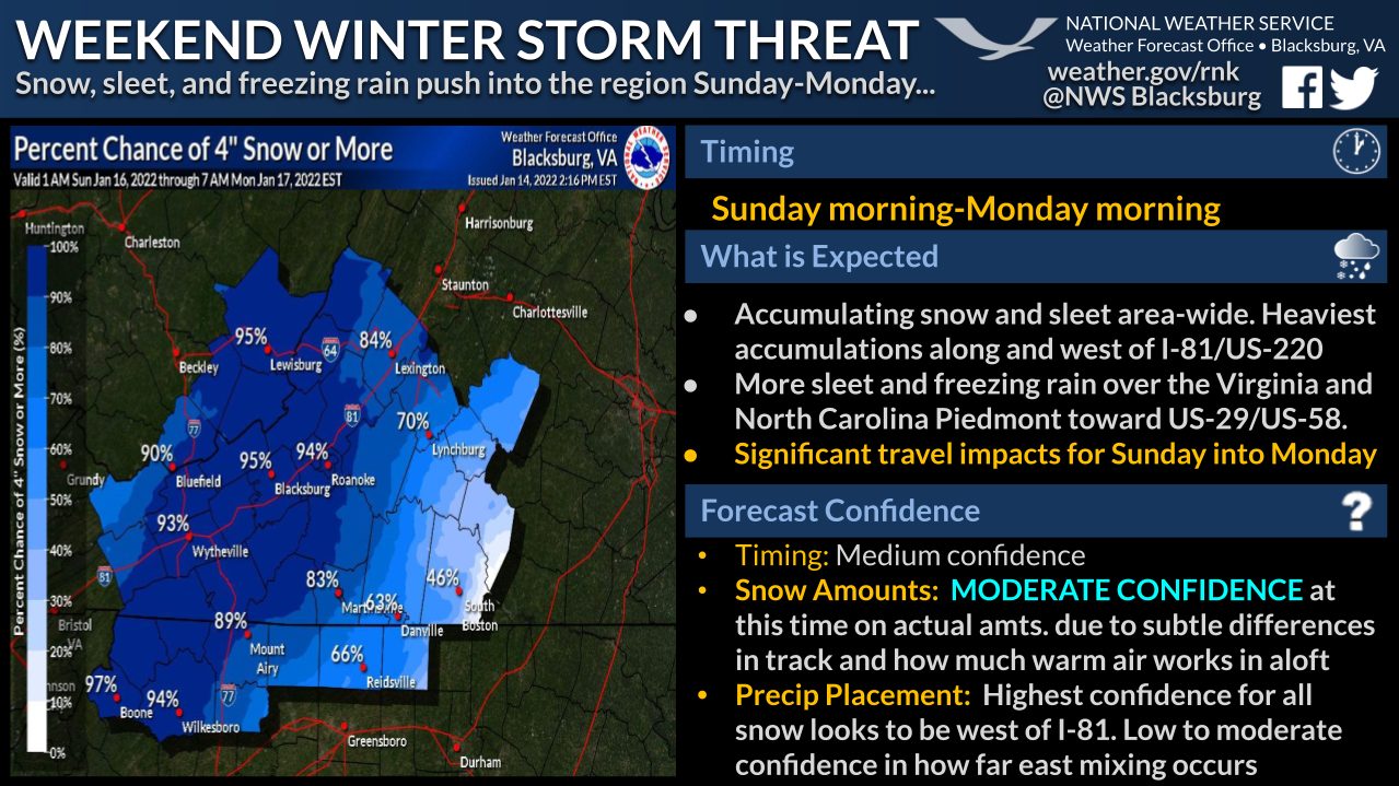
Graphic from NWS Blacksburg
Here's the latest as of 9:07 am Friday, January 14, 2022:
Winter Storm Watch issued for Watauga, Ashe & Wilkes. More details at this link.
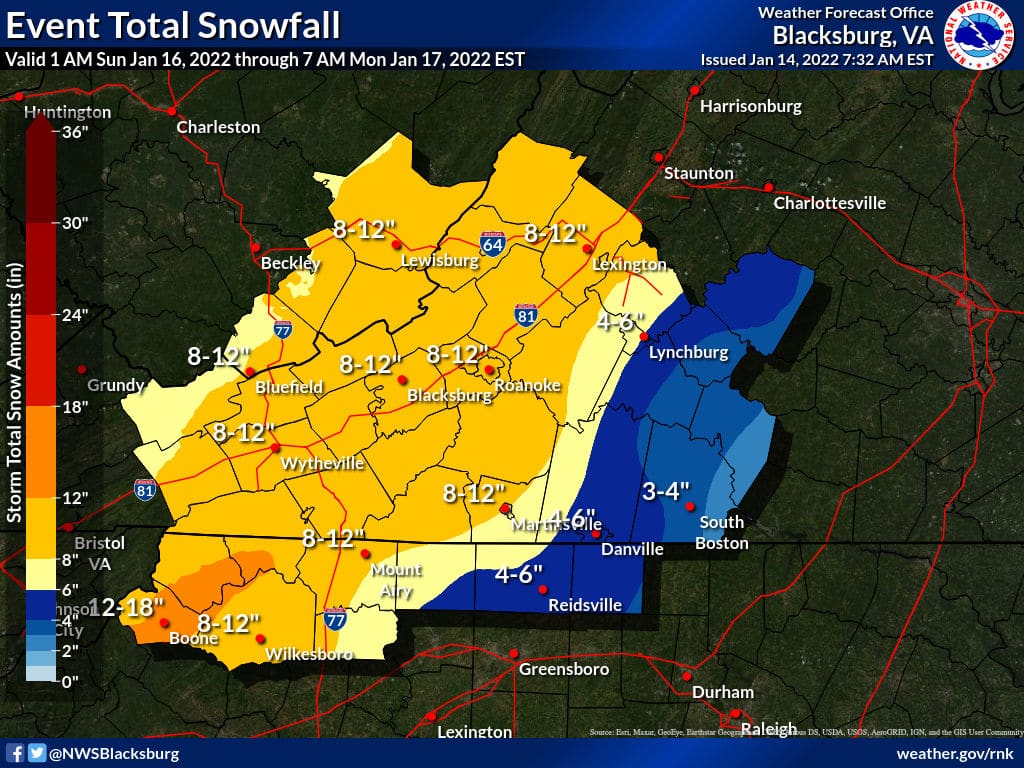
Below is an updated graphic from NWS Blacksburg regarding the expected snowfall from 1 am Sunday through 7 am Monday.
Here's the latest as of 4:21 pm Thursday, January 13, 2022:
Avery County Schools will be closed on Friday. More details at this link.
Here's the latest as of 3:47 pm Thursday, January 13, 2022:
The National Weather Service has issued a Winter Storm Watch that includes Avery County. For more information visit this link.
Here's the latest as of 3:18 pm Thursday, January 13, 2022:
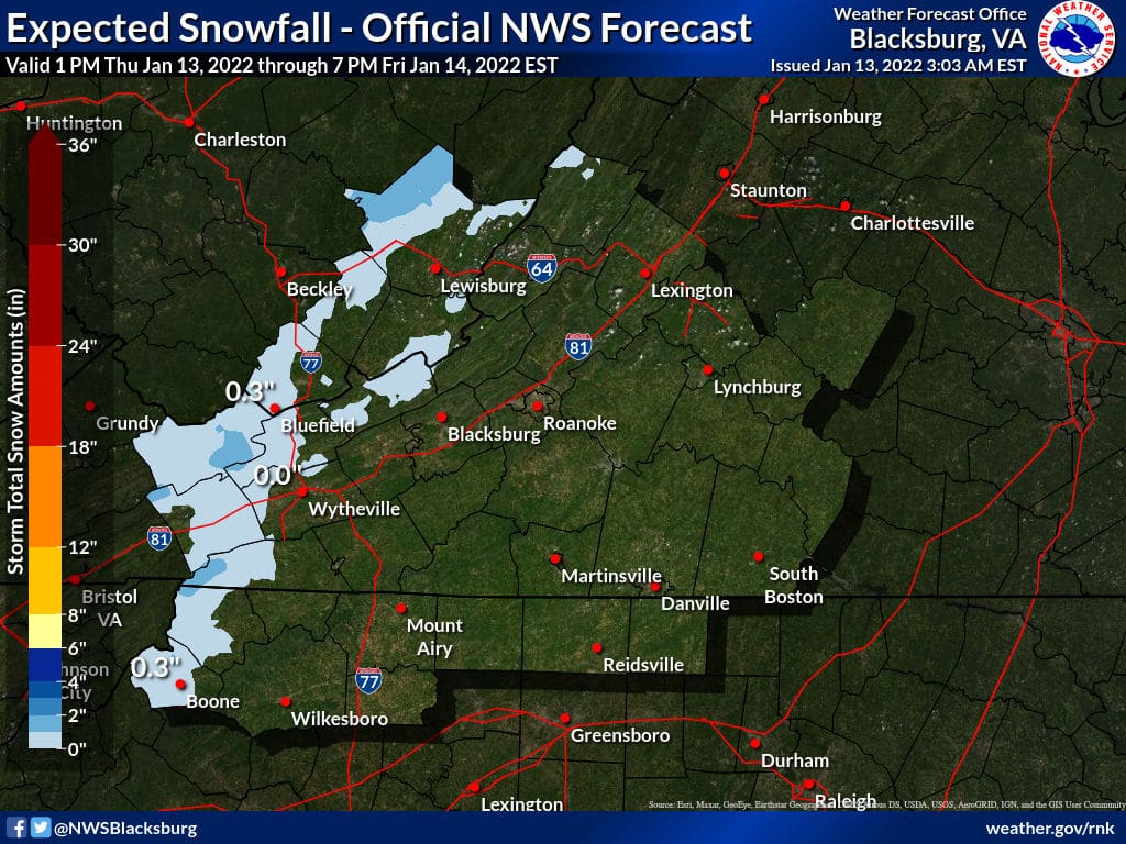
Below is a graphic from NWS-Blacksburg regarding the expected snowfall from the first weather event – tonight through Friday morning.
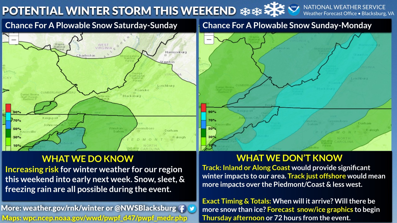
Regarding the weekend winter event NWS says in an update at 2:50 pm, “A winter storm is forecast to impact the region over the weekend, with timing mostly during the day Sunday. Accumulating snowfall is
expected, with potentially significant accumulations becoming more likely. Travel disruptions are becoming more likely. Stay tuned.”
The Town of Boone is reminding residents of the downtown snow removal procedures. You can view those at this link.
Here's the latest as of 9:58 am Thursday, January 13, 2022:
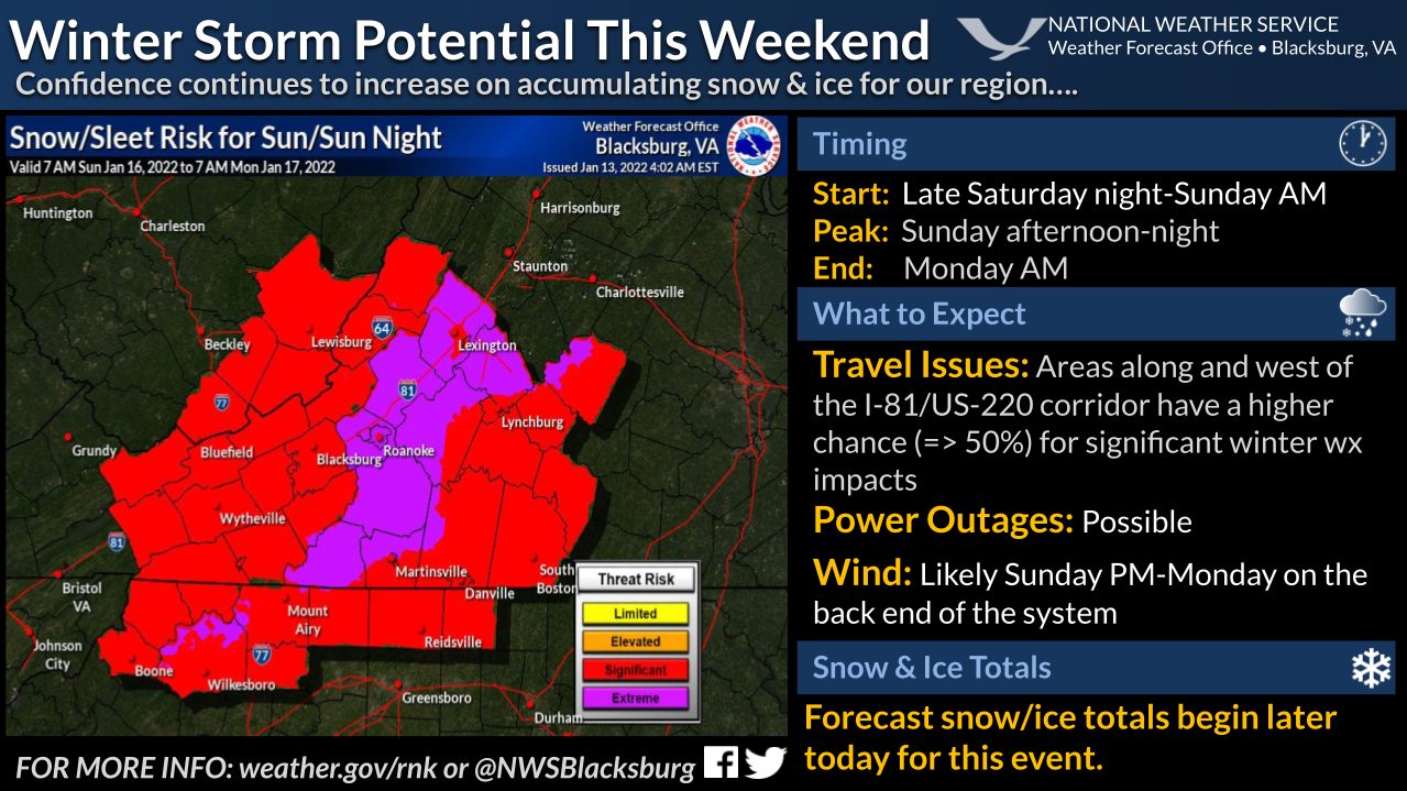
Below are updated graphics from the National Weather Service – Blacksburg with the statement “As it stands, Sunday looks to be the day with the worst impacts. This is subject to change if the storm slows down or the track changes.”
Here's the latest as of 6:40 am Thursday, January 13, 2022:
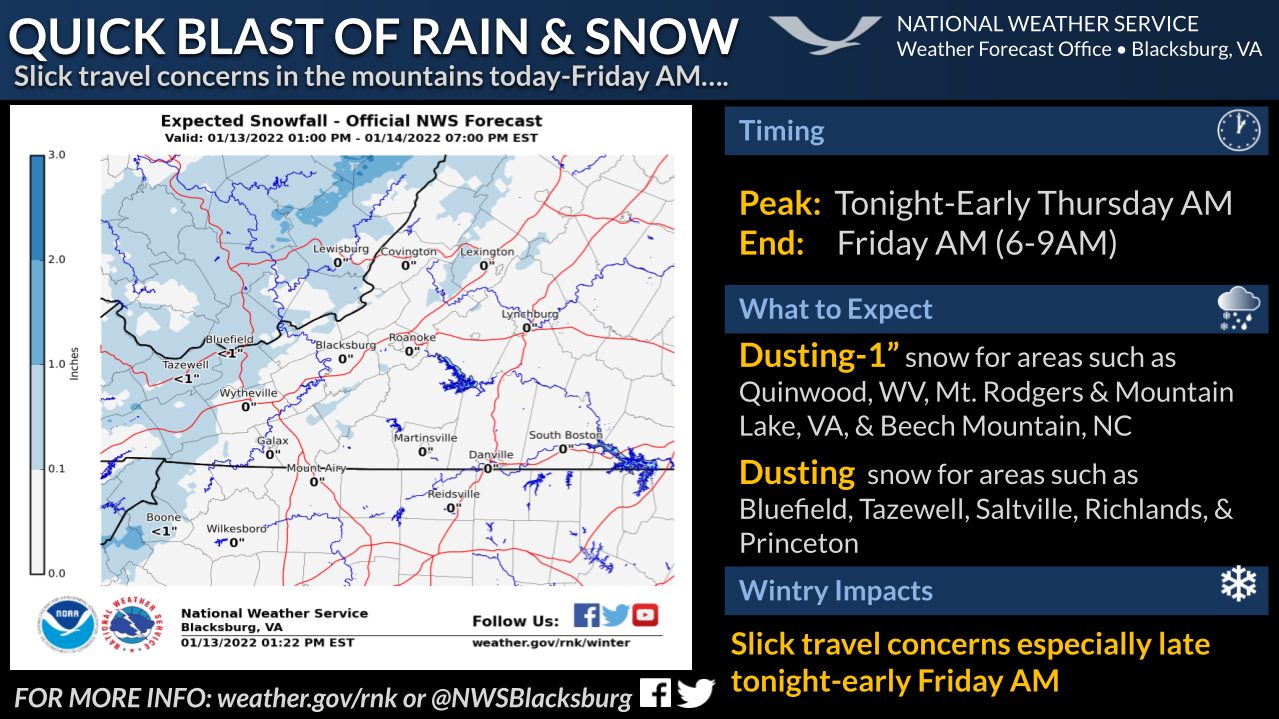
The NWS map below the Wednesday night update has been updated to reflect the expected snowfall from 1 pm Thursday to 7pm Friday.
Here's the latest as of 6:57 pm Wednesday, January 12, 2022:
The first of the two expected events will be on Thursday night into Friday. The National Weather Service (NWS) says that upslope snow showers will bring minor snowfall accumulation to the higher elevations of the North Carolina mountains. Snowfall amounts are expected to be light in general but the higher elevation areas like Beech Mountain could get between 1 to 2 inches, according to NWS. Gusty winds will also be a factor, with forecast gusts up to 30 mph on Thursday night and Friday, up to 25 mph on Friday night.
The below graphic is from NWS Blacksburg and is valid from 1 pm Thursday, January 13 through 7 pm Friday, January 14.
Wind chill values are expected to be as low as 10 above on Saturday night, as low as 5 above Sunday, as low as 10 above Sunday night and Monday and as low as 5 above Monday night and Tuesday.
The bigger focus is toward the second event which could bring substantial snow, but it's a tricky setup. That storm, for now, is expected to produce the majority of the precipitation Sunday into Sunday night. As of this update, it is too early to pinpoint what the main precipitation type might be or exact amounts. NWS says small shifts in the storm track and temperatures can result in changes in type and amounts.
Areas off the mountain could also see significant snow or freezing precipitation. Keep that in mind if you have travel plans in the Carolinas or the southeast.
WataugaOnline.com will continue to provide timely updates as more information becomes clear regarding the weekend storm.
Graphic: NWS Blacksburg – January 12, 2022
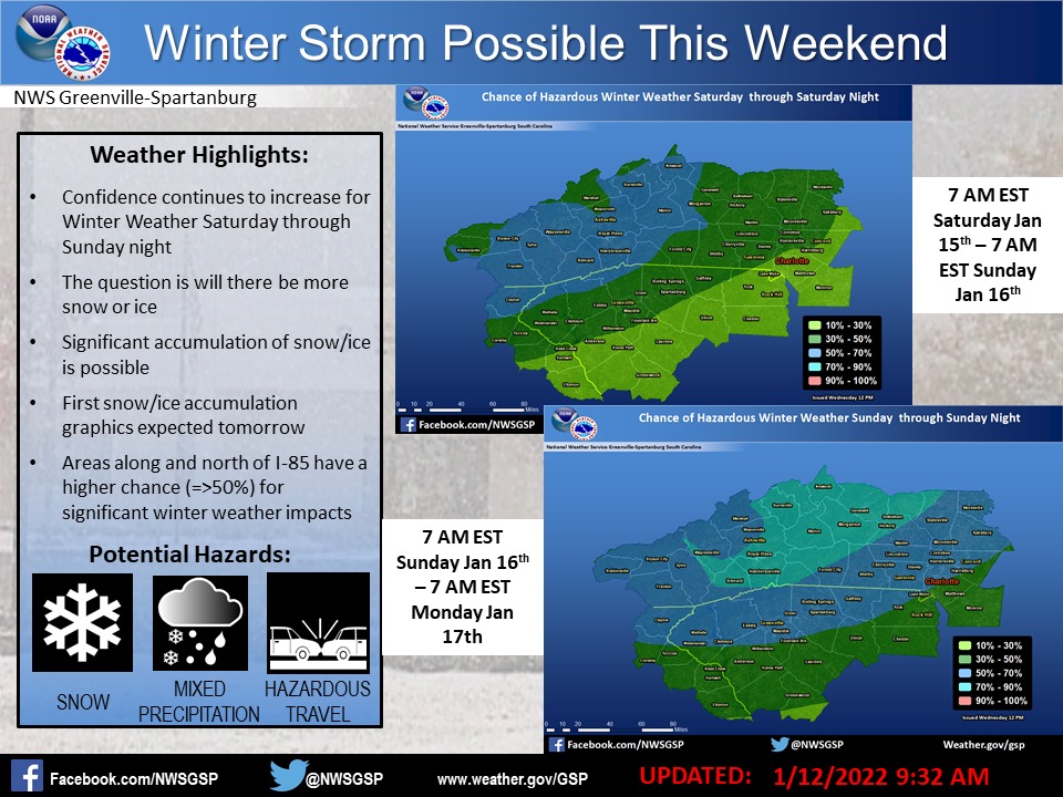
Graphic: NWS Greenville-Spartanburg – January 12, 2022
Video update on Wednesday morning from Brad Panovich Chief Meteorologist NBC Charlotte