Last Updated on January 13, 2022 3:43 pm
GAZ010-017-NCZ033-048>053-058-059-062>065-501-503-505-507-509-
SCZ001>003-140445-
/O.NEW.KGSP.WS.A.0001.220115T2300Z-220117T1300Z/
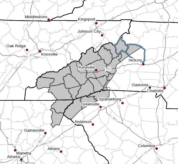
Rabun-Habersham-Avery-Madison-Yancey-Mitchell-Swain-Haywood-
Buncombe-Graham-Northern Jackson-Macon-Southern Jackson-
Transylvania-Henderson-Caldwell Mountains-Burke Mountains-
McDowell Mountains-Rutherford Mountains-Polk Mountains-
Oconee Mountains-Pickens Mountains-Greenville Mountains-
Including the cities of Clayton, Pine Mountain, Mountain City,
Cornelia, Demorest, Clarkesville, Hollywood, Ingalls, Banner Elk,
Newland, Faust, Mars Hill, Marshall, Walnut, Allenstand,
Hot Springs, Luck, Swiss, Burnsville, Celo, Micaville,
Ramseytown, Busick, Spruce Pine, Poplar, Alarka, Almond,
Bryson City, Luada, Wesser, Waynesville, Waterville, Canton,
Cruso, Cove Creek, Asheville, Robbinsville, Stecoah, Cullowhee,
Tuckasegee, Sylva, Franklin, Rainbow Springs, Kyle, Highlands,
Wolf Mountain, Cashiers, Brevard, Cedar Mountain, Little River,
Hendersonville, Fletcher, Dana, East Flat Rock, Tuxedo, Etowah,
Jonas Ridge, Ashford, Woodlawn, Old Fort,
Chimney Rock State Park, Saluda, Mountain Rest, Walhalla,
Pumpkintown, Tigerville, Gowensville, Cleveland,
and Slater-Marietta
338 PM EST Thu Jan 13 2022
…WINTER STORM WATCH IN EFFECT FROM SATURDAY EVENING THROUGH
MONDAY MORNING…
- WHAT…Heavy mixed precipitation possible. Total snow
accumulations of 6 to 10 inches across the mountain valleys and
extreme northeast Georgia, 8 to 12 inches along and near the
Blue Ridge Escarpment, and upwards of 12 to 20 inches at
elevations above 4000 feet, and ice accumulations of around one
tenth of an inch possible. - WHERE…Portions of upstate South Carolina, northeast Georgia
and western North Carolina. - WHEN…From Saturday evening through Monday morning.
- IMPACTS…Travel could be very difficult to impossible. The
hazardous conditions could impact the morning commute. - ADDITIONAL DETAILS…Precipitation may begin as early as
Saturday afternoon across parts of the mountains, and will
increase in coverage and intensity late Saturday night with a
changeover to all snow in most places. Most of the precipitation
will fall as snow across the mountains and foothills of North
Carolina, northeast Georgia, and Upstate South Carolina. The
precipitation will taper off Sunday afternoon and evening, but
snow will linger along the Tennessee border into Monday morning.
Widespread black ice should be expected Monday morning, and may
be a concern into the middle of the week. Later guidance may
change snow amounts and will determine when a Warning is issued.
PRECAUTIONARY/PREPAREDNESS ACTIONS…
A Winter Storm Watch means there is a potential for significant
snow, sleet, or ice accumulations that may impact travel.
Continue to monitor the latest forecasts.
Stay tuned to NOAA Weather Radio or your favorite source of
weather information for the latest updates. Additional details
can be found at www.weather.gov/gsp.