Last Updated on April 18, 2022 11:48 am
Special Weather Statement
National Weather Service Blacksburg VA
1144 AM EDT Mon Apr 18 2022
NCZ001-002-018-VAZ010>020-022>024-032>035-WVZ042>044-507-508-
182200-
Ashe-Alleghany NC-Watauga-Bland-Giles-Wythe-Pulaski-Montgomery-
Grayson-Carroll-Floyd-Craig-Alleghany VA-Bath-Roanoke-Botetourt-
Rockbridge-Patrick-Franklin-Bedford-Amherst-Mercer-Summers-Monroe-
Eastern Greenbrier-Western Greenbrier-
Including the cities of West Jefferson, Sparta, Boone, Bland,
Pearisburg, Wytheville, Radford, Pulaski, Blacksburg,
Independence, Whitetop, Troutdale, Volney, Galax, Floyd,
New Castle, Clifton Forge, Covington, Hot Springs, Roanoke,
Salem, Fincastle, Lexington, Buena Vista, Stuart, Rocky Mount,
Bedford, Amherst, Bluefield, Flat Top, Hinton, Hix, Union,
Lewisburg, White Sulphur Springs, Alderson, Quinwood, Duo,
and Rainelle
1144 AM EDT Mon Apr 18 2022
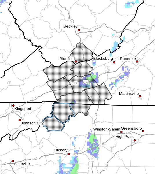
A winter weather advisory is in effect for the higher elevations
north of Interstate 64 today for accumulating snow, sleet, and
freezing rain. Farther south, mixed precipitation is possible but
little accumulation is expected. Higher elevations, such as the
Blue Ridge Parkway north of Roanoke, and ridge tops, such as
Mountain Lake and Peters Mountain, may experience temperatures
near, or just below freezing, allowing for some icing in the
trees. An inch or two of snow and sleet is also possible for the
Wilderness area in northern Amherst County. Roads may become slick
anywhere wintry precipitation falls. If you are traveling, please
use extra caution.