Last Updated on May 6, 2022 6:11 pm
NCC011-121-199-062245-
/O.NEW.KGSP.SV.W.0047.220506T2206Z-220506T2245Z/
BULLETIN – IMMEDIATE BROADCAST REQUESTED
Severe Thunderstorm Warning
National Weather Service Greenville-Spartanburg SC
606 PM EDT Fri May 6 2022
The National Weather Service in Greenville-Spartanburg has issued a
- Severe Thunderstorm Warning for…
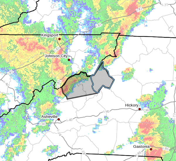
Mitchell County in western North Carolina…
Avery County in western North Carolina…
Yancey County in western North Carolina… - Until 645 PM EDT.
- At 605 PM EDT, a severe thunderstorm was located 6 miles northwest
of Burnsville, moving east at 45 mph.
HAZARD…60 mph wind gusts and penny size hail.
SOURCE…Radar indicated.
IMPACT…Expect damage to trees and power lines.
- Locations impacted include…
Spruce Pine, Burnsville, Newland, Banner Elk, Elk Park,
Bakersville, Beech Mountain In Avery County, Crossnore, Sugar
Mountain and Linville Falls.
PRECAUTIONARY/PREPAREDNESS ACTIONS…
A Tornado Watch remains in effect until 800 PM EDT for western North
Carolina.
For your protection move to an interior room on the lowest floor of a
building.
Please report damaging winds, hail, or flooding to the National
Weather Service by calling toll free, 1, 800, 2 6 7, 8 1 0 1, or by
posting on our Facebook page, or Tweet it using hashtag nwsgsp. Your
message should describe the event and the specific location where it
occurred.