Last Updated on March 1, 2025 9:22 am
…DANGEROUS CONDITIONS FOR THE SPREAD OF WILDFIRES POSSIBLE THROUGH THIS EVENING… .Low humidity and breezy, shifting winds along with drying fuels will potentially support dangerous wildfire conditions.
NCZ001>006-018>020-012000-
/O.UPG.KRNK.FW.A.0001.250301T1600Z-250302T0100Z/
/O.NEW.KRNK.FW.W.0001.250301T1500Z-250302T0300Z/
Ashe-Alleghany NC-Surry-Stokes-Rockingham-Caswell-Watauga-Wilkes-
Yadkin-
238 AM EST Sat Mar 1 2025
…RED FLAG WARNING IN EFFECT FROM 10 AM THIS MORNING TO 10 PM
EST THIS EVENING FOR WIND AND LOW RELATIVE HUMIDITY FOR
NORTHWESTERN NORTH CAROLINA…
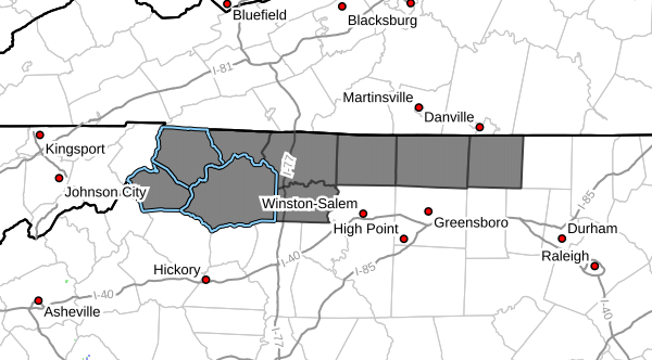
The National Weather Service in Blacksburg has issued a Red Flag
Warning for wind and low relative humidity, which is in effect
from 10 AM this morning to 10 PM EST this evening. The Fire
Weather Watch is no longer in effect.
* AFFECTED AREA…In North Carolina, Fire Weather Zone 001 Ashe,
Fire Weather Zone 002 Alleghany NC, Fire Weather Zone 003
Surry, Fire Weather Zone 004 Stokes, Fire Weather Zone 005
Rockingham, Fire Weather Zone 006 Caswell, Fire Weather Zone
018 Watauga, Fire Weather Zone 019 Wilkes and Fire Weather
Zone 020 Yadkin.
* WINDS…Northwest 10 to 20 mph with gusts up to 35 mph.
* RELATIVE HUMIDITY…As low as 22 percent.
* IMPACTS…Low humidity and breezy winds, in addition to drying
fuels, may cause any fires that develop to spread rapidly.
Outdoor burning is strongly discouraged.
PRECAUTIONARY/PREPAREDNESS ACTIONS…
A Red Flag Warning means that critical fire weather conditions
are either occurring now….or will shortly. A combination of
strong winds…low relative humidity…and warm temperatures can
contribute to extreme fire behavior.