


Last Updated on May 3, 2025 6:37 am
Hazardous Weather Outlook
National Weather Service Blacksburg VA
444 AM EDT Sat May 3 2025
NCZ001-018-VAZ007-009-010-058-059-WVZ042-043-508-040845-
Ashe-Watauga-Tazewell-Smyth-Bland-Halifax-Charlotte-Mercer-Summers-
Western Greenbrier-
444 AM EDT Sat May 3 2025
This Hazardous Weather Outlook is for northwest North Carolina,
south central Virginia, southwest Virginia and southeast West
Virginia.
.DAY ONE…Today and tonight.
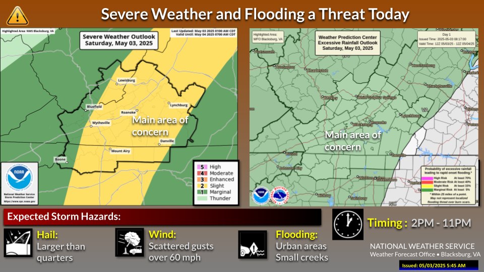
There is a Marginal Risk (Level 1 of 5) of severe thunderstorms this
afternoon into late evening. A couple of storms will be capable of
producing locally damaging winds and large hail. There is also a
Marginal Risk (Level 1 of 4) of Excessive Rainfall with these storms
that could result in localized flash flooding.
.DAYS TWO THROUGH SEVEN…Sunday through Friday.
A few storms on Sunday afternoon and evening may be capable of
producing large hail, localized damaging winds, and heavy rain that
could lead to isolated instances of flash flooding.
.SPOTTER INFORMATION STATEMENT…
Spotter activation is not expected at this time.


