Last Updated on October 28, 2021 4:33 am
Hazardous Weather Outlook
National Weather Service Blacksburg VA
340 AM EDT Thu Oct 28 2021
NCZ001>006-018>020-VAZ007-009>020-022>024-032>035-043>047-058-059-
WVZ042>044-507-508-290745-
Ashe-Alleghany NC-Surry-Stokes-Rockingham-Caswell-Watauga-Wilkes-
Yadkin-Tazewell-Smyth-Bland-Giles-Wythe-Pulaski-Montgomery-Grayson-
Carroll-Floyd-Craig-Alleghany VA-Bath-Roanoke-Botetourt-Rockbridge-
Patrick-Franklin-Bedford-Amherst-Henry-Pittsylvania-Campbell-
Appomattox-Buckingham-Halifax-Charlotte-Mercer-Summers-Monroe-
Eastern Greenbrier-Western Greenbrier-
340 AM EDT Thu Oct 28 2021
This Hazardous Weather Outlook is for north central North Carolina,
northwest North Carolina, central Virginia, south central Virginia,
southwest Virginia, west central Virginia and southeast West
Virginia.
.DAY ONE…Today and tonight.
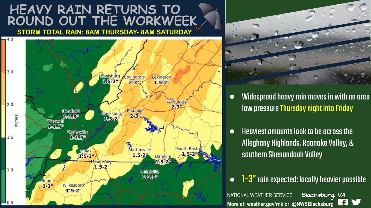
A slow, deep low pressure system will result in repeated rounds of
moderate to occasionally heavy rainfall beginning this afternoon and
continuing tonight. Rainfall amounts of 2 to 3 inches are expected
through Friday morning, especially along the Blue Ridge mountains
from near Boone, to Hillsville, to Amherst. Many trees will lose
their leaves, and this may contribute to flooding problems.
.DAYS TWO THROUGH SEVEN…Friday through Wednesday.
Widespread rains continues Friday and Saturday. Areas that see
repeated bouts of rain will see higher chances for localized
flooding.
.SPOTTER INFORMATION STATEMENT…
Spotter activation may be needed. Reports should be submitted by
phone by calling 1-866-215-4324, social media, by email at
rnk.skywarn@noaa.gov or online at www.weather.gov/rnk.