






Last Updated on September 22, 2026 7:10 pm
NCC009-189-230200-
/O.NEW.KRNK.FA.Y.0129.260922T2301Z-260923T0200Z/
/00000.N.ER.000000T0000Z.000000T0000Z.000000T0000Z.OO/
Ashe NC-Watauga NC-
701 PM EDT Tue Sep 22 2026
…FLOOD ADVISORY IN EFFECT UNTIL 10 PM EDT THIS EVENING…
* WHAT…Flooding caused by excessive rainfall is expected.
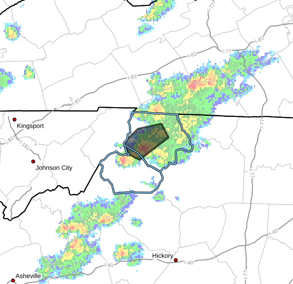
* WHERE…Northwestern Ashe County in northwestern North Carolina…
North Central Watauga County in northwestern North Carolina…
* WHEN…Until 1000 PM EDT.
* IMPACTS…Minor flooding in low-lying and poor drainage areas.
Water over roadways. Overflowing poor drainage areas.
* ADDITIONAL DETAILS…
– At 701 PM EDT, Doppler radar indicated heavy rain due to
thunderstorms. Minor flooding is ongoing or expected to begin
shortly in the advisory area. Between 1 and 2 inches of rain have
fallen.
– This includes the following streams and drainages…
Big Laurel Creek, Call Creek, North Fork New River, Meat Camp
Creek, Mill Creek, Naked Creek, Little Phoenix Creek and Hoskin
Fork. Additional rainfall amounts of 1 to 2 inches are expected
over the area. This additional rain will result in minor
flooding.
– Some locations that will experience flooding include…
Jefferson, West Jefferson, Lansing, Ashland, Clifton, Trout and
Shatley Springs.
– http://www.weather.gov/safety/flood
PRECAUTIONARY/PREPAREDNESS ACTIONS…
Turn around, don’t drown when encountering flooded roads. Most flood
deaths occur in vehicles.
Be especially cautious at night when it is harder to recognize the
dangers of flooding.
In hilly terrain there are hundreds of low water crossings which are
potentially dangerous in heavy rain. Do not attempt to cross flooded
roads. Find an alternate route.
When it is safe to do so, please send your reports of flooding,
including mudslides or flooded roads, to the National Weather Service
by calling toll free at 1…8 6 6…2 1 5…4 3 2 4. Reports and
pictures can also be shared on the National Weather Service
Blacksburg Facebook page and on X.