Last Updated on February 15, 2025 8:26 am
NCZ001-002-018-VAZ010>020-022>024-032>035-WVZ042>044-507-508-152100-
/O.NEW.KRNK.HW.A.0001.250216T1700Z-250217T1700Z/
Ashe-Alleghany NC-Watauga-Bland-Giles-Wythe-Pulaski-Montgomery-
Grayson-Carroll-Floyd-Craig-Alleghany VA-Bath-Roanoke-Botetourt-
Rockbridge-Patrick-Franklin-Bedford-Amherst-Mercer-Summers-Monroe-
Eastern Greenbrier-Western Greenbrier-
Including the cities of Salem, Rainelle, Bland, Lexington, Hix,
Pearisburg, Alderson, Radford, Blacksburg, Galax, Independence,
Sparta, Roanoke, Pulaski, Lewisburg, Troutdale, Rocky Mount,
Bluefield, Bedford, Covington, Floyd, Duo, Wytheville, Amherst,
Hinton, Boone, Buena Vista, Whitetop, Union, Hot Springs, Volney,
White Sulphur Springs, Fincastle, Stuart, New Castle, Quinwood,
Clifton Forge, Flat Top, and West Jefferson
423 AM EST Sat Feb 15 2025
…HIGH WIND WATCH IN EFFECT FROM SUNDAY AFTERNOON THROUGH MONDAY
MORNING…
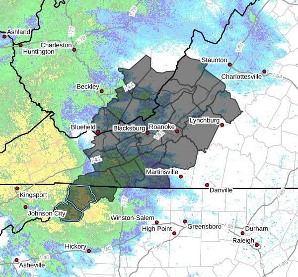
- WHAT…West winds 20 to 30 mph with gusts between 50 and 60 mph
possible. - WHERE…Portions of northwest North Carolina, central, south
central, southwest, and west central Virginia, and southeast West
Virginia. - WHEN…From Sunday afternoon through Monday morning.
- IMPACTS…Damaging winds could blow down trees and power lines.
Widespread power outages are possible. Travel could be difficult,
especially for high profile vehicles. - ADDITIONAL DETAILS…Due to the wet ground, it will be easier for
trees to be blown over. There is also extensive ice damage in some
areas with broken tree limbs, which may come down. This may also
hamper line crews from making needed repairs to power lines.
PRECAUTIONARY/PREPAREDNESS ACTIONS…
Monitor the latest forecasts and warnings for updates.
Fasten loose objects or shelter objects in a safe location prior to
the onset of winds.