Last Updated on June 19, 2023 3:19 pm
NCZ033-035-049-050-053-065-501>510-200300-
/O.NEW.KGSP.FA.A.0002.230620T1000Z-230622T2200Z/
/00000.0.ER.000000T0000Z.000000T0000Z.000000T0000Z.OO/
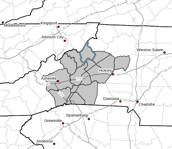
Avery-Alexander-Yancey-Mitchell-Buncombe-Henderson-Caldwell
Mountains-Greater Caldwell-Burke Mountains-Greater Burke-McDowell
Mountains-Eastern McDowell-Rutherford Mountains-Greater Rutherford-
Polk Mountains-Eastern Polk-
Including the cities of Spindale, Millersville, Sugar Hill, Nebo,
Rutherfordton, Ramseytown, Tryon, Mill Spring, Marion, Newland,
Hiddenite, Etowah, Patterson, Poplar, East Flat Rock, Dysartsville,
Morganton, Jonas Ridge, Asheville, Chimney Rock State Park, Tuxedo,
Lenoir, Fletcher, Taylorsville, Sawmills, Bethlehem, Black Mountain,
Saluda, Candler, Columbus, Glenwood, Kings Creek, Banner Elk, Celo,
Forest City, Fero, Hendersonville, Ashford, Ellendale, Pleasant
Grove, Micaville, Ingalls, Dana, Old Fort, Spruce Pine, Stony Point,
Granite Falls, Busick, Burnsville, Valdese, Woodlawn, and Swiss
249 PM EDT Mon Jun 19 2023
…FLOOD WATCH IN EFFECT FROM TUESDAY MORNING THROUGH THURSDAY
AFTERNOON…
* WHAT…Flash flooding caused by excessive rainfall is possible.
* WHERE…Portions of piedmont North Carolina and western North
Carolina, including the following areas, in piedmont North
Carolina, Alexander. In western North Carolina, Avery, Buncombe,
Burke Mountains, Caldwell Mountains, Eastern McDowell, Eastern
Polk, Greater Burke, Greater Caldwell, Greater Rutherford,
Henderson, McDowell Mountains, Mitchell, Polk Mountains,
Rutherford Mountains and Yancey.
* WHEN…From Tuesday morning through Thursday afternoon.
* IMPACTS…Excessive runoff may result in flooding of rivers,
creeks, streams, and other low-lying and flood-prone locations.
* ADDITIONAL DETAILS…
– A low pressure area dropping down over the Southeast tonight
is expected to stall to our west and southwest on Tuesday,
then linger there through the better part of the week. This
low pressure system will send periods of showers and storms
across the forecast area through at least Thursday, resulting
in widespread rainfall that may eventually cause flooding,
particularly along and near the Blue Ridge Escarpment in
North Carolina.
– http://www.weather.gov/safety/flood
PRECAUTIONARY/PREPAREDNESS ACTIONS…
A Flood Watch for flash flooding means there is a potential for
rapid onset flooding based on current forecasts. Flash flooding is a
very dangerous situation and may impact areas that do not typically
flood. Please monitor the latest forecasts and be prepared to take
action quickly should Flash Flood Warnings be issued.
Rainfall of more than five inches in similar storms has been
associated with an increased risk of landslides and rockslides. If
you live on a mountainside or in a cove at the base of a mountain,
especially near a stream, be ready to leave in advance of the storm
or as quickly as possible should rising water, moving earth, or
rocks threaten. Consider postponing travel along mountain roads
during periods of heavy rainfall.