Last Updated on March 27, 2025 6:10 pm
Flood Watch
National Weather Service Greenville-Spartanburg SC
645 PM EDT Thu Sep 26 2024
GAZ010-NCZ033-048>053-058-059-062>065-501-503-505-507-509-SCZ101>103-
270900-
/O.CON.KGSP.FA.A.0008.000000T0000Z-240927T1800Z/
/00000.0.ER.000000T0000Z.000000T0000Z.000000T0000Z.OO/
Rabun-Avery-Madison-Yancey-Mitchell-Swain-Haywood-Buncombe-Graham-
Northern Jackson-Macon-Southern Jackson-Transylvania-Henderson-
Caldwell Mountains-Burke Mountains-McDowell Mountains-Rutherford
Mountains-Polk Mountains-Oconee Mountains-Pickens Mountains-
Greenville Mountains-
Including the cities of Wesser, Highlands, East Flat Rock,
Asheville, Franklin, Cove Creek, Almond, Walnut, Patterson,
Chimney Rock State Park, Woodlawn, Luck, Allenstand, Saluda,
Ramseytown, Rainbow Springs, Brevard, Canton, Fletcher, Luada,
Marshall, Busick, Glassy Mountain, Black Mountain, Cullowhee,
Spruce Pine, Poplar, Stecoah, Sugar Hill, Pine Mountain, Mountain
City, Cruso, Faust, Waterville, Ashford, Clayton, Ingalls, Hot
Springs, Little River, Tuckasegee, Micaville, Tuxedo, Newland,
Mountain Rest, Mars Hill, Banner Elk, Sylva, Robbinsville, Wolf
Mountain, Old Fort, Kyle, Bryson City, Waynesville, Burnsville,
Candler, Etowah, Cedar Mountain, Rocky Bottom, Alarka, Cashiers,
Jonas Ridge, Swiss, Dana, Celo, and Hendersonville
645 PM EDT Thu Sep 26 2024
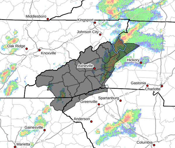
…FLOOD WATCH REMAINS IN EFFECT THROUGH FRIDAY AFTERNOON…
- WHAT…Flash flooding caused by excessive rainfall continues to be
possible. - WHERE…Portions of northeast Georgia, including the following
area, Rabun, western North Carolina, including the following
areas, Avery, Buncombe, Burke Mountains, Caldwell Mountains,
Graham, Haywood, Henderson, Macon, Madison, McDowell Mountains,
Mitchell, Northern Jackson, Polk Mountains, Rutherford Mountains,
Southern Jackson, Swain, Transylvania and Yancey, and upstate
South Carolina, including the following areas, Greenville
Mountains, Oconee Mountains and Pickens Mountains. - WHEN…Through Friday afternoon.
- IMPACTS…Excessive runoff may result in significant and damaging
flooding of rivers, creeks, streams, and other low-lying and
flood-prone locations. Areas that are not typically impacted by
floodwaters may flood. Numerous landslides are possible in areas
of steep terrain. A couple of large, damaging debris flows are
possible. - ADDITIONAL DETAILS…
- Multiple rounds of heavy rainfall are expected due to the
interaction of tropical moisture along a stationary front,
followed by the passage of Tropical Storm Helene. Additional
rainfall of 9 to 14 inches with locally higher amounts is
expected along the entire length of the Blue Ridge Escarpment
with widespread 4 to 8 inches expected across the remainder
of the mountains. This has the potential to be an extremely
rare event with dangerous catastrophic flash-flooding along
numerous streams. - http://www.weather.gov/safety/flood
PRECAUTIONARY/PREPAREDNESS ACTIONS…
A Flood Watch for flash flooding means there is a potential for
rapid onset flooding based on current forecasts. Flash flooding is a
very dangerous situation and may impact areas that do not typically
flood. Please monitor the latest forecasts and be prepared to take
action quickly should Flash Flood Warnings be issued.
Rainfall of more than five inches in similar storms has been
associated with an increased risk of landslides and rockslides. If
you live on a mountainside or in a cove at the base of a mountain,
especially near a stream, be ready to leave in advance of the storm
or as quickly as possible should rising water, moving earth, or
rocks threaten. Consider postponing travel along mountain roads
during periods of heavy rainfall.
Low-lying areas adjacent to streams, including campgrounds, are
especially vulnerable to flooding. If you live or are vacationing
next to a stream, please have a plan in place to seek higher ground
once heavy rainfall develops. Flash floods can occur quickly and
overwhelm adjacent low-lying areas with little warning. Once the
stream starts to rise, you may only have minutes to evacuate. Flash
floods can cause catastrophic damage and be powerful enough to sweep
away campers, vehicles, and mobile homes. Consider temporarily
relocating away from streams until the heavy rainfall threat passes.


