Last Updated on April 29, 2020 4:27 pm
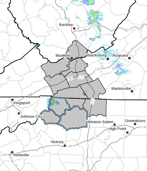
Ashe-Alleghany NC-Surry-Watauga-Wilkes-Tazewell-Smyth-Bland-Wythe- Grayson-Carroll-Mercer
Including the cities of West Jefferson, Sparta, Dobson, Boone, Wilkesboro, Tazewell, Marion, Bland, Wytheville, Independence, Whitetop, Troutdale, Volney, Galax, Bluefield, and Flat Top
312 PM EDT Wed Apr 29 2020 .
..FLOOD WATCH REMAINS IN EFFECT FROM 7 PM EDT THIS EVENING THROUGH THURSDAY MORNING…
The Flood Watch continues for
* Portions of North Carolina, southwest Virginia, and southeast West Virginia, including the following areas, in North Carolina, Alleghany NC, Ashe, Surry, Watauga, and Wilkes. In southwest Virginia, Bland, Carroll, Grayson, Smyth, Tazewell, and Wythe. In southeast West Virginia, Mercer.
* From 7 PM EDT this evening through Thursday morning
* Scattered showers and thunderstorms developing this afternoon will spread northeast during the evening. Locally heavy rainfall is possible. Then overnight, a line of thunderstorms with very heavy rainfall will cross the area from west to east. Total rainfall amounts of 2 to 3 inches, with locally higher amounts could result in flooding and/or flash flooding.
* Flash flooding will be possible in areas of heavy rainfall, especially in steep mountainous terrain. Creeks, streams, rivers, and low-lying normally flood prone areas will be subject to flooding.
PRECAUTIONARY/PREPAREDNESS ACTIONS…
A Flood Watch means there is a potential for flooding based on current forecasts.
You should monitor later forecasts and be alert for possible Flood Warnings. Those living in areas prone to flooding should be prepared to take action should flooding develop.