


Last Updated on April 11, 2024 6:00 pm
NCC009-189-193-120100-
/O.NEW.KRNK.FA.Y.0005.240411T2156Z-240412T0100Z/
/00000.N.ER.000000T0000Z.000000T0000Z.000000T0000Z.OO/
Ashe NC-Watauga NC-Wilkes NC-
556 PM EDT Thu Apr 11 2024
…FLOOD ADVISORY IN EFFECT UNTIL 9 PM EDT THIS EVENING…
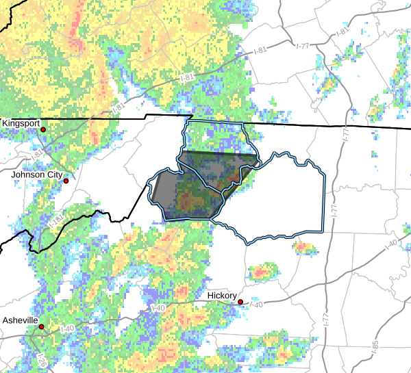
- WHAT…Flooding caused by excessive rainfall is expected.
- WHERE…A portion of northwest North Carolina, including the
following counties, Ashe, Watauga and Wilkes. - WHEN…Until 900 PM EDT.
- IMPACTS…Minor flooding in low-lying and poor drainage areas.
Dangerous flows over low-water crossings. - ADDITIONAL DETAILS…
- At 554 PM EDT, Doppler radar and automated rain gauges
indicated heavy rain. Rapid river rises will cause minor
flooding in the advisory area, especially along the Watauga
River near Sugar Grove. Between 1 and 3 inches of rain have
fallen since this morning. - This includes the following streams and drainages…
Beech Creek, Clear Branch, Dog Creek, Beaver Creek, Dutch
Creek, Craborchard Creek, Call Creek, Darnell Creek, Cove
Creek, Dugger Creek, Brushy Fork and Beaverdam Creek. - Some locations that will experience flooding include…
Boone… Jefferson…
West Jefferson… Blowing Rock…
Beech Mountain… Todd…
Deep Gap… - http://www.weather.gov/safety/flood
PRECAUTIONARY/PREPAREDNESS ACTIONS…
Turn around, don't drown when encountering flooded roads. Most flood
deaths occur in vehicles.
Stay away or be swept away. River banks and culverts can become
unstable and unsafe.
When it is safe to do so, please send your reports of flooding,
including mudslides or flooded roads, to the National Weather
Service by calling toll free at 1…8 6 6…2 1 5…4 3 2 4. Reports
and pictures can also be shared on the National Weather Service
Blacksburg Facebook page and on Twitter.


