Last Updated on August 31, 2021 8:07 am
Flood Watch
National Weather Service Blacksburg VA
435 AM EDT Tue Aug 31 2021
The remnants of Ida will move toward southwest Virginia and southern West Virginia this afternoon into Wednesday. This will bring widespread heavy rainfall this afternoon through Wednesday afternoon.
NCZ001>004-018>020-VAZ007-009>020-022>024-032>035-WVZ042>044-507-508-
311645-
/O.CON.KRNK.FF.A.0009.210831T1800Z-210902T0400Z/
/00000.0.ER.000000T0000Z.000000T0000Z.000000T0000Z.OO/
Ashe-Alleghany NC-Surry-Stokes-Watauga-Wilkes-Yadkin-Tazewell-Smyth-
Bland-Giles-Wythe-Pulaski-Montgomery-Grayson-Carroll-Floyd-Craig-
Alleghany VA-Bath-Roanoke-Botetourt-Rockbridge-Patrick-Franklin-
Bedford-Amherst-Mercer-Summers-Monroe-Eastern Greenbrier-Western
Greenbrier-
Including the cities of Roanoke, Wilkesboro, Sparta, Union, Pulaski,
Covington, Hinton, Independence, Fincastle, Buena Vista, Danbury,
Hix, Duo, Tazewell, Floyd, Bluefield, Hot Springs, Flat Top, Clifton
Forge, Rainelle, Wytheville, Yadkinville, Whitetop, Bedford, Volney,
Alderson, Pearisburg, Blacksburg, West Jefferson, Lexington,
Quinwood, Radford, Boone, Stuart, Lewisburg, New Castle, Dobson,
Rocky Mount, Galax, Salem, Marion, Amherst, Bland, White Sulphur
Springs, and Troutdale
435 AM EDT Tue Aug 31 2021
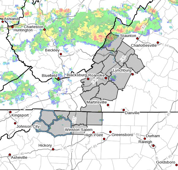
…FLASH FLOOD WATCH REMAINS IN EFFECT FROM 2 PM EDT THIS AFTERNOON
THROUGH WEDNESDAY EVENING…
The Flash Flood Watch continues for
- Portions of North Carolina, Virginia and southeast West Virginia,
including the following areas, in North Carolina, Alleghany NC,
Ashe, Stokes, Surry, Watauga, Wilkes and Yadkin. In Virginia,
Alleghany VA, Amherst, Bath, Bedford, Bland, Botetourt, Carroll,
Craig, Floyd, Franklin, Giles, Grayson, Montgomery, Patrick,
Pulaski, Roanoke, Rockbridge, Smyth, Tazewell and Wythe. In
southeast West Virginia, Eastern Greenbrier, Mercer, Monroe,
Summers and Western Greenbrier. - From 2 PM EDT this afternoon through Wednesday evening.
- Widespread heavy rain is expected first with the spiral bands of
showers and scattered thunderstorms this afternoon and evening,
then transition to a steadier moderate to occasionally heavy
rainfall Tonight into Wednesday. Widespread rainfall amounts
of 1 to 3 inches are expected with locally heavier amounts of 2 to
5 inches possible where any rain bands set up and persist over a
particular area. Localized thunderstorms could also result in high
rainfall rates in some locations. - Widespread minor flooding is expected which will impact low-lying,
poor drainage, and typically flood prone areas. Small creeks and
streams will likely rise out of their banks and flood adjacent
areas. Landslides and mudslides will also be possible in
areas of steeper terrain closer to the Blue Ridge. Some roads and
highways could become impassable as a result of mudslides and/or
stream and creek flooding.
PRECAUTIONARY/PREPAREDNESS ACTIONS…
A Flash Flood Watch means that conditions may develop that lead
to flash flooding. Flash flooding is a VERY DANGEROUS SITUATION.
Check preparedness requirements and be ready for quick action if
a Flash Flood Warning is issued or flash flooding is observed.
Seek higher ground immediately. Do not drive your vehicle into
areas where water covers the road. Remember…TURN AROUND…DON`T
DROWN!
You should monitor later forecasts and be prepared to take action
should Flash Flood Warnings be issued.