


Last Updated on February 17, 2021 6:19 am
…Significant Mix of Wintry Precipitation Expected… .A low pressure system will bring wintry precipitation across the Mid Atlantic starting tonight. Significant amounts of snow, sleet, and freezing rain are possible. The precipitation may start as a mix of snow and sleet tonight and change over to freezing rain for most locations by Thursday. Colder air could change the precipitation back to a mix of snow and sleet Thursday night.
NCZ001>003-018>020-VAZ007-009>017-022-171730-
/O.UPG.KRNK.WS.A.0006.210218T0000Z-210219T0500Z/
/O.NEW.KRNK.WS.W.0007.210218T0000Z-210219T0600Z/
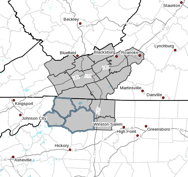
Ashe-Alleghany NC-Surry-Watauga-Wilkes-Yadkin-Tazewell-Smyth-
Bland-Giles-Wythe-Pulaski-Montgomery-Grayson-Carroll-Floyd-
Roanoke-
Including the cities of West Jefferson, Sparta, Dobson, Boone,
Wilkesboro, Yadkinville, Tazewell, Marion, Bland, Pearisburg,
Wytheville, Radford, Pulaski, Blacksburg, Independence, Whitetop,
Troutdale, Volney, Galax, Floyd, Roanoke, and Salem
425 AM EST Wed Feb 17 2021
…WINTER STORM WARNING IN EFFECT FROM 7 PM THIS EVENING TO 1 AM
EST FRIDAY…
- WHAT…Heavy mixed precipitation expected. Total snow
accumulations of 1 to 4 inches and ice accumulations of one
quarter to one half of an inch. - WHERE…Portions of southwest and west central Virginia and
north central and northwest North Carolina. - WHEN…From 7 PM this evening to 1 AM EST Friday.
- IMPACTS…Power outages and tree damage are likely due to the
snow and ice. Travel could be nearly impossible. The hazardous
conditions could impact the morning or evening commute.
PRECAUTIONARY/PREPAREDNESS ACTIONS…
If you must travel, keep an extra flashlight, food, and water in
your vehicle in case of an emergency.
Please report snow, sleet or ice accumulations via email at
rnk.skywarn@noaa.gov or by calling the National Weather Service
toll free at…1…866…2 1 5…4 3 2 4. Leave a message with
your observation and the specific location where it occurred. You
can also post your report to National Weather Service Blacksburg
Facebook page and on Twitter.
The latest road conditions for the state you are calling from can
be obtained by calling 5 1 1.


