Last Updated on February 10, 2023 2:37 pm
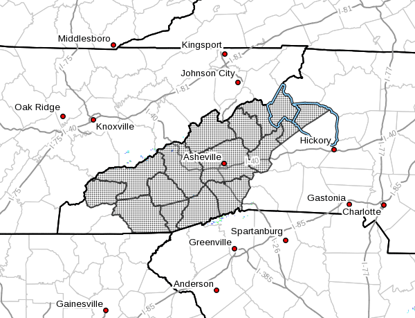
NCZ033-048>053-058-059-062>065-501-503-505-110345-
/O.NEW.KGSP.WS.A.0001.230212T0000Z-230213T0500Z/
Avery-Madison-Yancey-Mitchell-Swain-Haywood-Buncombe-Graham-
Northern Jackson-Macon-Southern Jackson-Transylvania-Henderson-
Caldwell Mountains-Burke Mountains-McDowell Mountains-
Including the cities of Ingalls, Banner Elk, Newland, Faust,
Mars Hill, Marshall, Walnut, Allenstand, Hot Springs, Luck,
Swiss, Burnsville, Celo, Micaville, Ramseytown, Busick,
Spruce Pine, Poplar, Alarka, Almond, Bryson City, Luada, Wesser,
Waynesville, Waterville, Canton, Cruso, Cove Creek, Asheville,
Black Mountain, Candler, Robbinsville, Stecoah, Cullowhee,
Tuckasegee, Sylva, Franklin, Rainbow Springs, Kyle, Highlands,
Wolf Mountain, Cashiers, Brevard, Cedar Mountain, Little River,
Hendersonville, Fletcher, Dana, East Flat Rock, Tuxedo, Etowah,
Jonas Ridge, Ashford, Woodlawn, and Old Fort
234 PM EST Fri Feb 10 2023
…WINTER STORM WATCH IN EFFECT FROM SATURDAY EVENING THROUGH
SUNDAY EVENING…
* WHAT…Heavy mixed precipitation possible. Total snow and sleet
accumulations of 4 to 10 inches and ice accumulations of a light
glaze possible. Winds could gust as high as 40 mph.
* WHERE…The North Carolina mountains.
* WHEN…From Saturday evening through Sunday evening.
* IMPACTS…Travel could be very difficult. Heavy snow and gusty
winds could combine to knock down some trees and power lines.
* ADDITIONAL DETAILS…Precipitation may start out as a mix of
sleet and freezing rain Saturday night, before changing over to
mainly snow by daybreak Sunday. Snow will taper off Sunday
evening, and temperatures will fall below freezing Sunday night.
The heaviest snow accumulations will be in elevations above
3500 ft. There is more uncertainty on snowfall in the valleys.
PRECAUTIONARY/PREPAREDNESS ACTIONS…
A Winter Storm Watch means there is a potential for significant
snow, sleet, or ice accumulations that may impact travel.
Continue to monitor the latest forecasts.
Stay tuned to NOAA Weather Radio or your favorite source of
weather information for the latest updates. Additional details
can be found at www.weather.gov/gsp.