


Last Updated on December 23, 2020 3:01 pm
…ARCTIC FRONT TO USHER IN VERY COLD AIR AND RAPID CHANGE TO SHOW IN THE MOUNTAINS THURSDAY EVENING… .A strong arctic front will pass through the Appalachians late Thursday and overnight, causing a rapid drop in temperatures to below freezing, a change from rain to snow, which may be heavy at times, as well as wet roads icing up quickly resulting in a flash freeze in some areas. In addition, gusty west winds will result in areas of blowing snow and wind chills will drop into the single digits in many areas to below zero on higher ridges.
NCZ001-018-VAZ009-015-240400-
/O.NEW.KRNK.WS.W.0005.201224T2100Z-201225T1100Z/
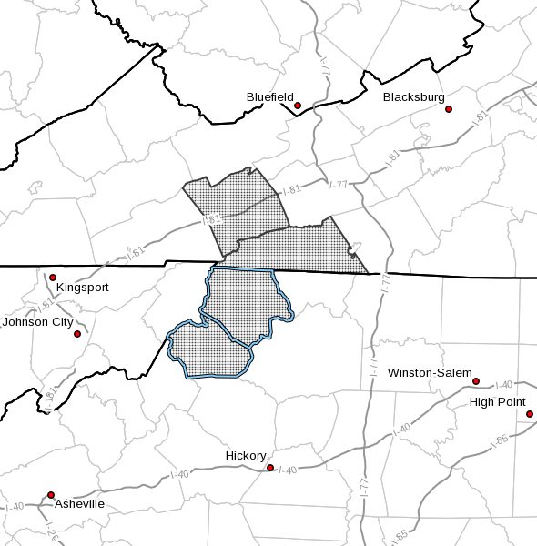
Ashe-Watauga-Smyth-Grayson-
Including the cities of West Jefferson, Boone, Marion,
Independence, Whitetop, Troutdale, and Volney
251 PM EST Wed Dec 23 2020
…WINTER STORM WARNING IN EFFECT FROM 4 PM THURSDAY TO 6 AM EST
FRIDAY…
- WHAT…Moderate to at times heavy snow expected. Total snow
accumulations of 2 to 4 inches. Winds gusting as high as 45 mph. - WHERE…In Virginia, Smyth and western Grayson Counties. In
North Carolina, Ashe and Watauga Counties. - WHEN…From 4 PM Thursday to 6 AM EST Friday.
- IMPACTS….Travel could be very difficult as snow accumulates,
blows around, and untreated roads ice up quickly. The cold wind
chills from around zero to single digits could result in
hypothermia if precautions are not taken. - ADDITIONAL DETAILS…Winds will gust to 35 or 40 mph on higher
ridges, causing blowing and drifting snow and wind chills of
zero to 5 below zero by early Friday.
PRECAUTIONARY/PREPAREDNESS ACTIONS…
If you must travel, keep an extra flashlight, food, and water in
your vehicle in case of an emergency.
The latest road conditions for the state you are calling from can
be obtained by calling 5 1 1.


