


Last Updated on January 7, 2021 5:27 am
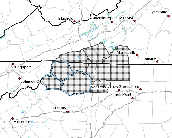
…Snow expected for North Carolina and Southern Virginia… Low pressure moving across the deep south will approach the region from the southwest late tonight. The low will move east across the Carolinas through Friday evening. This will bring a period of accumulating snow for parts of North Carolina and southern Virginia.
NCZ001>004-018>020-VAZ015-016-032-071715-
/O.UPG.KRNK.WS.A.0001.210108T0000Z-210109T0500Z/
/O.NEW.KRNK.WS.W.0001.210108T0500Z-210109T0500Z/
Ashe-Alleghany NC-Surry-Stokes-Watauga-Wilkes-Yadkin-Grayson-
Carroll-Patrick-
Including the cities of West Jefferson, Sparta, Dobson, Danbury,
Boone, Wilkesboro, Yadkinville, Independence, Whitetop,
Troutdale, Volney, Galax, and Stuart
410 AM EST Thu Jan 7 2021
…WINTER STORM WARNING IN EFFECT FROM MIDNIGHT TONIGHT TO
MIDNIGHT EST FRIDAY NIGHT…
- WHAT…Heavy wet snow expected. Total snow accumulations of 3 to
6 inches. - WHERE…Portions of southwest Virginia and northwest North
Carolina. - WHEN…From midnight tonight to midnight EST Friday night.
- IMPACTS…Travel could be difficult especially in the higher
elevations. The hazardous conditions may impact the morning or
evening commute. - ADDITIONAL DETAILS…Expect temperatures between 28 and 34
degrees.
PRECAUTIONARY/PREPAREDNESS ACTIONS…
Once the snow begins, slow down and use caution while traveling.
The latest road conditions for the state you are calling from can
be obtained by calling 5 1 1.


