Last Updated on January 2, 2022 6:18 pm
URGENT – WINTER WEATHER MESSAGE
National Weather Service Greenville-Spartanburg SC
358 PM EST Sun Jan 2 2022
NCZ033-048>050-052-030500-
/O.CON.KGSP.WS.W.0001.220103T0300Z-220103T1700Z/
Avery-Madison-Yancey-Mitchell-Haywood-
Including the cities of Ingalls, Banner Elk, Newland, Faust,
Mars Hill, Marshall, Walnut, Allenstand, Hot Springs, Luck,
Swiss, Burnsville, Celo, Micaville, Ramseytown, Busick,
Spruce Pine, Poplar, Waynesville, Waterville, Canton, Cruso,
and Cove Creek
358 PM EST Sun Jan 2 2022
…WINTER STORM WARNING REMAINS IN EFFECT FROM 10 PM THIS EVENING
TO NOON EST MONDAY…
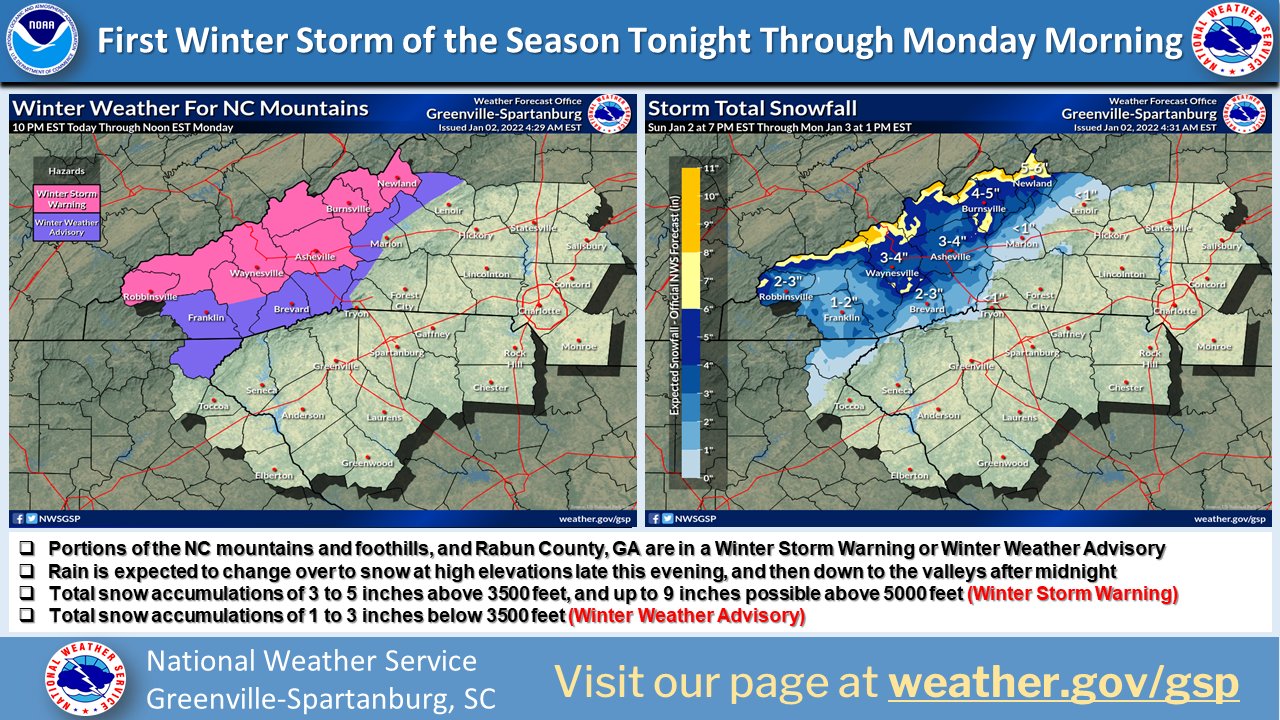
- WHAT…Heavy snow expected. Total snow accumulations of 4 to 8
inches, with some 10 to 12 inch amounts at the higher peaks near
the Tennessee border. Winds gusting as high as 50 mph. - WHERE…Haywood, Mitchell, Madison, Avery and Yancey Counties.
- WHEN…From 10 PM this evening to noon EST Monday.
- IMPACTS…Travel could be very difficult. The hazardous
conditions could impact the morning commute. The winds may blow
down tree limbs and cause scattered power outages. - ADDITIONAL DETAILS…Rain is expected to change over to snow at
high elevations late this evening, and then down to the valleys
overnight. Although the ground is relatively warm because of the
recent warm temperatures, the snow is expected to fall at high
rates and accumulate even on roads. The snow should taper off
from the west Monday morning. Slippery roads and black ice
conditions could persist or redevelop well into Tuesday morning.
PRECAUTIONARY/PREPAREDNESS ACTIONS…
A Winter Storm Warning for heavy snow means severe winter weather
conditions are expected or occurring. Significant amounts of snow
are forecast that will make travel dangerous. Only travel in an
emergency. If you must travel, keep a flashlight, food, water,
and a warm blanket in your vehicle in case of an emergency.
Please report snow and ice accumulations by calling the National
Weather Service toll free at…1…800…2 6 7…8 1 0 1. Leave a
message with your observation and the specific location where it
occurred. You can also post your report to National Weather
Service Greenville Spartanburg Facebook or tweet your report
using hashtag nwsgsp.
Stay tuned to NOAA Weather Radio or your favorite source of
weather information for the latest updates. Additional details
can be found at www.weather.gov/gsp. The latest state road
conditions can be obtained by calling 5 1 1.