


Last Updated on September 29, 2022 11:44 am
Tropical Storm Ian Local Statement Advisory Number 28
National Weather Service Greenville-Spartanburg SC AL092022
1138 AM EDT Thu Sep 29 2022
This product covers the western Carolinas and Northeast Georgia
STRONG GUSTY WINDS AND HEAVY RAIN EXPECTED TO IMPACT PARTS OF THE PIEDMONT OF THE CAROLINAS BEGINNING LATE TONIGHT
NEW INFORMATION
- CHANGES TO WATCHES AND WARNINGS:
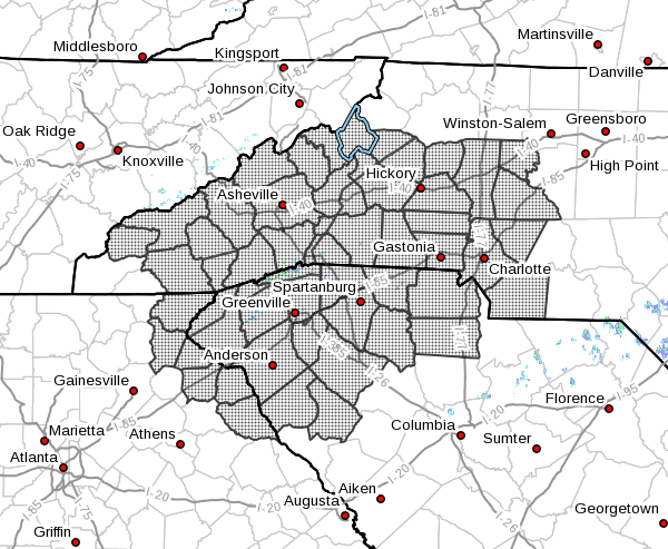
- A Tropical Storm Warning has been issued for Cabarrus, Catawba,
Chester, Davie, Gaston, Iredell, Lincoln, Mecklenburg, Rowan,
Union NC, and York - CURRENT WATCHES AND WARNINGS:
- A Tropical Storm Warning is in effect for Cabarrus, Catawba,
Chester, Davie, Gaston, Iredell, Lincoln, Mecklenburg, Rowan,
Union NC, and York - STORM INFORMATION:
- About 450 miles south of Charlotte NC or about 490 miles south
of Hickory NC - 28.7N 80.4W
- Storm Intensity 70 mph
- Movement North-northeast or 30 degrees at 9 mph
SITUATION OVERVIEW
Tropical Storm Ian is expected to strengthen back into a
hurricane before making landfall again in South Carolina. It will
track northwest across the Carolinas, bringing strong winds and heavy
rain to the region. Localized flash flooding will be possible with the
heavy rain.
POTENTIAL IMPACTS
- WIND:
Protect against hazardous wind having possible limited impacts across
the western Carolinas and NE Georgia. Potential impacts include: - Damage to porches, awnings, carports, sheds, and unanchored
mobile homes. Unsecured lightweight objects blown about. - Many large tree limbs broken off. A few trees snapped or
uprooted, but with greater numbers in places where trees are
shallow rooted. Some fences and roadway signs blown over. - A few roads impassable from debris, particularly within urban
or heavily wooded places. Hazardous driving conditions on
bridges and other elevated roadways. - Scattered power and communications outages.
- FLOODING RAIN:
Protect against life-threatening rainfall flooding having possible
extensive impacts across the northern Upstate, and the western Piedmont,
foothills, and northern and central mountains of North Carolina. Potential
impacts include: - Major rainfall flooding may prompt many evacuations and rescues.
- Rivers and tributaries may rapidly overflow their banks in
multiple places. Small streams, creeks, canals, arroyos, and
ditches may become dangerous rivers. In mountain areas,
destructive runoff may run quickly down valleys while
increasing susceptibility to rockslides and mudslides. Flood
control systems and barriers may become stressed. - Flood waters can enter many structures within multiple
communities, some structures becoming uninhabitable or washed
away. Many places where flood waters may cover escape routes.
Streets and parking lots become rivers of moving water with
underpasses submerged. Driving conditions become dangerous.
Many road and bridge closures with some weakened or washed out.
Protect against dangerous rainfall flooding having possible
significant impacts across the western Upstate of South Carolina and
parts of the southern mountains of North Carolina.
- TORNADOES:
Little to no impacts are anticipated at this time
across the western Carolinas and northeast Georgia.
PRECAUTIONARY/PREPAREDNESS ACTIONS
- OTHER PREPAREDNESS INFORMATION:
Now is the time to complete all preparations to protect life and
property in accordance with your emergency plan. Ensure you are in a
safe location before the onset of strong winds or possible flooding.
Keep cell phones well charged. Cell phone chargers for automobiles
can be helpful, but be aware of your risk for deadly carbon monoxide
poisoning if your car is left idling in a garage or other poorly
ventilated area.
If you are a visitor, be sure to know the name of the city or town in
which you are staying and the name of the county or parish in which
it resides. Listen for these locations in local news updates. Pay
attention for instructions from local authorities.
Closely monitor weather.gov, NOAA Weather radio or local news outlets
for official storm information. Be ready to adapt to possible changes
to the forecast. Ensure you have multiple ways to receive weather
warnings.
- ADDITIONAL SOURCES OF INFORMATION:
- For information on appropriate preparations see ready.gov
- For information on creating an emergency plan see getagameplan.org
- For additional disaster preparedness information see redcross.org
NEXT UPDATE
The next local statement will be issued by the National Weather
Service in Greenville-Spartanburg SC around 6 PM EDT, or sooner if
conditions warrant.


