Last Updated on January 12, 2023 3:29 pm
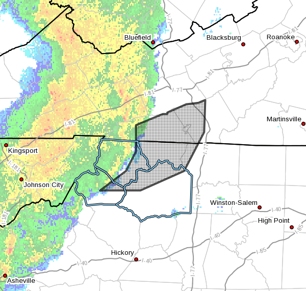
Radar valid at 326 pm EST, Jan 12th 2023

NCZ001>003-018-019-VAZ015-016-122100-
Surry NC-Ashe NC-Wilkes NC-Watauga NC-Alleghany NC-Grayson VA-
Carroll VA-
325 PM EST Thu Jan 12 2023
…Strong thunderstorms will impact portions of
Alleghany, northwestern Surry, northern Wilkes, east central Watauga
and eastern Ashe Counties in northwestern North Carolina, western
Carroll and Grayson Counties in southwestern Virginia and the City of
Galax through 400 PM EST…
At 325 PM EST, Doppler radar was tracking strong thunderstorms along
a line extending from near Bridle Creek to Scottville to Wagoner to
Deep Gap. Movement was east at 55 mph.
HAZARD…Winds in excess of 40 mph.
SOURCE…Radar indicated.
IMPACT…Gusty winds could knock down tree limbs and blow around
unsecured objects.
Locations impacted include…
Boone…
Galax…
Hillsville…
Sparta…
Independence…
Fries…
and Traphill.
PRECAUTIONARY/PREPAREDNESS ACTIONS…
If outdoors, consider seeking shelter inside a building.