


Last Updated on August 29, 2023 12:58 pm
NCZ001-002-018-019-291730-
Ashe NC-Wilkes NC-Watauga NC-Alleghany NC-
1251 PM EDT Tue Aug 29 2023
…A STRONG THUNDERSTORM WILL IMPACT
SOUTHWESTERN ALLEGHANY…WILKES…EASTERN WATAUGA AND ASHE COUNTIES
IN NORTHWESTERN NORTH CAROLINA THROUGH 130 PM EDT…
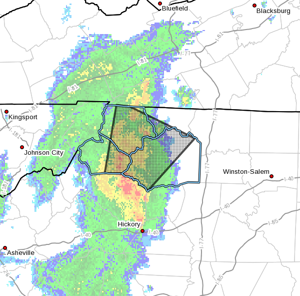
At 1251 PM EDT, Doppler radar was tracking a strong thunderstorm over
Darby, or 7 miles south of Deep Gap, moving northeast at 35 mph.
HAZARD…Wind gusts up to 40 mph.
SOURCE…Radar indicated.
IMPACT…Gusty winds could knock down tree limbs and blow around
unsecured objects.
Locations impacted include…
Boone…
North Wilkesboro…
Wilkesboro…
Jefferson…
West Jefferson…
Blowing Rock…
and Lansing.
PRECAUTIONARY/PREPAREDNESS ACTIONS…
If outdoors, consider seeking shelter inside a building.
Locally heavy rain will quickly reduce visibility and result in
ponding of water on roadways, standing water in low lying areas, and
minor flooding of creeks, streams, and areas of poor drainage.
Drivers are urged to slow down and use extra caution to avoid
hydroplaning.


