Last Updated on March 29, 2024 11:04 am
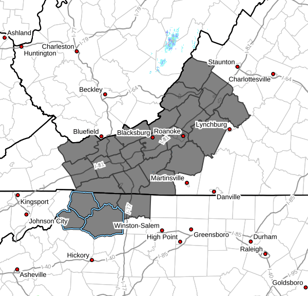
NCZ001>003-018-019-VAZ007-009>020-022>024-032>035-292230-
Ashe-Alleghany NC-Surry-Watauga-Wilkes-Tazewell-Smyth-Bland-Giles-
Wythe-Pulaski-Montgomery-Grayson-Carroll-Floyd-Craig-Alleghany VA-
Bath-Roanoke-Botetourt-Rockbridge-Patrick-Franklin-Bedford-
Amherst-
Including the cities of West Jefferson, Sparta, Dobson, Boone,
Wilkesboro, Tazewell, Marion, Bland, Pearisburg, Wytheville,
Radford, Pulaski, Blacksburg, Independence, Whitetop, Troutdale,
Volney, Galax, Floyd, New Castle, Clifton Forge, Covington,
Hot Springs, Roanoke, Salem, Fincastle, Lexington, Buena Vista,
Stuart, Rocky Mount, Bedford, and Amherst
1059 AM EDT Fri Mar 29 2024
…ELEVATED FIRE DANGER THIS AFTERNOON AND EARLY EVENING…
Dry and windy conditions are expected this afternoon from the
from the mountains to the Blue Ridge foothills…including the
New River, Roanoke, and Shenandoah Valleys. Relative humidity
values are expected to drop under 30 percent associated with
strong northwest winds of around 15 to 25 mph, with gusts of 30 to
50 mph. This will result in the continued rapid drying of leaf
litter and other forest fuels.
Residents and visitors are urged to exercise caution if handling
open flames or equipment that creates sparks. Also, dispose of
cigarette butts, matches, and other flammable items in appropriate
containers. Keep vehicles off of dry grass and obey local burn bans.
Most dry grasses, dead leaves, and other tree litter could easily
ignite and spread fire quickly.
For more information about wildfire danger, burn restrictions,
and wildfire prevention and education, please visit your state's
forestry or environmental protection website.