


Last Updated on February 21, 2021 6:03 pm
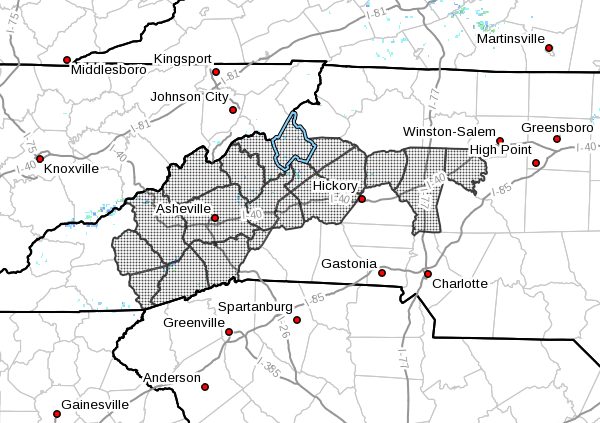
NCZ033-035>037-048>050-052-053-059-063>065-501>507-220400-
Avery-Alexander-Iredell-Davie-Madison-Yancey-Mitchell-Haywood-
Buncombe-Northern Jackson-Southern Jackson-Transylvania-Henderson-
Caldwell Mountains-Greater Caldwell-Burke Mountains-Greater Burke-
McDowell Mountains-Eastern McDowell-Rutherford Mountains-
Including the cities of Ingalls, Banner Elk, Newland, Bethlehem,
Ellendale, Millersville, Taylorsville, Hiddenite, Stony Point,
Statesville, Mooresville, Farmington, Fork Church, Mocksville,
Advance, Faust, Mars Hill, Marshall, Walnut, Allenstand,
Hot Springs, Luck, Swiss, Burnsville, Celo, Micaville,
Ramseytown, Busick, Spruce Pine, Poplar, Waynesville, Waterville,
Canton, Cruso, Cove Creek, Asheville, Black Mountain, Candler,
Cullowhee, Tuckasegee, Sylva, Wolf Mountain, Cashiers, Brevard,
Cedar Mountain, Little River, Hendersonville, Fletcher, Dana,
East Flat Rock, Tuxedo, Etowah, Patterson, Kings Creek, Lenoir,
Sawmills, Granite Falls, Jonas Ridge, Morganton, Pleasant Grove,
Valdese, Ashford, Sugar Hill, Woodlawn, Old Fort, Marion, Nebo,
Dysartsville, Fero, Glenwood, and Chimney Rock State Park
237 PM EST Sun Feb 21 2021
…A BRIEF WINTRY MIX EXPECTED ACROSS PORTIONS OF WESTERN NORTH
CAROLINA LATE TONIGHT AND MONDAY MORNING…
Precipitation is expected to overspread western North Carolina
from the southwest beginning around midnight and continuing into
the daylight hours Monday. Locations across the mountains, as well
as along and north of the I-40 corridor in the Piedmont and
foothills are expected to be around freezing when the
precipitation begins. This could result in a brief period of a
wintry mix, with freezing rain likely being the most prevalent
precipitation type. Spotty light accumulations of ice and perhaps
sleet are possible across the area. Locations that do see
freezing rain are likely to see ice accumulations from trace
amounts to only a few hundreths of an inch, mainly on elevated
surfaces such as trees and power lines. Locally higher amounts are
possible, especially along the Blue Ridge escarpment. Widespread
travel issues are not expected due to relatively warm road
temperatures, but a few slick spots could develop on bridges and
overpasses.
At this time, temperatures are expected to warm above freezing
after sunrise Monday, but if later information indicates
temperatures will be slower to warm than currently expected, a
Winter Weather Advisory may become necessary later today or
tonight.


