Last Updated on July 29, 2023 5:46 pm
NCC011-021-115-121-199-292230-
/O.NEW.KGSP.SV.W.0213.230729T2139Z-230729T2230Z/
BULLETIN – IMMEDIATE BROADCAST REQUESTED
Severe Thunderstorm Warning
National Weather Service Greenville-Spartanburg SC
539 PM EDT Sat Jul 29 2023
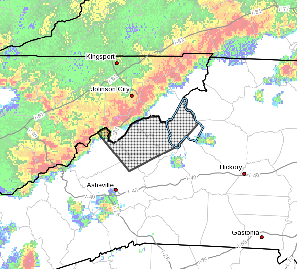
The National Weather Service in Greenville-Spartanburg has issued a
* Severe Thunderstorm Warning for…
Northeastern Madison County in western North Carolina…
Mitchell County in western North Carolina…
Avery County in western North Carolina…
North central Buncombe County in western North Carolina…
Yancey County in western North Carolina…
* Until 630 PM EDT.
* At 539 PM EDT, severe thunderstorms were located in East
Tennessee, along a line extending from 10 miles west of Mountain
City to 7 miles northeast of Erwin to 11 miles southeast of
Greeneville TN, moving southeast at 25 mph.
HAZARD…60 mph wind gusts.
SOURCE…Radar indicated.
IMPACT…Expect damage to trees and power lines.
* Locations impacted include…
Spruce Pine, Burnsville, Newland, Banner Elk, Elk Park,
Bakersville, Beech Mountain In Avery County, Crossnore, Sugar
Mountain and Linville Falls.
PRECAUTIONARY/PREPAREDNESS ACTIONS…
For your protection move to an interior room on the lowest floor of a
building.
Please report damaging winds, hail, or flooding to the National
Weather Service by calling toll free, 1, 800, 2 6 7, 8 1 0 1, or by
posting on our Facebook page, or Tweet it using hashtag nwsgsp. Your
message should describe the event and the specific location where it
occurred.