Last Updated on January 12, 2023 1:55 pm
BULLETIN – IMMEDIATE BROADCAST REQUESTED
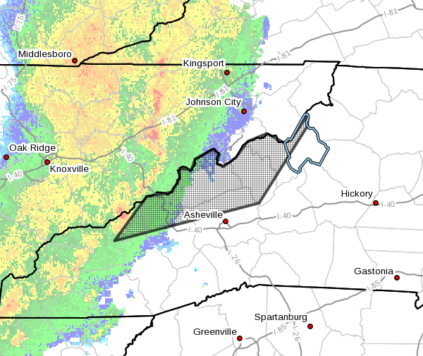
Severe Thunderstorm Warning
National Weather Service Greenville-Spartanburg SC
144 PM EST Thu Jan 12 2023
The National Weather Service in Greenville-Spartanburg has issued a
- Severe Thunderstorm Warning for…
Madison County in western North Carolina…
Northeastern Swain County in western North Carolina…
Mitchell County in western North Carolina…
Northwestern Avery County in western North Carolina…
Northern Haywood County in western North Carolina…
Northern Buncombe County in western North Carolina…
Yancey County in western North Carolina… - Until 245 PM EST.
- At 144 PM EST, severe thunderstorms were located along a line
extending from 10 miles northwest of Greeneville to 16 miles east
of Newport to 8 miles northeast of Bryson City, moving east at 60
mph.
HAZARD…70 mph wind gusts.
SOURCE…Radar indicated.
IMPACT…Expect considerable tree damage. Damage is likely to
mobile homes, roofs, and outbuildings.
- Locations impacted include…
Burnsville, Marshall, Weaverville, Mars Hill, Hot Springs, Elk
Park, Bakersville, Smoky Mountains-Balsam Mountain, Smoky
Mountains-Big Creek and Smoky Mountains-Cataloochee.
PRECAUTIONARY/PREPAREDNESS ACTIONS…
For your protection move to an interior room on the lowest floor of a
building.
Please report damaging winds, hail, or flooding to the National
Weather Service by calling toll free, 1, 800, 2 6 7, 8 1 0 1, or by
posting on our Facebook page, or Tweet it using hashtag nwsgsp. Your
message should describe the event and the specific location where it
occurred.