Last Updated on May 10, 2025 10:55 am
Hazardous Weather Outlook
National Weather Service Blacksburg VA
804 AM EDT Sat May 10 2025
NCZ001>006-018>020-VAZ009-012>018-022>024-032>035-043>047-058-059-
111015-
Ashe-Alleghany NC-Surry-Stokes-Rockingham-Caswell-Watauga-Wilkes-
Yadkin-Smyth-Wythe-Pulaski-Montgomery-Grayson-Carroll-Floyd-Craig-
Roanoke-Botetourt-Rockbridge-Patrick-Franklin-Bedford-Amherst-Henry-
Pittsylvania-Campbell-Appomattox-Buckingham-Halifax-Charlotte-
804 AM EDT Sat May 10 2025
This Hazardous Weather Outlook is for north central North Carolina,
northwest North Carolina, central Virginia, south central Virginia,
southwest Virginia and west central Virginia.
.DAY ONE…Today and tonight.
Hazardous weather is not expected at this time.
.DAYS TWO THROUGH SEVEN…Sunday through Friday.
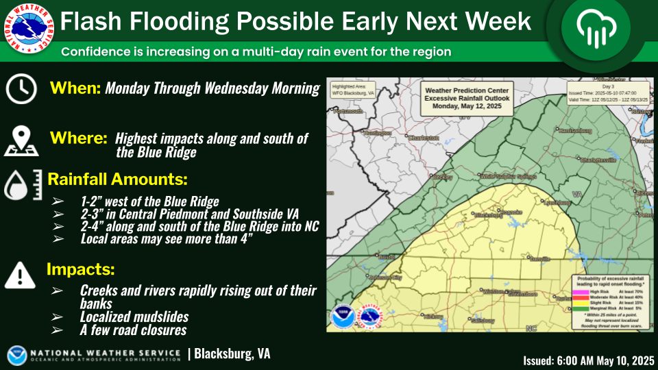
There is a Slight Risk for Excessive Rainfall that may result in
areas of flash flooding on Monday and Tuesday. Periods of prolonged
heavy rain may cause creeks and streams to rapidly rise out of their
banks and threaten nearby roads and bridges. The highest threat for
flash flooding will be along the crest of the Blue Ridge.
.SPOTTER INFORMATION STATEMENT…
Spotter activation is not expected at this time.