Last Updated on September 27, 2024 5:07 am
Flood Watch
National Weather Service Blacksburg VA
236 AM EDT Fri Sep 27 2024
NCZ001>006-018>020-VAZ007-009>020-022>024-032>035-043>047-058-059-
WVZ042>044-507-508-271900-
/O.CON.KRNK.FA.A.0013.000000T0000Z-240928T0000Z/
/00000.0.ER.000000T0000Z.000000T0000Z.000000T0000Z.OO/
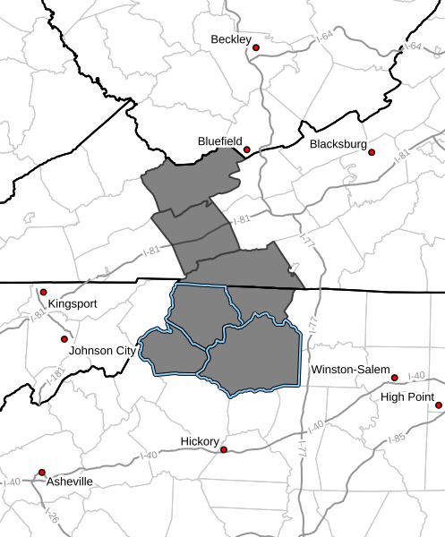
Ashe-Alleghany NC-Surry-Stokes-Rockingham-Caswell-Watauga-Wilkes-
Yadkin-Tazewell-Smyth-Bland-Giles-Wythe-Pulaski-Montgomery-
Grayson-Carroll-Floyd-Craig-Alleghany VA-Bath-Roanoke-Botetourt-
Rockbridge-Patrick-Franklin-Bedford-Amherst-Henry-Pittsylvania-
Campbell-Appomattox-Buckingham-Halifax-Charlotte-Mercer-Summers-
Monroe-Eastern Greenbrier-Western Greenbrier-
Including the cities of Danville, Keysville, South Boston,
Yadkinville, Appomattox, Galax, Amherst, Lynchburg, Marion,
Tazewell, Bland, Volney, Union, Radford, Flat Top, Dobson,
Wytheville, Blacksburg, New Castle, Floyd, Danbury, Salem, White
Sulphur Springs, Sparta, Independence, Hinton, Covington,
Troutdale, Roanoke, Buena Vista, Lewisburg, Bedford, Duo, West
Jefferson, Pearisburg, Clifton Forge, Hot Springs, Pulaski,
Yanceyville, Whitetop, Quinwood, Alderson, Fincastle, Boone,
Rocky Mount, Hix, Martinsville, Rainelle, Stuart, Lexington,
Eden, Wilkesboro, and Bluefield
236 AM EDT Fri Sep 27 2024
…FLOOD WATCH REMAINS IN EFFECT THROUGH THIS EVENING…
- WHAT…Flooding caused by excessive rainfall continues to be
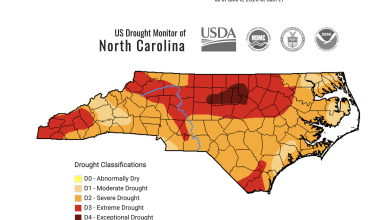
possible. - WHERE…Portions of North Carolina, including the following areas,
Alleghany NC, Ashe, Caswell, Rockingham, Stokes, Surry, Watauga,
Wilkes and Yadkin, Virginia, including the following areas,
Alleghany VA, Amherst, Appomattox, Bath, Bedford, Bland,
Botetourt, Buckingham, Campbell, Carroll, Charlotte, Craig, Floyd,
Franklin, Giles, Grayson, Halifax, Henry, Montgomery, Patrick,
Pittsylvania, Pulaski, Roanoke, Rockbridge, Smyth, Tazewell and
Wythe, and southeast West Virginia, including the following areas,
Eastern Greenbrier, Mercer, Monroe, Summers and Western Greenbrier. - WHEN…Through this evening.
- IMPACTS…Extensive street flooding and flooding of creeks and
rivers are possible. Area creeks and streams are running high and
could flood with more heavy rain. - ADDITIONAL DETAILS…
- An additional 4 to 6 inches, and locally higher amounts, of
rain will fall on already saturated soils. - http://www.weather.gov/safety/flood
PRECAUTIONARY/PREPAREDNESS ACTIONS…
You should monitor later forecasts and be alert for possible Flood
Warnings. Those living in areas prone to flooding should be prepared
to take action should flooding develop.