Last Updated on August 8, 2024 5:18 pm
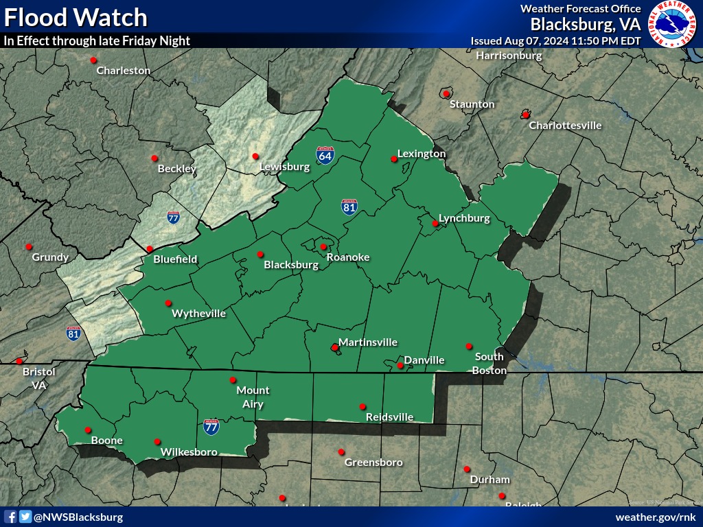
Flood Watch
National Weather Service Blacksburg VA
1154 AM EDT Thu Aug 8 2024
NCZ001-002-018-019-VAZ010>020-022>024-034-035-045>047-059-WVZ042>044-
507-508-090000-
/O.CON.KRNK.FA.A.0010.000000T0000Z-240810T0400Z/
/00000.0.ER.000000T0000Z.000000T0000Z.000000T0000Z.OO/
Ashe-Alleghany NC-Watauga-Wilkes-Bland-Giles-Wythe-Pulaski-
Montgomery-Grayson-Carroll-Floyd-Craig-Alleghany VA-Bath-Roanoke-
Botetourt-Rockbridge-Bedford-Amherst-Campbell-Appomattox-
Buckingham-Charlotte-Mercer-Summers-Monroe-Eastern Greenbrier-
Western Greenbrier-
Including the cities of Blacksburg, Roanoke, Wilkesboro, Clifton
Forge, Volney, Wytheville, Bland, New Castle, Rainelle, Hinton,
Independence, Hix, Radford, Salem, Boone, Amherst, Appomattox,
White Sulphur Springs, Covington, Hot Springs, West Jefferson,
Troutdale, Alderson, Lexington, Whitetop, Buena Vista, Bedford,
Union, Duo, Lynchburg, Quinwood, Galax, Fincastle, Pulaski,
Pearisburg, Flat Top, Lewisburg, Bluefield, Floyd, Keysville, and
Sparta
1154 AM EDT Thu Aug 8 2024
…FLOOD WATCH REMAINS IN EFFECT THROUGH FRIDAY EVENING…
- WHAT…Flooding caused by excessive rainfall continues to be
possible. - WHERE…Portions of northwest North Carolina, including the
following areas, Alleghany NC, Ashe, Watauga and Wilkes, Virginia,
including the following areas, Alleghany VA, Amherst, Appomattox,
Bath, Bedford, Bland, Botetourt, Buckingham, Campbell, Carroll,
Charlotte, Craig, Floyd, Giles, Grayson, Montgomery, Pulaski,
Roanoke, Rockbridge and Wythe, and southeast West Virginia,
including the following areas, Eastern Greenbrier, Mercer, Monroe,
Summers and Western Greenbrier. - WHEN…Through Friday evening.
- IMPACTS…Extensive street flooding and flooding of creeks and
rivers are possible. - ADDITIONAL DETAILS…
- As Tropical Storm Debby moves across the region, a prolonged
period of rain, heavy at times, can be expected today through
Friday. Rainfall amounts between 3 and 7 inches are possible
across the area by Friday night, with locally higher amounts
possible. - Http://www.weather.gov/safety/flood
PRECAUTIONARY/PREPAREDNESS ACTIONS…
You should monitor later forecasts and be alert for possible Flood
Warnings. Those living in areas prone to flooding should be prepared
to take action should flooding develop.