Last Updated on June 11, 2021 7:10 am
NCZ001>004-018>020-VAZ010>020-022>024-032>035-043>047-058-059-
WVZ042>044-507-508-111615-
/O.CON.KRNK.FF.A.0003.210611T1600Z-210612T0400Z/
/00000.0.ER.000000T0000Z.000000T0000Z.000000T0000Z.OO/
Ashe-Alleghany NC-Surry-Stokes-Watauga-Wilkes-Yadkin-Bland-Giles-
Wythe-Pulaski-Montgomery-Grayson-Carroll-Floyd-Craig-Alleghany VA-
Bath-Roanoke-Botetourt-Rockbridge-Patrick-Franklin-Bedford-Amherst-
Henry-Pittsylvania-Campbell-Appomattox-Buckingham-Halifax-Charlotte-
Mercer-Summers-Monroe-Eastern Greenbrier-Western Greenbrier-
Including the cities of Roanoke, Wilkesboro, Sparta, Union, Pulaski,
Covington, Danville, Appomattox, Hinton, Independence, Fincastle,
Buena Vista, Danbury, Hix, Duo, Floyd, Bluefield, Hot Springs,
Clifton Forge, Rainelle, Lynchburg, Wytheville, Yadkinville,
Whitetop, Bedford, Volney, Martinsville, Pearisburg, Blacksburg,
West Jefferson, Lexington, Quinwood, Radford, Boone, Stuart,
Lewisburg, Alderson, New Castle, Dobson, Rocky Mount, South Boston,
Galax, Keysville, Salem, Flat Top, Amherst, Bland, White Sulphur
Springs, and Troutdale
405 AM EDT Fri Jun 11 2021
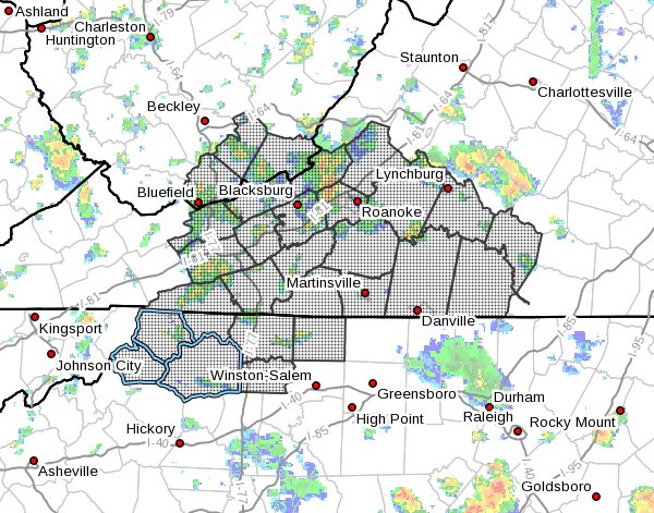
...FLASH FLOOD WATCH REMAINS IN EFFECT FROM NOON EDT TODAY THROUGH
THIS EVENING...
The Flash Flood Watch continues for
* Portions of North Carolina...Virginia and southeast West Virginia,
  including the following areas, in North Carolina, Alleghany NC,
  Ashe, Stokes, Surry, Watauga, Wilkes and Yadkin. In Virginia,
  Alleghany VA, Amherst, Appomattox, Bath, Bedford, Bland,
  Botetourt, Buckingham, Campbell, Carroll, Charlotte, Craig, Floyd,
  Franklin, Giles, Grayson, Halifax, Henry, Montgomery, Patrick,
  Pittsylvania, Pulaski, Roanoke, Rockbridge and Wythe. In southeast
  West Virginia, Eastern Greenbrier, Mercer, Monroe, Summers and
  Western Greenbrier.
* From Noon EDT today through this evening
* A cold front will drift southward into central and southern
  Virginia this evening. Fueled by deep moisture ahead of the front,
  scattered showers and thunderstorms will develop this afternoon
  and evening across the region. The stronger thunderstorms will be
  capable of producing locally heavy rainfall at rates of 2 to 3
  inches per hour. Flash flooding may occur where storms move very
  slowly or pass repeatedly over the same locations.