Last Updated on March 26, 2022 2:45 pm
WataugaOnline.com updates on the possible impacts from Hurricane Florence to western North Carolina.
Link – Flash Flood Watch Issued Saturday Morning Through Monday Evening – September 14-September 18, 2018
Updated Link – Wind Advisory extended until midnight tonight- Sunday Sept 16 for Ashe-Alleghany NC-Surry-Watauga-Wilkes-Smyth-Grayson-Carroll- Patrick
SHELTER INFORMATION FOR WATAUGA COUNTY: Alliance Bible Fellowship will be opened as a shelter for Watauga County starting Saturday, Sept 15, at 5:00pm.
The Quinn Center on the ASU campus, located on Stadium Drive across from the football stadium, has been designated as a shelter and will open at 5pm Saturday, Sept 15, for students, faculty, and staff who may be displaced by severe weather.
Appalachian State University classes are canceled Monday, Sept. 17, and Tuesday, Sept. 18. For non-faculty employees, the Adverse Weather Policy is in effect at Condition 1 (Reduced Operations) Monday, Sept. 17, and Tuesday, Sept. 18. Further decisions about employee status will be made by 5 p.m. Sunday. Weather conditions may vary across the county. Please use caution during inclement weather, and monitor http://appstatealert.com for any updates.
Link – Entire Blue Ridge Parkway To Close Ahead of Hurricane Florence
Link – NC DEQ Watauga Hazards Maps showing Landslide Hazards
Link – North Carolina Flood Inundation Mapping and Alert Network
Use the slider bar in the Twitter feed to view more tweets.
Tweets by @WataugaOnline
Monday September 17 Updates:
PUBLIC INFORMATION STATEMENT
NATIONAL WEATHER SERVICE BLACKSBURG VA
930 AM EDT MON SEP 17 2018
…RAINFALL REPORTS FOR THE PAST 48 HOURS FROM REMNANTS OF FLORENCE…
LOCATION AMOUNT TIME/DATE
…NORTH CAROLINA…
…ALLEGHANY COUNTY…
1 WSW BARRETT 9.97 IN 0815 AM
3 NE SPARTA 6.58 IN 0700 AM
2 S WHITEHEAD 6.54 IN 0842 AM
1 WSW WHITEHEAD 5.24 IN 0840 AM
BARRETT 3.72 IN 0855 AM
…ASHE COUNTY…
3 SE SPARTA 10.20 IN 0745 AM
2 NE DEEP GAP 7.79 IN 0700 AM
1 SE BALDWIN 7.00 IN 0830 AM
1 SSW BALDWIN 4.74 IN 0700 AM
JEFFERSON 2 E 4.45 IN 0620 AM
JEFFERSON 3.97 IN 0750 AM
LANSING RG DCP 3.76 IN 0815 AM
WEST JEFFERSON 3.67 IN 0855 AM
CLIFTON 3.52 IN 0845 AM
1 W NELLA 3.30 IN 0700 AM
3 W SCOTTVILLE 3.09 IN 0854 AM
1 SW BALDWIN 2.08 IN 0800 AM
1 SSE JEFFERSON 0.80 IN 0845 AM
…WATAUGA COUNTY…
1 SW AHO 7.29 IN 0724 AM
AHO 7.05 IN 0700 AM
BOONE PRECIP (TVA) 2S 6.07 IN 0815 AM
BOONE 5.98 IN 0700 AM
1 NNE AHO 5.97 IN 0800 AM
1 SE RUTHERWOOD 5.83 IN 0730 AM
1 WNW BLOWING ROCK 5.80 IN 0840 AM
1 E SEVEN DEVILS 5.56 IN 0650 AM
1 NNW BOONE 5.14 IN 0700 AM
1 E SILVERSTONE 5.11 IN 0829 AM
BOONE 5.05 IN 0845 AM
1 ESE BOONE 5.01 IN 0850 AM
SEVEN DEVILS 4.98 IN 0800 AM
3 SSE FOSCOE 4.75 IN 0852 AM
FOSCOE 4.64 IN 0800 AM
2 W BLOWING ROCK 4.61 IN 0853 AM
1 ESE BOONE 4.28 IN 0755 AM
1 ENE FOSCOE 3.94 IN 0800 AM
BOONE 3.79 IN 0800 AM
1 WNW AHO 3.36 IN 0845 AM
VALLE CRUCIS 2.99 IN 0700 AM
1 SE BEECH MOUNTAIN 2.36 IN 0700 AM
WATAUGA RIVER 1.86 IN 0830 AM
2 SSW REESE 1.85 IN 0700 AM
1 NNW BEECH MOUNTAIN 1.81 IN 0855 AM
…WILKES COUNTY…
NORTH WILKESBORO 5.00 IN 0900 AM
3 ESE MORAVIAN FALLS 4.58 IN 0854 AM
4 WNW WINDY GAP 4.51 IN 0823 AM
2 SSE WILBAR 4.28 IN 0810 AM
2 E DOCKERY 3.71 IN 0853 AM
2 SSE BUCK 3.61 IN 0845 AM
ELKVILLE 3.45 IN 0845 AM
PURLEAR 4.6 WNW 2.98 IN 1000 PM
Here's a list of flooded roads and bridges in the county from NCDOT at 9:48am:
Hubert Thomas Rd
Dewitt Barnett Rd bridge
Watauga River Rd near Long Ridge Road,
Guy Ford Rd
Brookshire Rd
Dell Coffey Rd near Roby Greene Rd
New River Hills
Officials with App State say that as of 9am Monday, campus has experienced no significant flooding issues. Also one tree fell on campus behind Mountaineer Hall – and was cleared overnight on Sunday. About 50 percent of students who live in on-campus housing, just under 3,000, remained on campus through the weekend. Residence halls and dining facilities remain open for them, as well as campus facilities that could provide activities and entertainment.
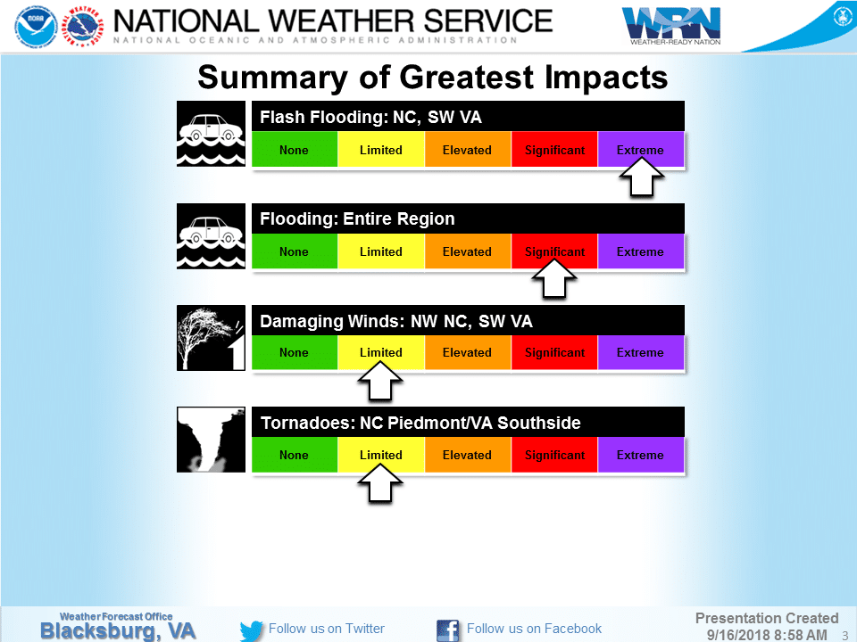
National Weather Service Monday morning update
Link – Most NCDMV Offices to be Closed Monday Due to Hurricane Florence
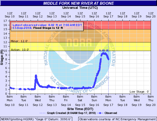
Flood Warning remains in effect until 10:30am
Middle Fork New River gauge at 8:17am
Watauga River gauge just before 8am

Sunday September 16 Updates:
Flash Flood Warning until 1:30am.
Watauga County, Ashe County and Avery County schools are closed for Monday – School Closings/Cancellations
2:32pm – App State says that about 50% of students who live in on-campus housing, just under 3,000, remained on campus through the weekend. Residence halls and dining facilities remain open for them, as well as campus facilities that could provide activities and entertainment.
Governor Cooper's 12noon update
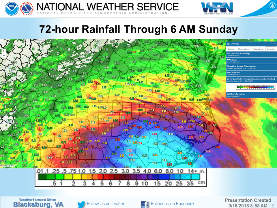
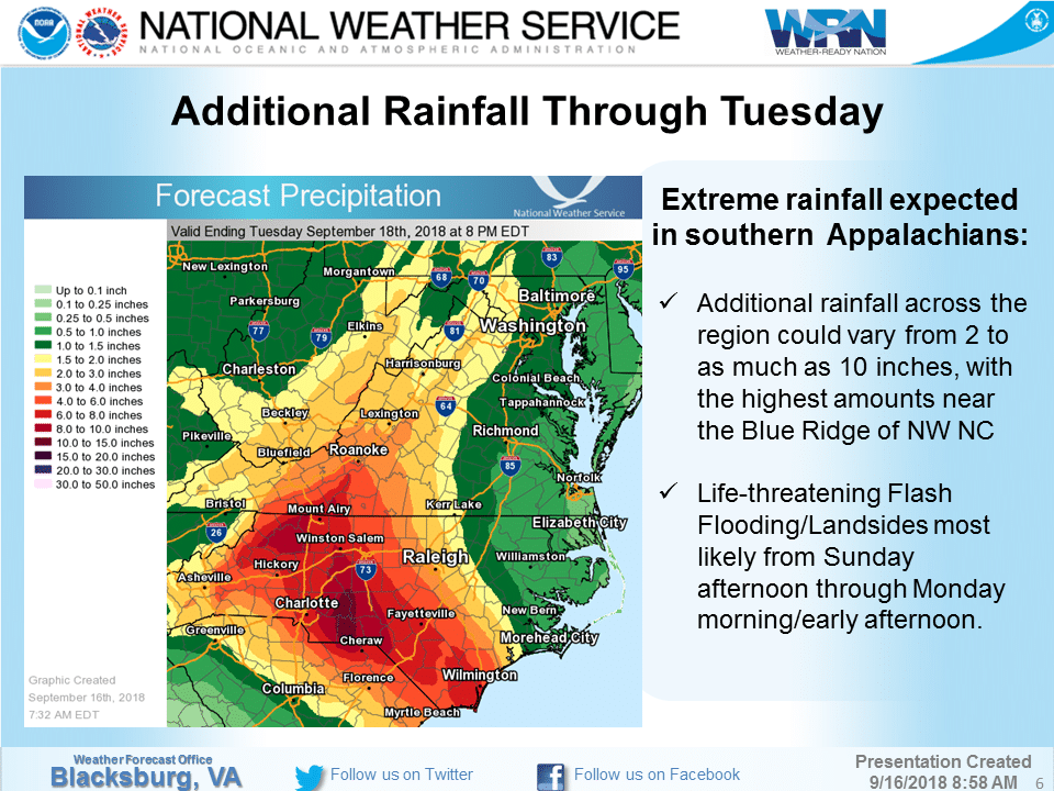
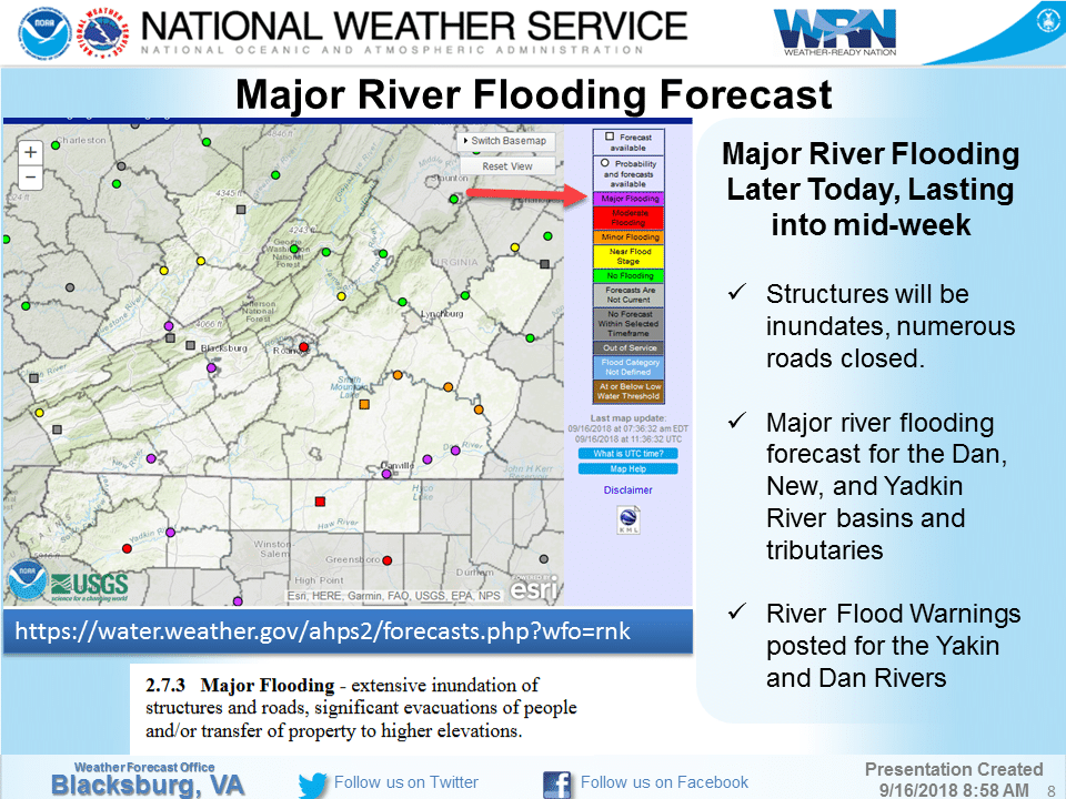
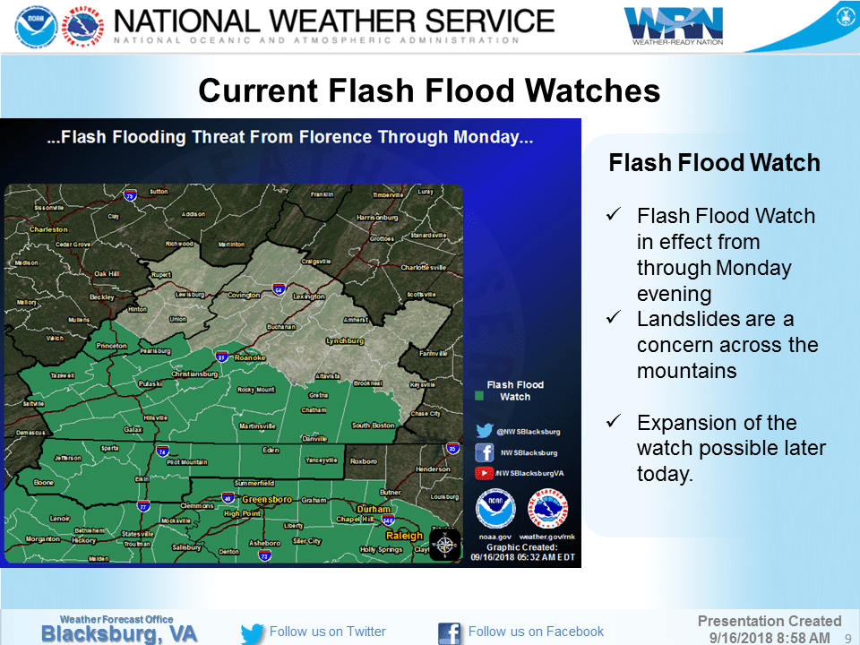
National Weather Service update


North Carolina Emergency Management Sunday morning update
Saturday September 15 Updates:
Link – Appalachian State Emergency Management Saturday Update On Florence
North Carolina Emergency Management Saturday night update
Residents at Bavarian village apartments are barricading their front and back doors @SpecNewsCLT pic.twitter.com/VcnYFnsBvd
— Rose Eiklor (@Rose_Eiklor) September 15, 2018
5:48pm -Boone Police and Boone Fire knocking on doors asking people in flood zones to evacuate.
Boone businesses are prepped for flooding. @SpecNewsCLT pic.twitter.com/1Mxo26wJwa
— Rose Eiklor (@Rose_Eiklor) September 15, 2018
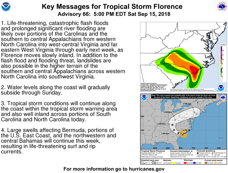
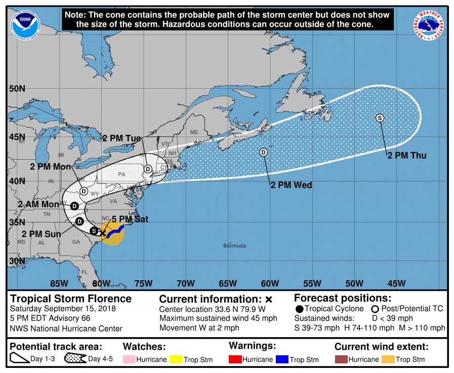
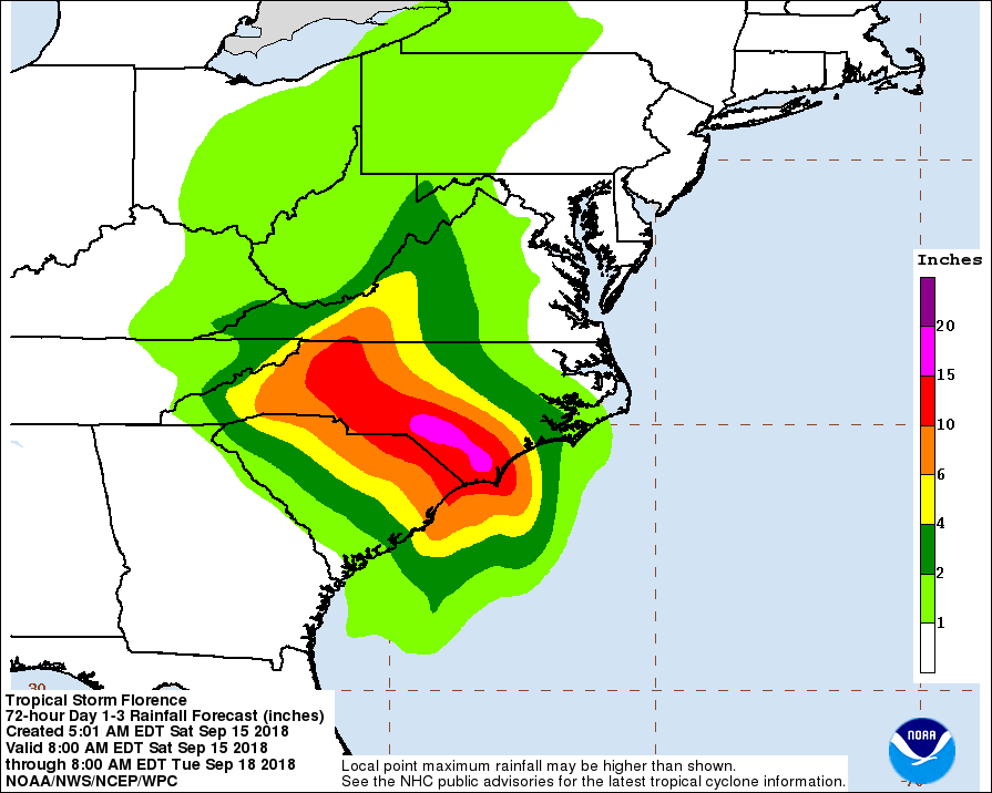
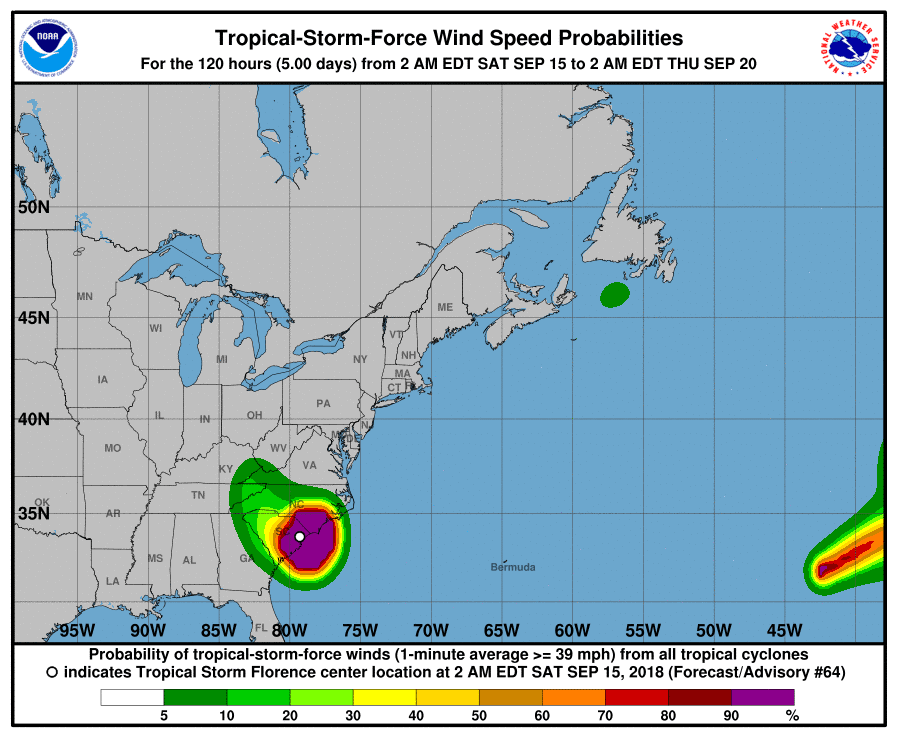
National Hurricane Center 5pm update
Gov. Roy Cooper 3:30pm update
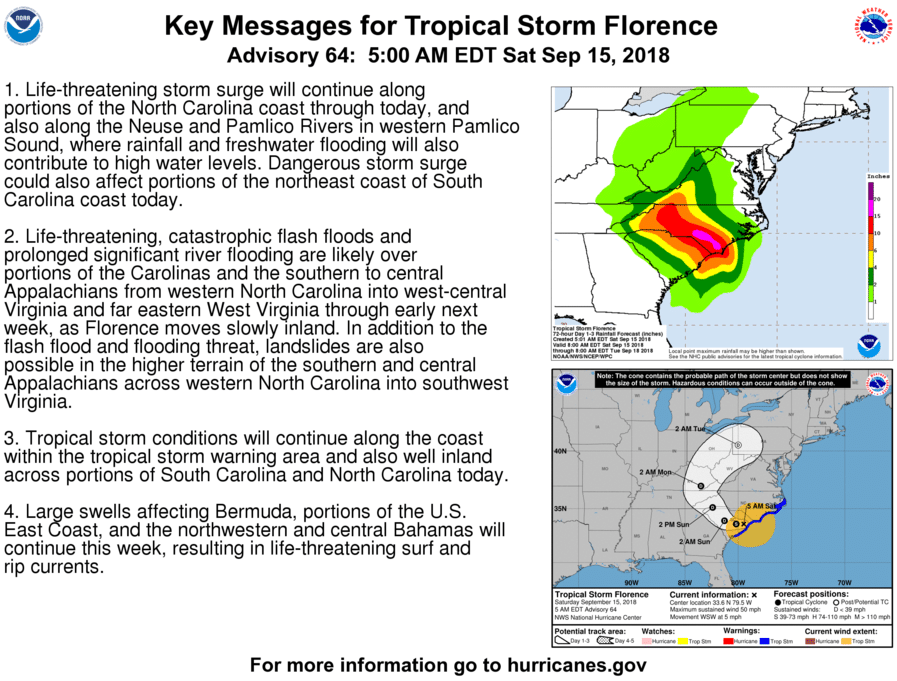
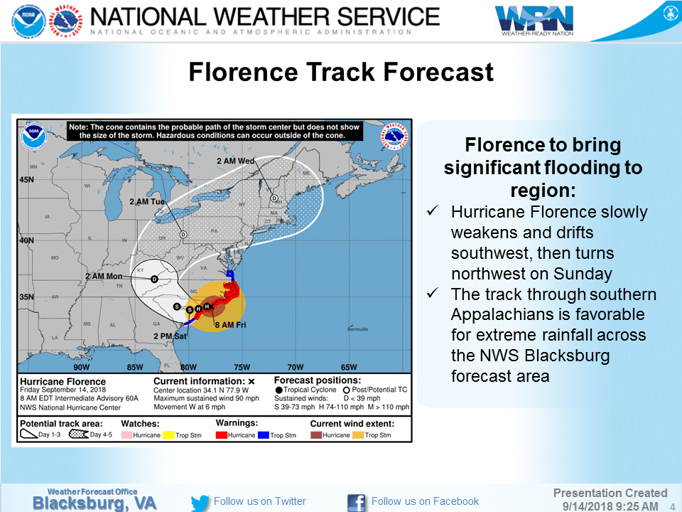
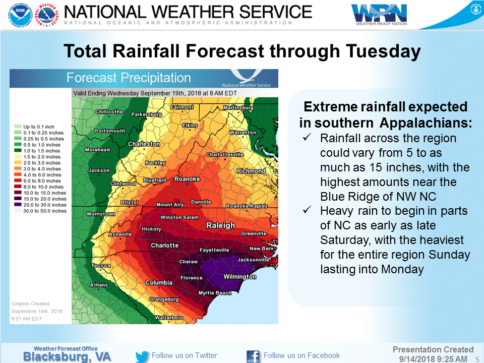
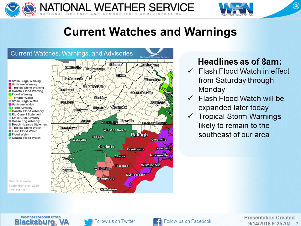
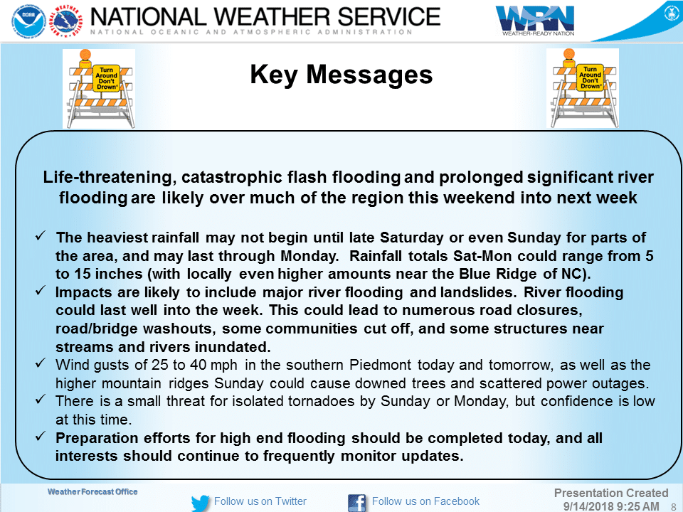
National Weather Service Saturday morning update
Gov. Roy Cooper 11am update
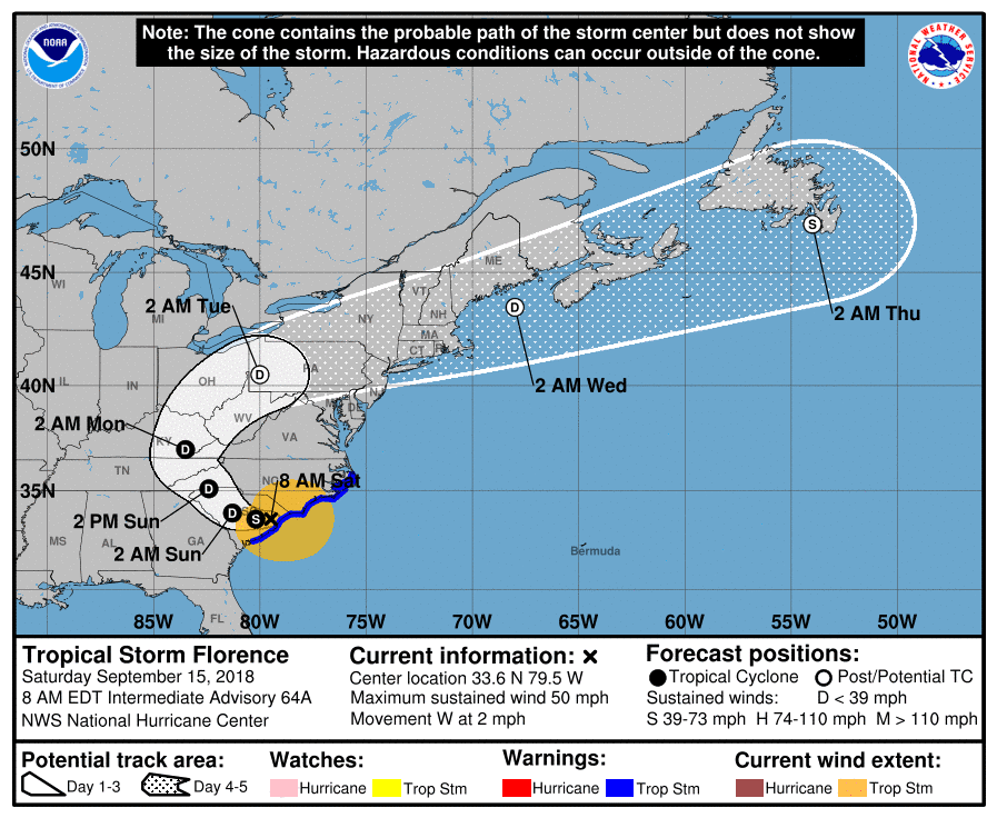
8am National Hurricane Center update
From ASU Police: All vehicles parked in flood-prone areas on the AppState campus, such as Peacock, Duncan, State Farm, and Levine Hall parking lots, should be moved to other lots on higher ground to prevent flood damage. All of these lots will be closed.
The Quinn Center on the ASU campus, located on Stadium Drive across from the football stadium, has been designated as a shelter and will open at 5pm Saturday, 9/15, for students, faculty, and staff who may be displaced by severe weather.
Appalachian State University classes are canceled Monday, Sept. 17, and Tuesday, Sept. 18. For non-faculty employees, the Adverse Weather Policy is in effect at Condition 1 (Reduced Operations) Monday, Sept. 17, and Tuesday, Sept. 18. Further decisions about employee status will be made by 5 p.m. Sunday. Weather conditions may vary across the county. Please use caution during inclement weather, and monitor http://appstatealert.com for any updates.
Link – Wind Advisory from Saturday 9/15/2018 4:00 PM to Sunday 9/16/2018 4:00 PM EDT for Watauga County, Ashe County
5am National Hurricane Center update

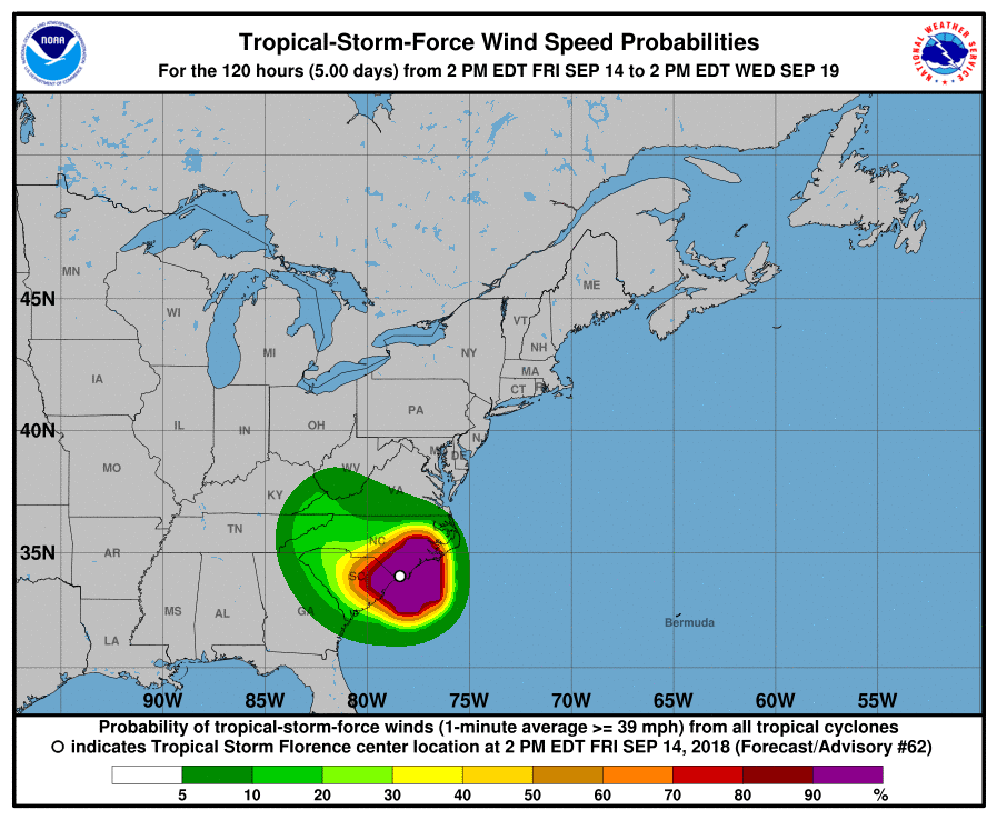
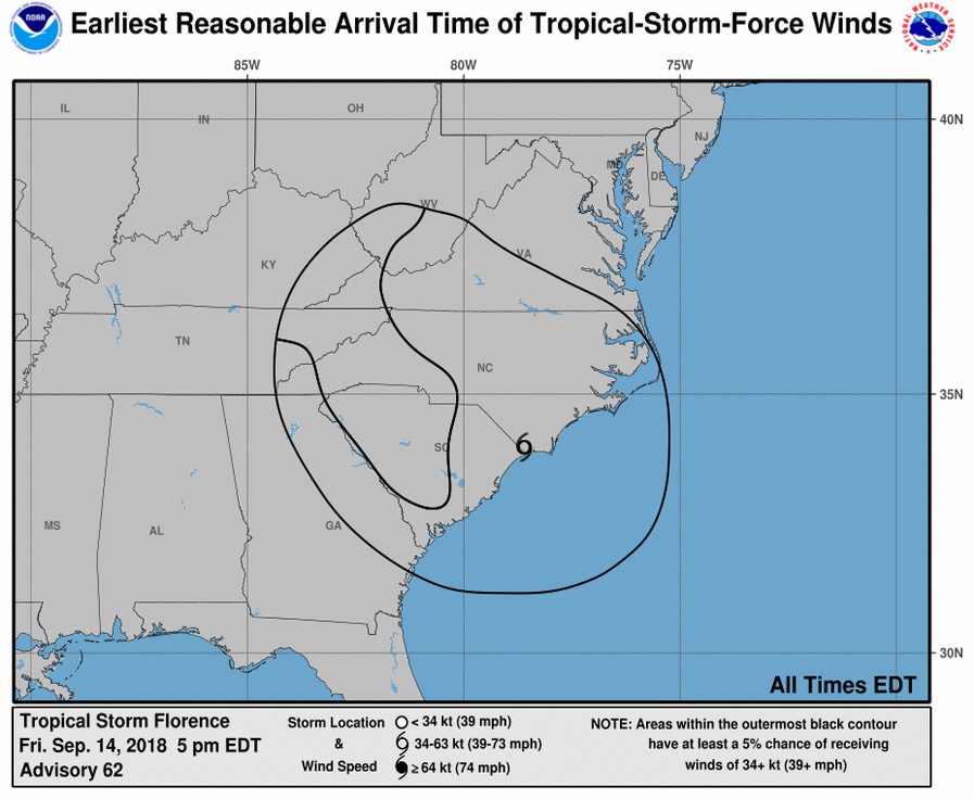
Friday September 14 Updates:
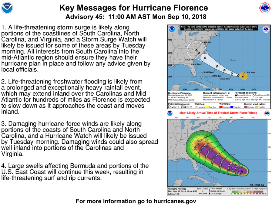
5pm Gov. Roy Cooper update
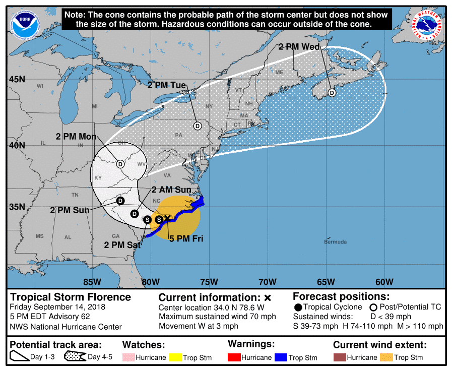
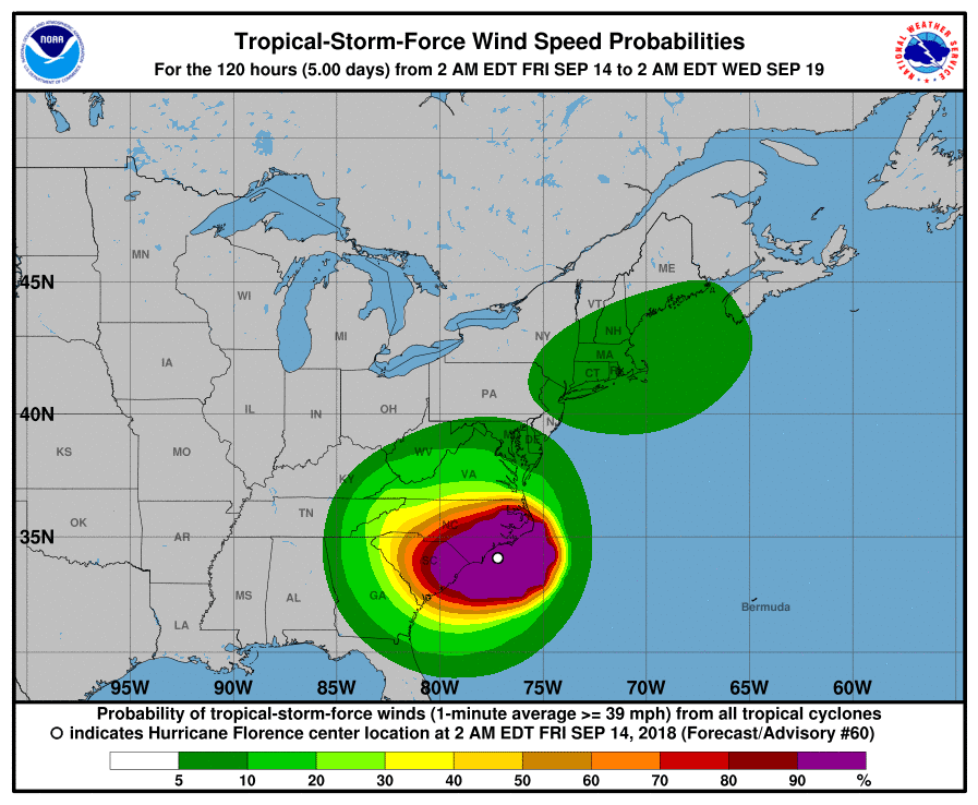
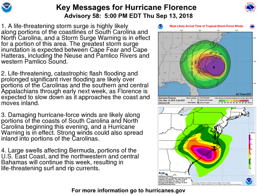
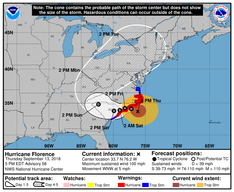
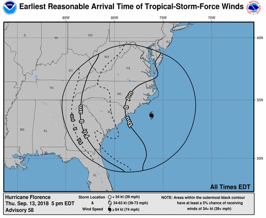
5pm National Hurricane Center update

SHELTER INFORMATION FOR WATAUGA COUNTY: Alliance Bible Fellowship will be opened as a shelter for Watauga County starting tomorrow Saturday 9/15 at 5:00pm, per Emergency Management
Link – Entire Blue Ridge Parkway To Close Ahead of Hurricane Florence
Gov. Roy Cooper 11am update
National Weather Service update
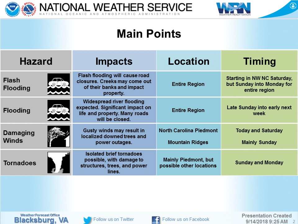
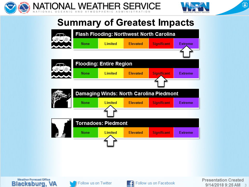

Link – Flash Flood Watch Issued Saturday Morning Through Monday Evening – September 14-September 18, 2018

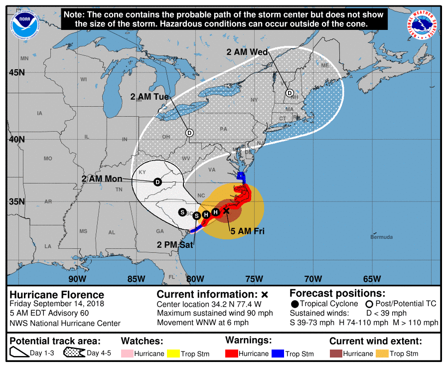
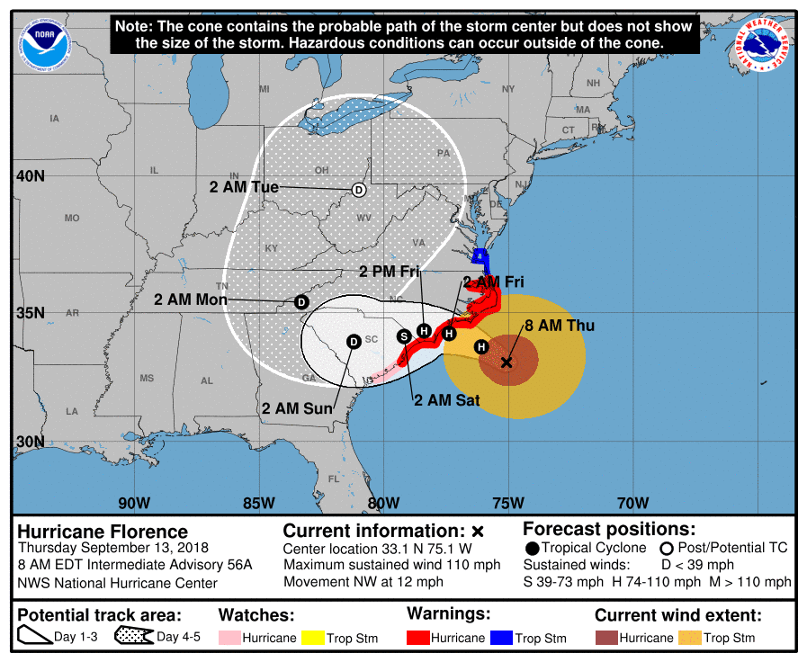
From NWS – Florence officially made landfall near Wrightsville Beach, NC at 7:15 AM EDT this morning with a wind gust of 105 mph recorded at Wilmington Airport. Impacts from Florence will continue in the Carolinas for the next 2 days as Florence will be very slow to leave the region.
North Carolina Emergency Management update
National Hurricane Center 5am update

Thursday September 13 Updates:
Link – App State Athletics Event Changes for This Weekend
5pm National Hurricane Center update

Governor Roy Cooper 5pm update.
Link – Blue Ridge Parkway Anticipates Impacts from Hurricane Florence
Link – Flash Flood Watch from Saturday 9/15/2018 8:00 AM to Tuesday 9/18/2018 8:00 AM EDT for Avery County.
National Weather Service update
Governor Roy Cooper 10am update
Link – National Forests In North Carolina To Temporarily Close Some Roads Ahead Of Hurricane Florence
Link – North Carolina Price Gouging Law In Effect
North Carolina Emergency Management update
Link – NCDOT Helping with Evacuations, Division 11 Crews Preparing For Hurricane
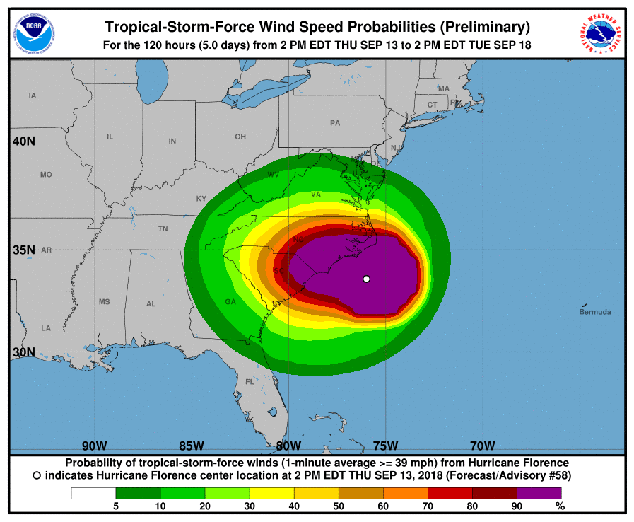
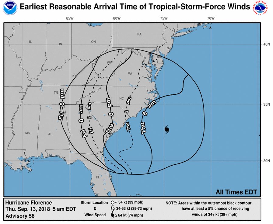
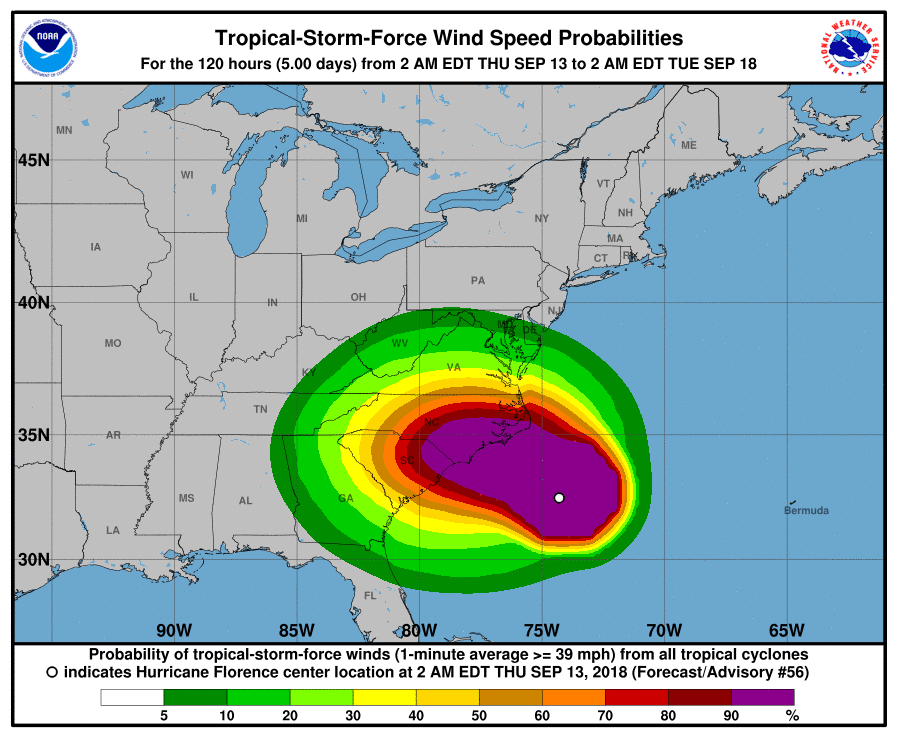
National Hurricane Center 8am update
Wednesday September 12 Updates:
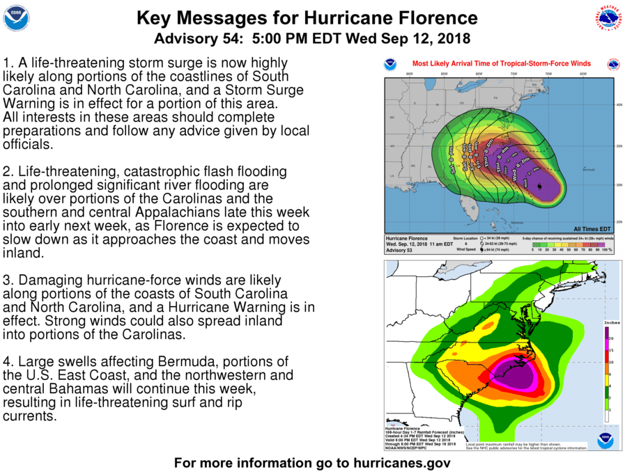
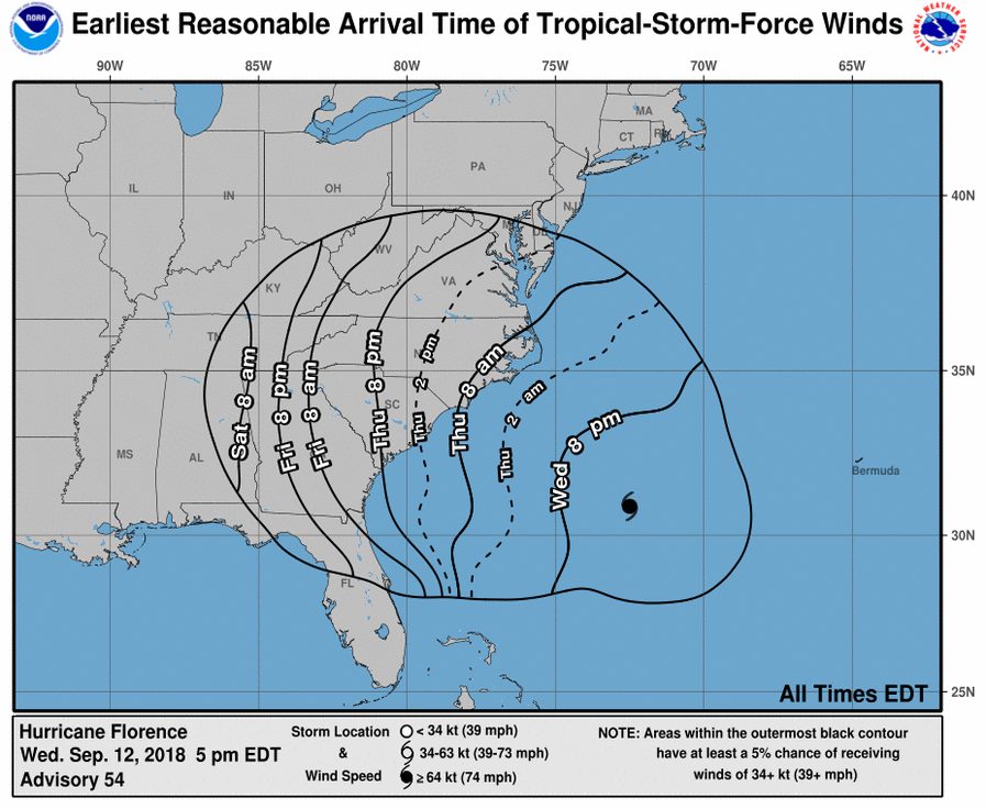
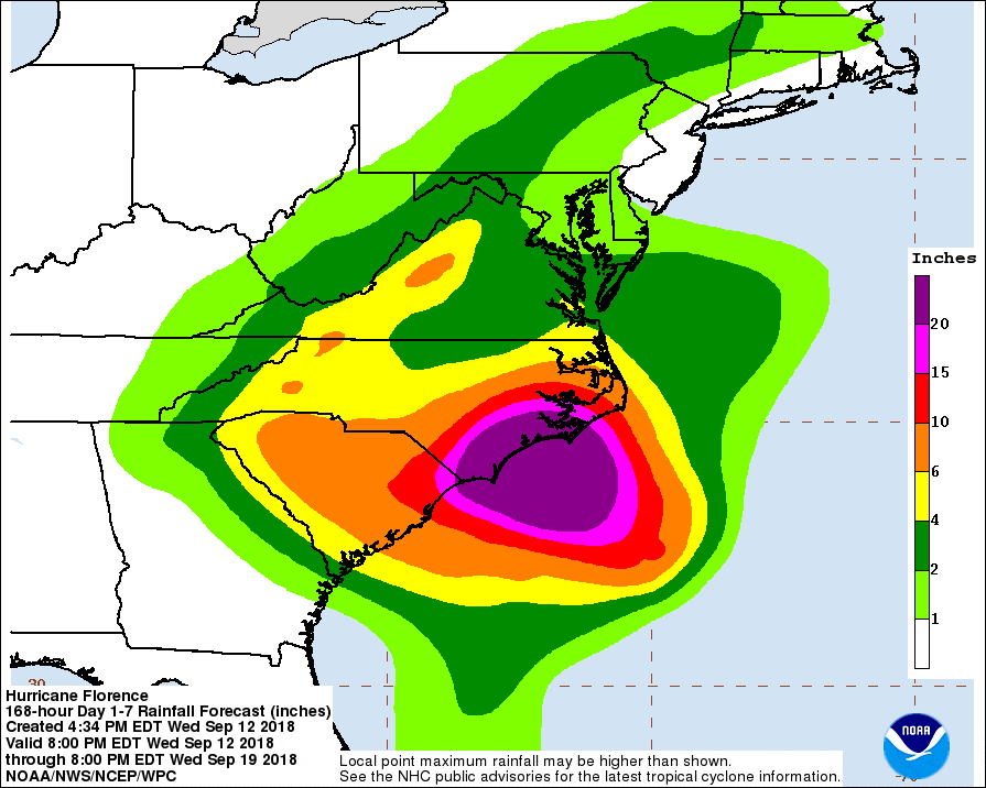
National Hurricane Center 5pm Update
Governor Roy Cooper 5pm update
Watauga County Schools Prepares For Impacts From Hurricane Florence
National Forests In North Carolina To Close Campgrounds And Offices Ahead of Hurricane Florence
The Jimmy Smith Maranon and Street Party original schedule for Friday by the Town of Boone has been rescheduled for Friday, October 19, 2018.
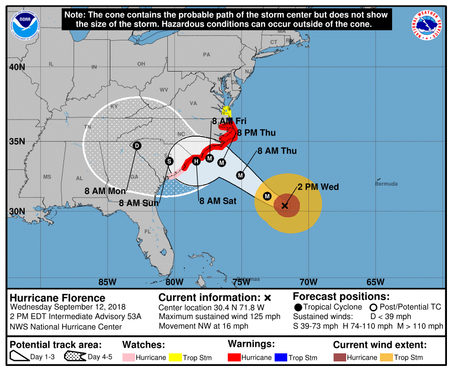
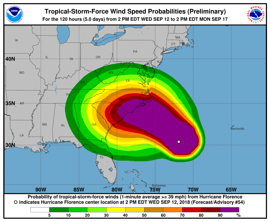
2pm National Hurricane Center udpate

App State-Southern Miss Football Game Will Not Be Played Saturday
National Weather Service Tuesday morning update


Governor Roy Cooper 10am update
UPDATE – ALL Campgrounds in VA & NC are under a mandatory evacuation order until further notice. Affected campers are eligible for refunds. Backcountry camping areas are also included. #hurricaneflorence
— Blue Ridge Parkway (@BlueRidgeNPS) September 12, 2018
Brad Panovich Tuesday morning update.
North Carolina Emergency Management update
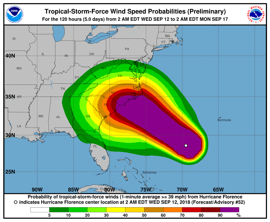
5am update from the National Hurricane Center


Tuesday September 11 Updates:
Update from the National Weather Service at 6pm regarding possible impacts to western North Carolina:
“Florence remains a dangerous Category 4 hurricane and may even strengthen somewhat over the next 24 hours or so. Florence is still forecast to approach the southeast coast of NC (possibly far northern coast of SC) now on Friday and may make landfall later in the day Friday. Trends since this morning have been to continue to slow or stall the system out near the coast or just inland and then where it goes from there is somewhat more uncertain, but with some trends in important models to eventually drift it west or even southwest into far western NC or western SC. Other modes take it even farther south, and some still slowly take it up into VA. But impacts to the Blacksburg county warning area may not be felt now until later in the weekend, although we still cannot rule out some tropical storm force winds reaching into a few of our Piedmont counties on Friday. As of now, we are not issuing any Tropical Storm Watches, but some have been issued for parts of eastern VA and inland NC west of where Hurricane Watches have been posted. We have fairly low confidence at the moment that these strength winds will reach into our area, but even winds of 25-35 mph with wet ground could cause some impacts from downed trees.
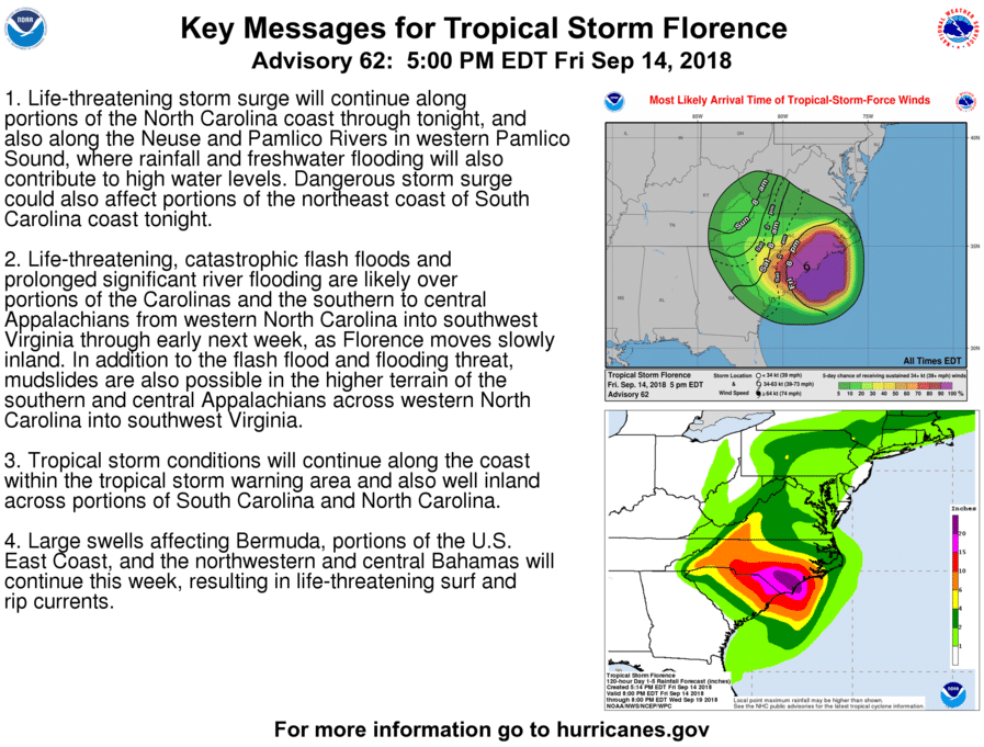
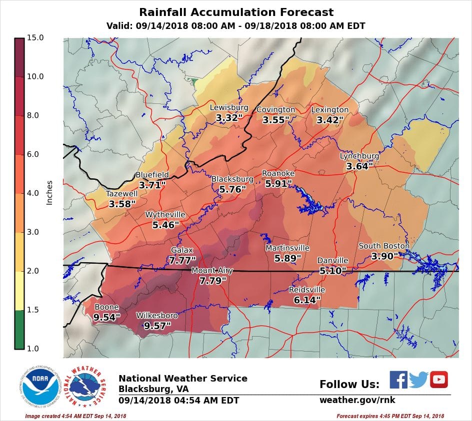
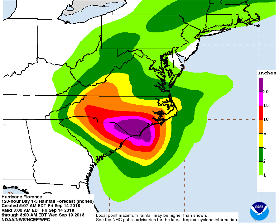
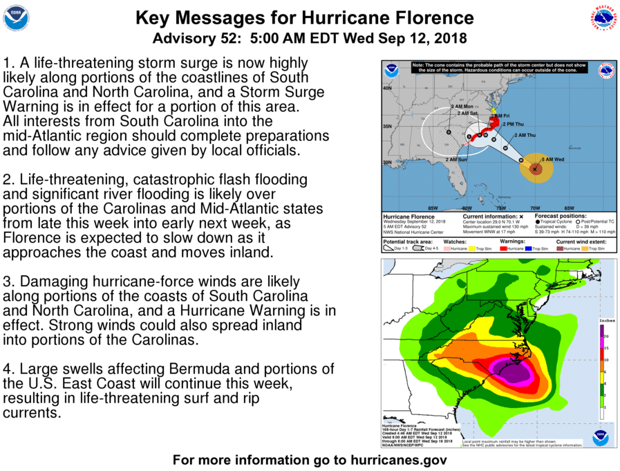
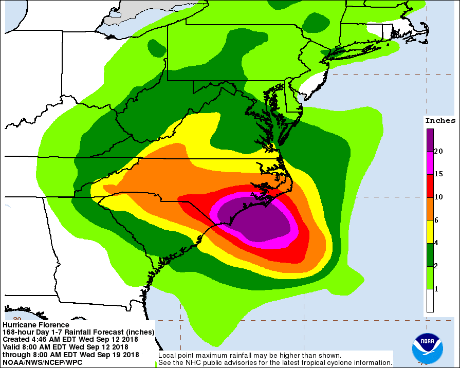
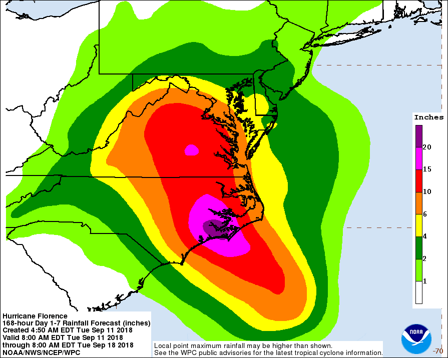
The much bigger concern remains the heavy rain and significant flooding potential, even though uncertainties still exist as far as timing of when this will start and where will see the greatest rainfall amounts. A slow track into western NC is a worse case scenarios and could result in 10-15 inches of rain in the mountains of NW NC and SW VA by early next week, which could have catastrophic consequences in terms of widespread flash flooding and major river flooding, as well as widespread landslide activity. The rainfall forecast image attached is a best guess for now but expect changes as we get closer to the end of the week, yet we are not confident in which direction these changes may go. If the models which slide Florence to the southwest over the weekend are correct, the NW NC mountains may get considerably less and Virginia may get very little. But the opposite could happen too.
The main message is continue to plan for the worse case scenario especially in terms of rainfall, and also that impacts may not really begin for most of our area until later in the weekend. We will hopefully be able to slowly refine this challenging but critical forecast over the next couple of days.”
App State Athletics monitoring weather conditions for Saturday's football game. More information at this link.
Appalachian State University classes are canceled from 5 p.m. Sept. 12 to 5 p.m. Sept. 16 to allow students who live in areas likely to be severely impacted by Hurricane Florence to prepare accordingly. For non-faculty employees, the Adverse Weather Policy is in effect at Condition 1 (Reduced Operations) from 5 p.m. Sept. 12 to 5 p.m. Sept. 16. Weather conditions may vary across the county.
Governor Roy Cooper 12:30pm update
National Weather Service Tuesday morning update.
North Carolina Emergency Management Tuesday morning update.
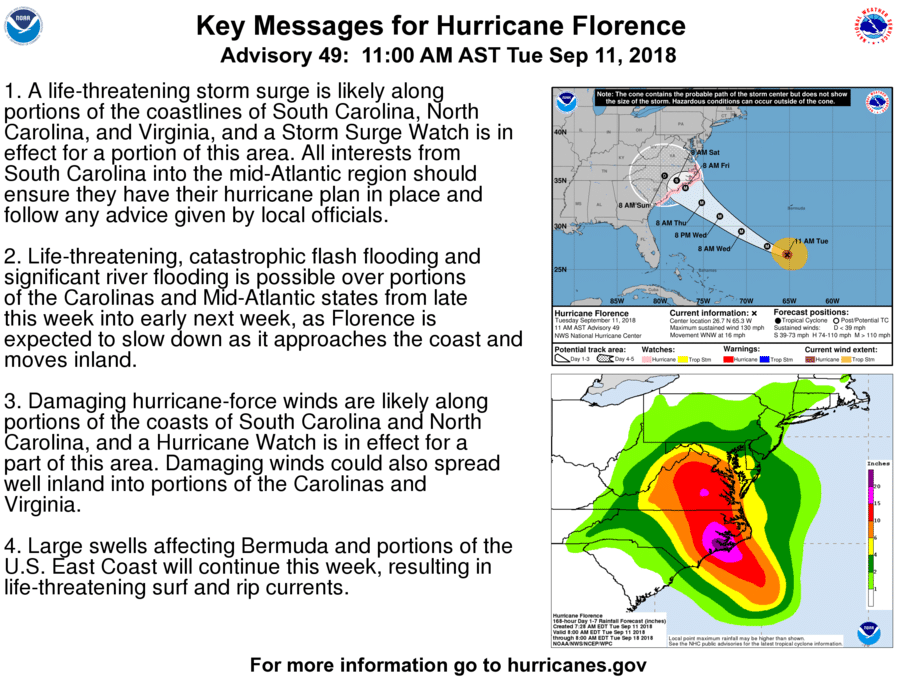
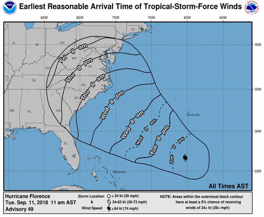
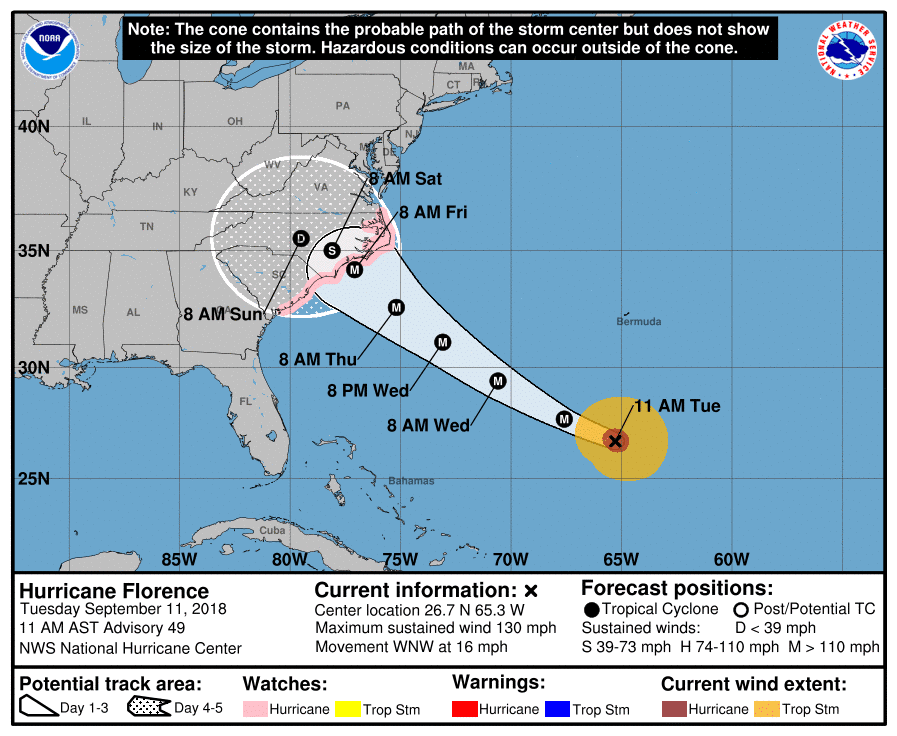
11am Tuesday Sept 11 National Hurricane Center updates

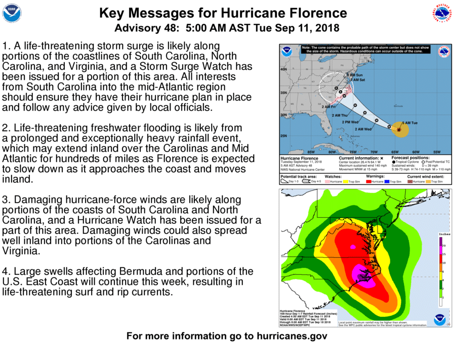
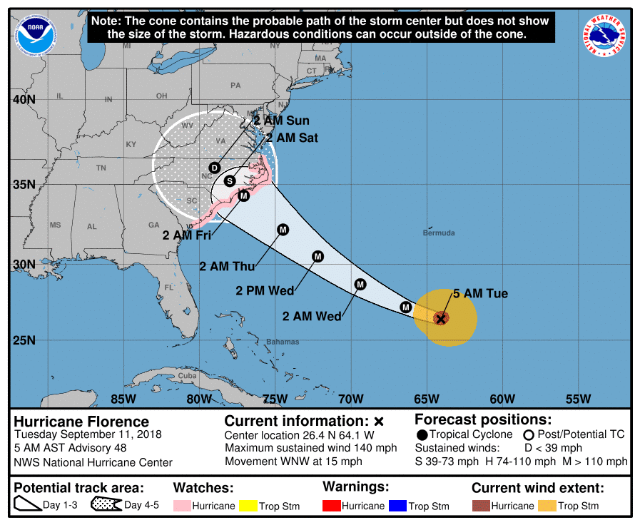
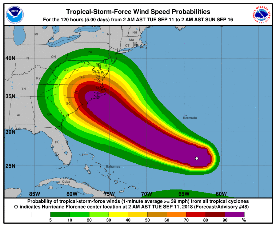
5am Tuesday Sept 11 National Hurricane Center updates
Monday September 10 Updates:
Governor Cooper Seeks Federal Disaster Declaration Ahead of Historic Hurricane Florence
Blue Ridge Energy Prepares for Potential Impacts of Hurricane Florence

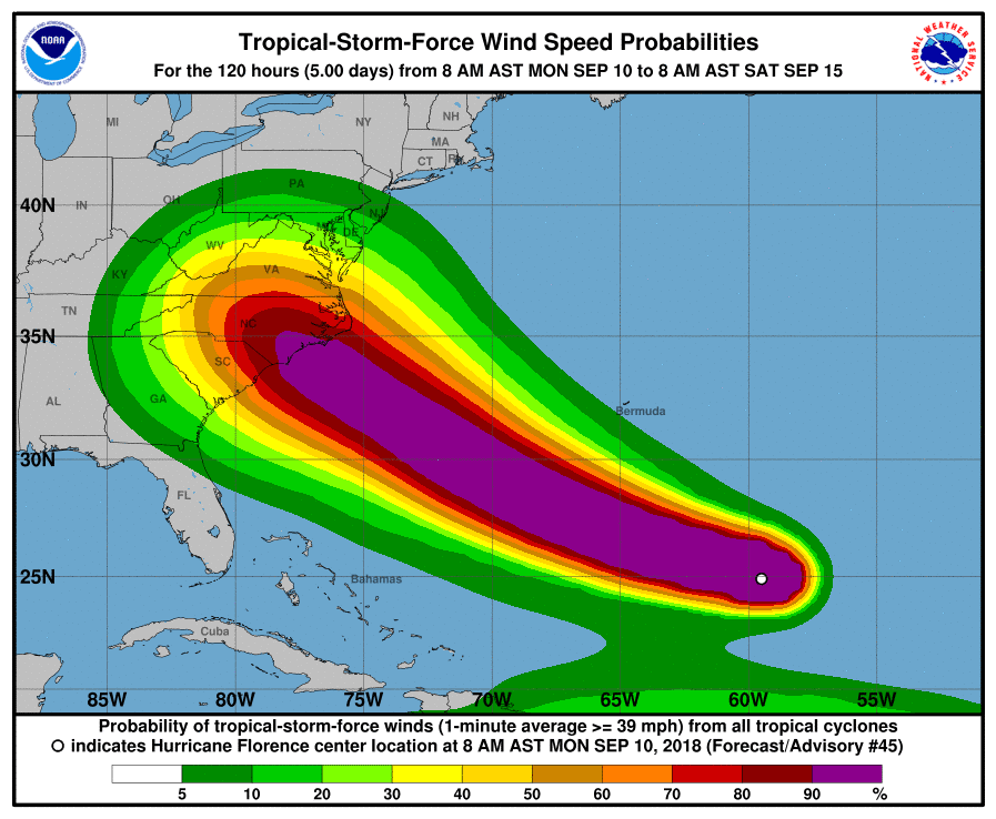
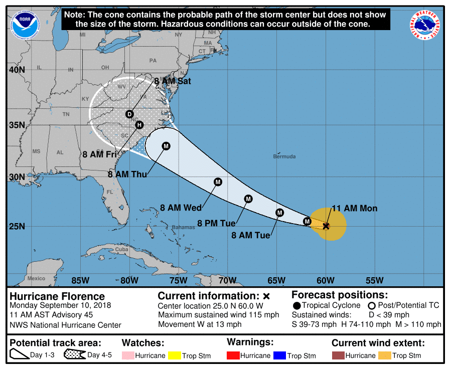
11am update Monday September 10, 2018 – National Hurricane Center updates
Sunday September 9, 2018 Updates:
N.C. Readies for Florence as Storm Strengthens Sunday
NC Governor Cooper: North Carolina Monitoring Florence Closely, Preparing for Any Impacts
Gov. Cooper Issues Emergency Orders in Advance of Storm to Help Farmers