Last Updated on January 2, 2020 12:33 pm
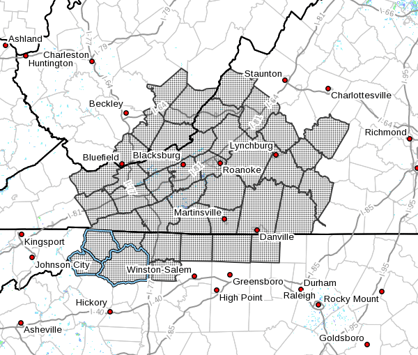
Ashe-Alleghany NC-Surry-Stokes-Watauga-Wilkes-Yadkin-Tazewell-
Smyth-Bland-Giles-Wythe-Pulaski-Montgomery-Grayson-Carroll-Floyd-
Craig-Alleghany VA-Bath-Roanoke-Botetourt-Rockbridge-Patrick-
Franklin-Bedford-Amherst-Henry-Mercer-Summers-Monroe-
Eastern Greenbrier-Western Greenbrier-
Including the cities of West Jefferson, Sparta, Dobson, Danbury,
Boone, Wilkesboro, Yadkinville, Tazewell, Marion, Bland,
Pearisburg, Wytheville, Radford, Pulaski, Blacksburg,
Independence, Whitetop, Troutdale, Volney, Galax, Floyd,
New Castle, Clifton Forge, Covington, Hot Springs, Roanoke,
Salem, Fincastle, Lexington, Buena Vista, Stuart, Rocky Mount,
Amherst, Martinsville, Bluefield, Hinton, Hix, Union, Lewisburg,
White Sulphur Springs, Quinwood, Duo, and Rainelle
335 PM EST Thu Dec 12 2019
…WINTER WEATHER ADVISORY NOW IN EFFECT FROM MIDNIGHT TONIGHT TO
3 PM EST FRIDAY…
WHAT…Freezing rain. Freezing rain will start with a brief mix
of sleet and snow. Total snow and sleet accumulations less than
one inch. Ice accumulations of up to two tenths of an inch.
Locally higher amounts are likely along the Blue Ridge.
WHERE…The mountains and foothills of southwest Virginia,
northwest North Carolina and southeast West Virginia.
WHEN…From midnight tonight to 3 PM EST Friday.
IMPACTS…Travel will be hazardous. Isolated power outages and
tree damage. Bridges, overpasses, untreated roads and sidewalks,
and lesser used secondary roads will be slippery. The hazardous
conditions will impact the Friday morning commute.
PRECAUTIONARY/PREPAREDNESS ACTIONS…
Slow down and use extra caution while traveling. Prepare for
possible power outages.
The latest road conditions for the state you are calling from can
be obtained by calling 5 1 1.
The latest road conditions for the state you are calling from can
be obtained by calling 5 1 1.