Last Updated on January 27, 2025 3:06 pm
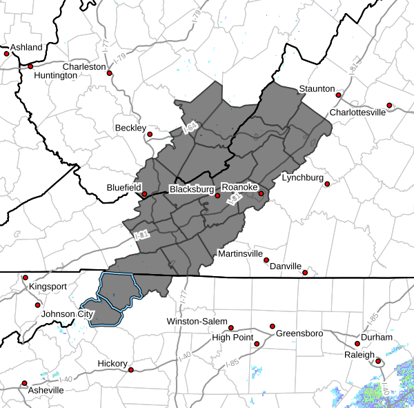
NCZ001-002-018-VAZ010>020-022>024-WVZ042>044-507-508-280345-
/O.NEW.KRNK.WI.Y.0005.250128T0500Z-250128T2000Z/
Ashe-Alleghany NC-Watauga-Bland-Giles-Wythe-Pulaski-Montgomery-
Grayson-Carroll-Floyd-Craig-Alleghany VA-Bath-Roanoke-Botetourt-
Rockbridge-Mercer-Summers-Monroe-Eastern Greenbrier-Western
Greenbrier-
Including the cities of West Jefferson, Whitetop, Quinwood,
Boone, Sparta, Galax, Floyd, Pulaski, Bland, Lewisburg, Salem,
New Castle, Wytheville, Buena Vista, Independence, Duo, White
Sulphur Springs, Hot Springs, Roanoke, Blacksburg, Lexington,
Pearisburg, Fincastle, Covington, Alderson, Rainelle, Flat Top,
Hix, Union, Troutdale, Radford, Hinton, Clifton Forge, Volney,
and Bluefield
244 PM EST Mon Jan 27 2025
…WIND ADVISORY IN EFFECT FROM MIDNIGHT TONIGHT TO 3 PM EST
TUESDAY…
- WHAT…West winds 15 to 30 mph with gusts of 40 to 50 mph expected.
- WHERE…Portions of northwest North Carolina, southwest and west
central Virginia, and southeast West Virginia. - WHEN…From midnight tonight to 3 PM EST Tuesday.
- IMPACTS…Gusty winds will blow around unsecured objects. Tree
limbs could be blown down and a few power outages may result. - ADDITIONAL DETAILS…The strongest wind gusts, up to 50 mph, are
expected at elevations above 3000 feet. The valleys will be
somewhat sheltered, with gusts up to 40 mph.
PRECAUTIONARY/PREPAREDNESS ACTIONS…
Winds this strong can make driving difficult, especially for high
profile vehicles. Use extra caution.