Last Updated on December 21, 2022 3:59 am
UPDATE Wednesday December 21 – Winter Weather Advisory goes into effect starting at 7pm this evening. More details at this link.
UPDATE Tuesday December 20 – Below is an update from the National Weather Service as of Tuesday afternoon.
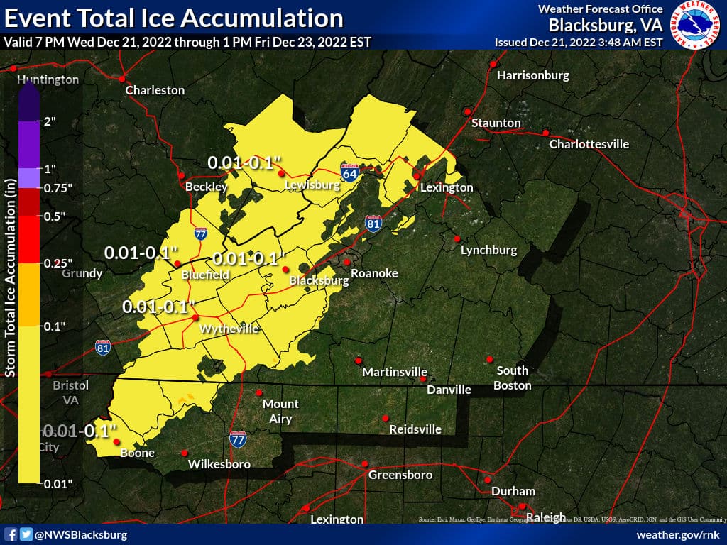
A light wintry mix is forecast late Wednesday night into Thursday morning which could result in a light glaze of ice. This may cause travel issues.
Arctic air arrives Friday with strong winds. Flash freezing of residual rain water onto roadway surfaces is likely. Accumulating snow showers are likely across the mountains and foothills. Wind chills Friday night into Sunday are expected to range from 0F to locally -20F.
Sunday December 18 – This week the High Country will experience some of the coldest temperatures of the entire year. Along with the bitter cold, wintery precipitation will be possible to varing degrees.
First to what is known for sure, it is about to get cold….really cold. As of the National Weather Service (NWS) forecast posted on Sunday evening, the coldest temperatures are expected Friday into Saturday.
Highs on Friday are forecast to drop from the lower 20s to around 10 above in the afternoon for most elevations, expect colder the higher up. Lows on Friday night zero to 5 above. Highs for Saturday in the mid-teens for most locations.
With wind gusts as high as 50 mph possible, wind chills are expected to be as low as 15 below on Friday, and as low as 20 below Friday night through Saturday night. For Christmas morning as low as 10 below.
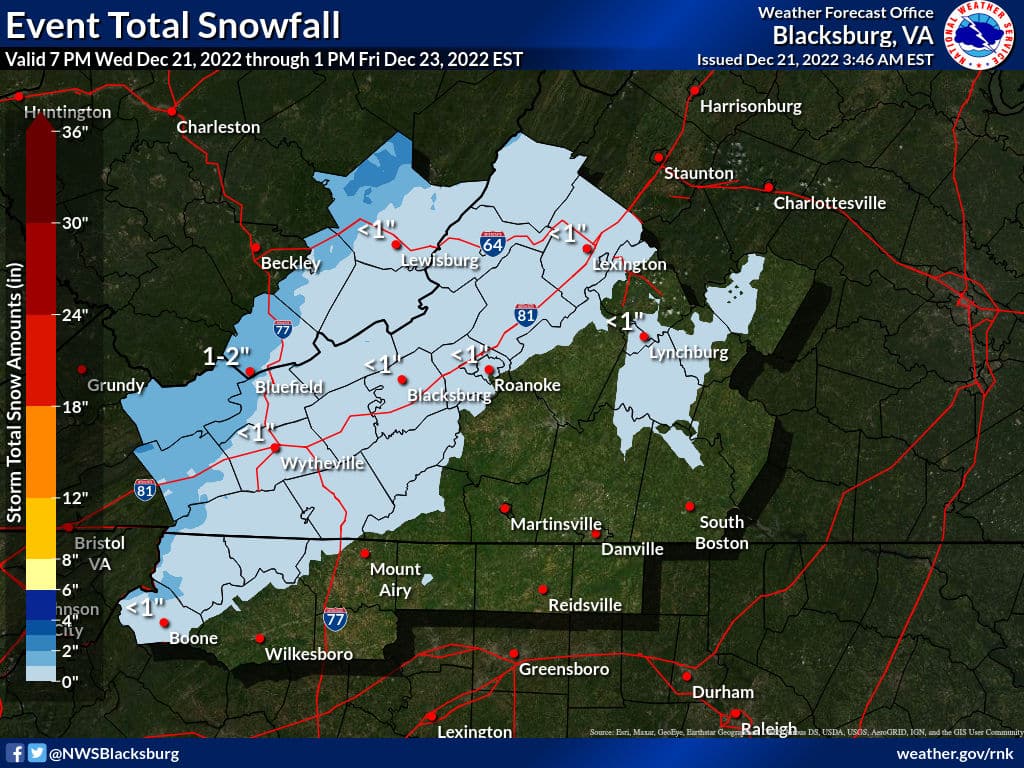
Now to the precipitation. The potential for a wintry mix exists for Wednesday night into Thursday, with accumulating snow possible Friday, according to NWS.
Wednesday night through Thursday night could see a grab bag of rain, freezing rain and snow. Forecast amounts should become more clear as two low pressure systems meet as the week progresses.
WataugaOnline.com will update all week long on the changing conditions.
Below is the NWS forecast for Watauga County as of Tuesday afternoon:
Rest Of Today
Mostly cloudy. Near steady temperature in the upper 30s. South winds around 5 mph.
Tonight
Partly cloudy in the evening, then clearing. Cold with lows in the mid 20s. East winds around 5 mph.
Wednesday
Sunny. Highs in the upper 30s. East winds 5 to 10 mph.
Wednesday Night
Mostly cloudy. Freezing rain with a chance of rain showers after midnight. Cold with lows in the upper 20s. Southeast winds 5 to 10 mph. Chance of precipitation 80 percent.
Thursday
Rain and freezing rain in the morning, then rain showers likely in the afternoon. Highs in the lower 40s. Southeast winds 5 to 10 mph with gusts up to 25 mph. Chance of precipitation 80 percent.
Thursday Night
Rain likely in the evening, then rain and snow after midnight. Little or no snow accumulation. Colder with lows 15 to 20. Chance of precipitation 90 percent.
Friday
Sunny. Snow in the morning. Little or no snow accumulation. Windy and much colder with highs in the lower 20s. Temperature falling to around 5 above in the afternoon. Chance of snow 90 percent. Wind chill values as low as 25 below.
Friday Night
Mostly clear in the evening, then becoming partly cloudy. Windy and much colder. Near steady temperature zero to 5 above zero. Wind chill values as low as 25 below.
Saturday And Saturday Night
Partly cloudy and blustery, cold. Highs 10 to 15. Lows zero to 5 above zero. Wind chill values as low as 25 below.
Christmas Day And Sunday Night
Mostly clear. Cold. Highs in the lower 20s. Lows around 10 above. Wind chill values as low as 15 below.
Monday
Mostly sunny. Cold with highs around 30. Wind chill values as low as zero in the morning.