Last Updated on February 12, 2022 6:26 pm
4:30am via twitter – All untreated surfaces including parking lots are frozen on and around campus, be careful @WataugaRoads
@WataugaRoads castle ford road coming to town, few slick spots around curves and black ice.
"Reports that freezing rain starting in the Foscoe area. Use caution driving tonight please."
New event. Winter Storm Warning from 2/26/2013 4:52 AM to 9:00 AM EST for Avery County, Caldwell County.http://1.usa.gov/XyPG1d
5am from facebook – “105 bypass is awful as of 5 am”
5:08am from facebook - West Jefferson Icy, Icy,Icy. Nice layer of ice on the car. Roads are icy use caution!
School closings and delays can be found here http://wataugaroads.com/closingscancellations/
5:40am – it's a good morning to delay that early morning travel (if you can) as freezing rain continues to fall. Allow plenty of extra time
5:40am per facebook “It's a mess out in the Deep Gap area…I won't be on the road for a while!”
5:50am from facebook – Very icy on Meat Camp Rd
6am from facebook “Deep Gap to West Jefferson. Roads mostly slush with it being sleet mix”
All ASU classes that meet on main campus before 11 a.m. Tuesday, Feb. 26, have been
canceled. An update will be issued at 9 a.m. if weather conditions change. – http://wataugaroads.com/closingscancellations/
Tuesday 26, 2013 AppalCART will be on a 3 hour delay routes will start at 10am with no county routes.
6:13am from facebook report “321N from avery line to 421 skateworld ice in spots. 421 skateworld to hilltop just wet. hilltop and threw boone covered with 1/2 to 1 inch ice on roads (VERY SLICK). still sleeting and freezing rain hard in boone”
6:20am from facebook report “Bamboo to Deerfield is very very icy” “Clint Norris Road, very icy as parts of 194”
6:30am – power outages in the Blue Ridge Electric member area – Caldwell 15
6:45am – scanner reports have been light, either motorist are waiting to travel for the most part or taking it easy driving
6:45am – 105 bypass slushy per facebook report
6:51am – Slick spots on 321 at the Elk Motel, use caution
6:53am – getting reports of lots of standing water on Blowing Rock Road near Cookout
Report from Darren Mullenix – 6:35am. 421 from Deep Gap is slushy but passable. Took the long way this morning . 105 ext is wet and slushy. State Farm is slushy. Caution on the downhill both directions. Deerfield passable through the S bends but getting slick. It looked like traffic on Wilson's Ridge was backed up and stopped for some reason. Bamboo at airport ok but slushy. Slick spots abound. Be careful out there.
7:07am – power outages in the Blue Ridge Electric member area – Caldwell 26
King Street has that glazed/mix look to it at 7:13am. Photo:Resortcams.com & http://wataugaroads.com/cams/

Winter Storm Warning remains until noon, High Wind Warning until 7pm tonight
NWS Weather Spotter report – 2 W Boone [Watauga Co, NC] trained spotter reports FREEZING RAIN of M0.25 INCH at 07:00 AM EST bit.ly/ZxoeQK?RNK
7:30am – 38 degrees in Beaver Dam, 30 in Boone
7:28am – ice on power line from downtown Blowing Rock. Photo:Resortcams.com &wataugaroads.com/cams/

Icy Willow Tree, Photo: Charlie Weaver

Currently no operations scheduled on 321 in Blowing Rock due to weather. Slow down, stay alert. Call 828-964-3260 for project information.
7:45am – power outages in the Blue Ridge Electric member area – Caldwell 22, Watauga 1
Avery County Schools are now closed for students and staff – 7:50am
7:55am per facebook report “321 up from lenoir slushy and slick spots. Standing water”
8am – it appears freezing rain will continue across the area until around noon. Main roads are reported wet/slushy. Secondary roads, even in Boone, are reported to be the problem areas. Take your time.
8:08am from facebook report “421 from TN state line to Boone just wet until you get to 105 bypass then slushy all the way into town. Did not seem slick but travel with caution”
From Brad Panovich “Jefferson with .20" Ice accretion along with .25" in Boone and .25" Fairview, NC”
8:25am – power outages in the Blue Ridge Electric member area – Caldwell 362, Ashe 30, Watauga 5
7:45am view of ASU. Photo: Carolene Mcglamery

Photo from ASU by Tina Parlier

This morning in Deep Gap. Photo Annkatrin Rose

8:50am – power outages in the Blue Ridge Electric member area – Caldwell 385, Ashe 47, Watauga 27, Alleghany 1
ASU Classes that meet at 11 a.m. or later will be held as scheduled today, Feb. 26.
Watauga Campus of Caldwell Community College will open at noon
9:17am – still looks icy on surfaces in downtown Blowing Rock. Photo:Resortcams.com & http://wataugaroads.com/cams/


9:21am – power outages in the Blue Ridge Electric member area – Watauga 340, Caldwell 416, Ashe 48
Event extended (time). Winter Storm Warning from 2/26/2013 9:22 AM to 2:00 PM EST for Ashe County, Watauga County.http://1.usa.gov/Xzr48B
Photo:Morris Hampton

Photo: Karen Petrey

In Deep Gap. Photo: Laurie Bienko

9:41am – power outages in the Blue Ridge Electric member area – Watauga 338, Caldwell 682, Ashe 66
9:42am – via Boone Police – Still raining/sleeting here in town. Temps are still below freezing. Plan for extra travel time use caution and slow down.
In Blowing Rock. Photo: Teresa Cook

9:49am – power outages in the Blue Ridge Electric member area – Watauga 5, Caldwell 822, Ashe 104
*UPDATED 9:55am with new information from Watauga County Schools* Watauga County Schools To Operate Saturday March 2http://wataugaroads.com/watauga-county-schools-to-operate-saturday-march-2/
Radar view of the difference in freezing rain falling at 9:35am and just before 10am


Photos by Jill Green


ASU campus at 10:30am. Photo: Lindsey Carter

10:35am – power outages in the Blue Ridge Electric member area – Watauga 33, Caldwell 758, Ashe 121, Avery 13, Wilkes 1
AppalCart Silver route will not be going up White Oak this morning
10:50am – power outages in the Blue Ridge Electric member area – Watauga 70, Caldwell 391, Ashe 121, Avery 13, Wilkes 6
via Boone PD at 10:55am – We are starting to get reports of minor accidents in Town. Stay home if possible. Use caution and slow down otherwise.
11:11am – power outages in the Blue Ridge Electric member area – Watauga 92, Caldwell 386, Ashe 9, Wilkes 6
via Boone PD at 11:44am – Officers are out with a tree in the roadway Hwy 105 near Ross. Please use caution in the area.
11:55am – power outages in the Blue Ridge Electric member area – Watauga 128, Caldwell 255, Wilkes 7, Alleghany 127
12noon – looks like we are getting out of the heavy freezing rain now. Winter Storm Warning still up until 2pm, High Wind Warning til 7pm, wind gusts up to 40mph possible. Rain still in the forecast for the rest of today and snow showers after midnight.
12:04pm twitter report of “tree also down on 105 bypass in left lane when heading towards Caldwell community college”
Boone Mall 1:15pm. Photo: Anita Presnell
2:00pm – power outages in the Blue Ridge Electric member area – Watauga 163, Caldwell 229, Wilkes 434, Alleghany 71, Ashe 986
As of 2:10pm the temps can not seem to get above 32 in Boone. Elsewhere in the county it's mid to upper 30s for the most part
Laura Sharpe sends in this look at campus around 1:30

Photo by Anita Presnell on 105 this afternoon

Winter Storm Warning has been extended until 6pm for the following counties:ASHE-ALLEGHANY NC-WATAUGA-GRAYSON-CARROLL-FLOYD
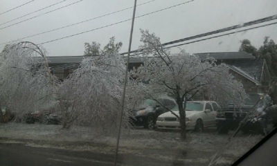
Icy still in Deep Gap. Photo: Olivia Bryant

2:40pm – power outages in the Blue Ridge Electric member area – Watauga 155, Caldwell 214, Wilkes 1
2:46pm – scanner report of a tree down on 321 near Aho Road, good portion of the road affected, use caution
3pm – power outages in the Blue Ridge Electric member area – Watauga 225, Caldwell 205, Wilkes 1
We have finally cleared out most of the freezing rain/rain in the area, however temps in Boone still at 32 wataugaroads.com/radar/
rainbow in Zionville. Photo:LeAnn Martin

4:10pm– power outages in the Blue Ridge Electric member area – Watauga 1,163, Caldwell 162, Ashe 9, Wilkes 1
Boone Park, Photo: Olivia Bryant

4:55pm– power outages in the Blue Ridge Electric member area – Watauga 178, Caldwell 48
5:25pm– power outages in the Blue Ridge Electric member area – Watauga 178
Avery County Schools will operate on a 2 hour delay on Wednesday. Faculty and staff are to report on a regular schedule if it is safe for them to do so
With temps forecast for the lower 30s tonight/overnight be mindful of black ice if traveling.
Aho Road. Photo: Brandy Black

Watauga County Schools will operate on a 2 hour delay with limited bus routes on Wednesday – http://wataugaroads.com/closingscancellations/
Event cancelled. High Wind Warning from 2/26/2013 5:58 PM to 7:00 PM EST for Ashe County, Watauga County. http://1.usa.gov/YWO2Vx