Last Updated on May 31, 2022 11:42 am
NCC171-193-197-270015-
/O.NEW.KRNK.TO.W.0024.220526T2351Z-220527T0015Z/
BULLETIN – EAS ACTIVATION REQUESTED
Tornado Warning
National Weather Service BLACKSBURG VA
751 PM EDT Thu May 26 2022
The National Weather Service in BLACKSBURG has issued a
- Tornado Warning for…
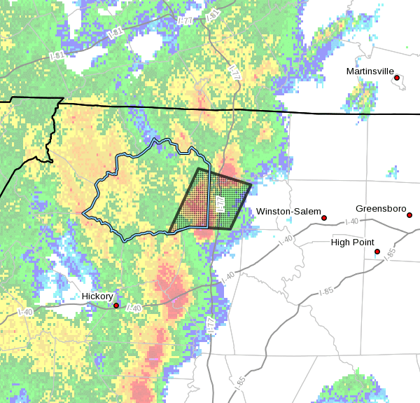
South central Surry County in northwestern North Carolina…
Southeastern Wilkes County in northwestern North Carolina…
Western Yadkin County in northwestern North Carolina… - Until 815 PM EDT.
- At 751 PM EDT, a severe thunderstorm capable of producing a tornado
was located near Buck Shoals, or 9 miles south of Ronda, moving
north at 35 mph.
HAZARD…Tornado and quarter size hail.
SOURCE…Radar indicated rotation.
IMPACT…Flying debris will be dangerous to those caught without
shelter. Mobile homes will be damaged or destroyed.
Damage to roofs, windows, and vehicles will occur. Tree
damage is likely.
- Locations impacted include…
Elkin…
Jonesville…
Boonville…
Ronda…
Windy Gap…
Buck Shoals…
and Pleasant Hill.
PRECAUTIONARY/PREPAREDNESS ACTIONS…
TAKE COVER NOW! Move to a basement or an interior room on the lowest
floor of a sturdy building. Avoid windows. If you are outdoors, in a
mobile home, or in a vehicle, move to the closest substantial shelter
and protect yourself from flying debris.
Tornadoes are extremely difficult to see and confirm at night. Do not
wait to see or hear the tornado. TAKE COVER NOW!
When it is safe to do so, please send your reports of hail of any
size, as well as reports of any wind damage, including downed trees
or large limbs, to the National Weather Service by calling toll free
at 1…8 6 6…2 1 5…4 3 2 4. Reports and pictures can also be
shared on the National Weather Service Blacksburg Facebook page and
on Twitter.
&&
LAT…LON 3603 8109 3631 8093 3624 8065 3605 8076
3606 8098 3604 8104 3603 8106
TIME…MOT…LOC 2351Z 202DEG 31KT 3610 8090
TORNADO…RADAR INDICATED
MAX HAIL SIZE…1.00 IN