Last Updated on August 7, 2021 4:51 pm
NCC005-009-189-193-072145-
/O.NEW.KRNK.SV.W.0129.210807T2047Z-210807T2145Z/
BULLETIN – IMMEDIATE BROADCAST REQUESTED
Severe Thunderstorm Warning
National Weather Service BLACKSBURG VA
447 PM EDT Sat Aug 7 2021
The National Weather Service in BLACKSBURG has issued a
- Severe Thunderstorm Warning for…
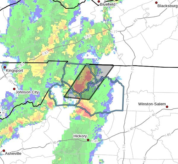
Alleghany County in northwestern North Carolina…
Northwestern Wilkes County in northwestern North Carolina…
East central Watauga County in northwestern North Carolina…
Central Ashe County in northwestern North Carolina… - Until 545 PM EDT.
- At 447 PM EDT, severe thunderstorms were located along a line
extending from near Piney Creek to near Todd, moving east at 10
mph.
HAZARD…60 mph wind gusts and quarter size hail.
SOURCE…Radar indicated.
IMPACT…Hail damage to vehicles is expected. Expect wind damage
to roofs, siding, and trees.
- Locations impacted include…
Boone…
Sparta…
Jefferson…
West Jefferson…
Glendale Springs…
Deep Gap…
and Mc Grady.
This includes The following Location Appalachian State University.
PRECAUTIONARY/PREPAREDNESS ACTIONS…
Prepare immediately for large hail and damaging winds. For your
safety, move to an interior room on the lowest floor of a sturdy
building. Stay away from windows.
Torrential rainfall is occurring with these storms, and may lead to
flash flooding. Do not drive your vehicle through flooded roadways.
When it is safe to do so, please send your reports of hail of any
size, as well as reports of any wind damage, including downed trees
or large limbs, to the National Weather Service by calling toll free
at 1…8 6 6…2 1 5…4 3 2 4. Reports and pictures can also be
shared on the National Weather Service Blacksburg Facebook page and
on Twitter.