







Last Updated on November 9, 2026 7:35 am
The first taste of winter is on the way to the High Country. After a stretch of mild, dry weather, the National Weather Service says the coldest air of the season arrives late this week, along with a chance of upslope snow in the mountains.
What the National Weather Service is saying
In its forecast discussion issued Monday morning, the National Weather Service office in Blacksburg, Va., said above-normal temperatures and dry weather will continue through midweek, with highs climbing into the 60s and 70s, about 10 to 15 degrees above normal.
A low pressure system and a deep upper-level trough then move in late in the week. Rain chances arrive Thursday, and the forecaster said the system will bring “the coldest air of the season” along with upslope snow potential in the mountains.
Forecasters say some upslope snow will be possible in the western mountains, but confidence is low on how much will fall and how far south the snow could reach. Computer models differ on where the low pressure system redevelops Friday, which will determine how much wraparound moisture is available.
For most of the area, the bigger story is the cold. Highs will be in the 40s and 50s from Friday through the weekend, and most of the mountains could see their first hard freeze of the year, with lows in the mid 20s. Drier, more seasonable weather returns early next week.
The latest point forecast for Boone, updated Sunday evening, shows rain likely Thursday (60% chance) with a high near 55, a chance of rain turning to a rain and snow mix Thursday night with a low around 26, a chance of snow (30%) Friday with a high near 40, and another chance of snow Friday night with a low around 22. Saturday looks mostly sunny and breezy with a high near 40, and Sunday looks sunny with a high near 49.
No watches or warnings have been issued for the High Country at this time. Forecast courtesy of the National Weather Service.
What NBC Charlotte’s models show
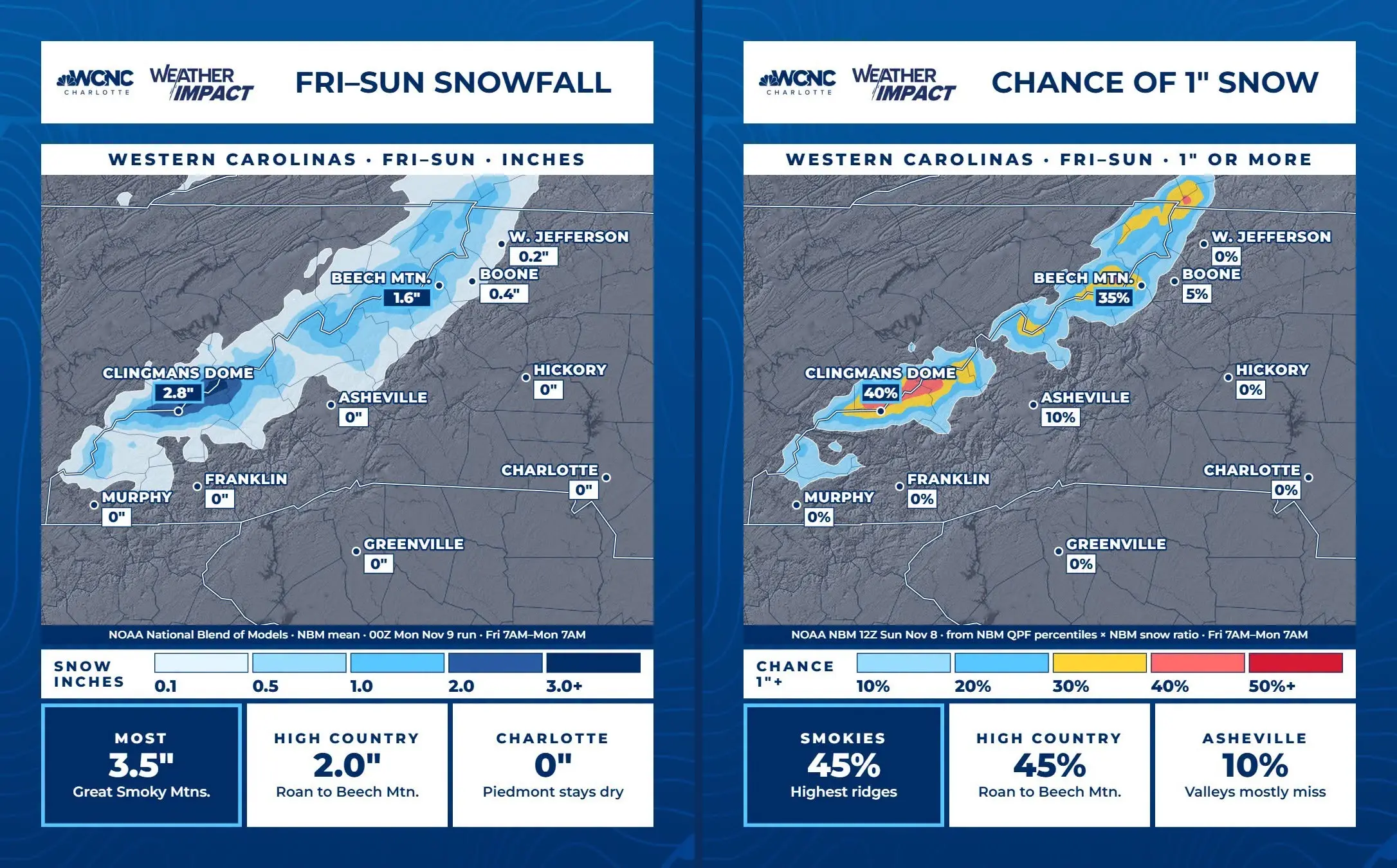
NBC Charlotte Chief Meteorologist Brad Panovich shared two new Weather Impact graphics built from NOAA’s National Blend of Models for the period from 7 a.m. Friday through 7 a.m. Monday.
The first graphic shows the chance of at least 1 inch of snow. It puts the odds at 45% from Roan Mountain to Beech Mountain and 35% at Beech Mountain. Boone is at 5%, and West Jefferson is at 0%. The highest ridges of the Smokies also show a 45% chance.
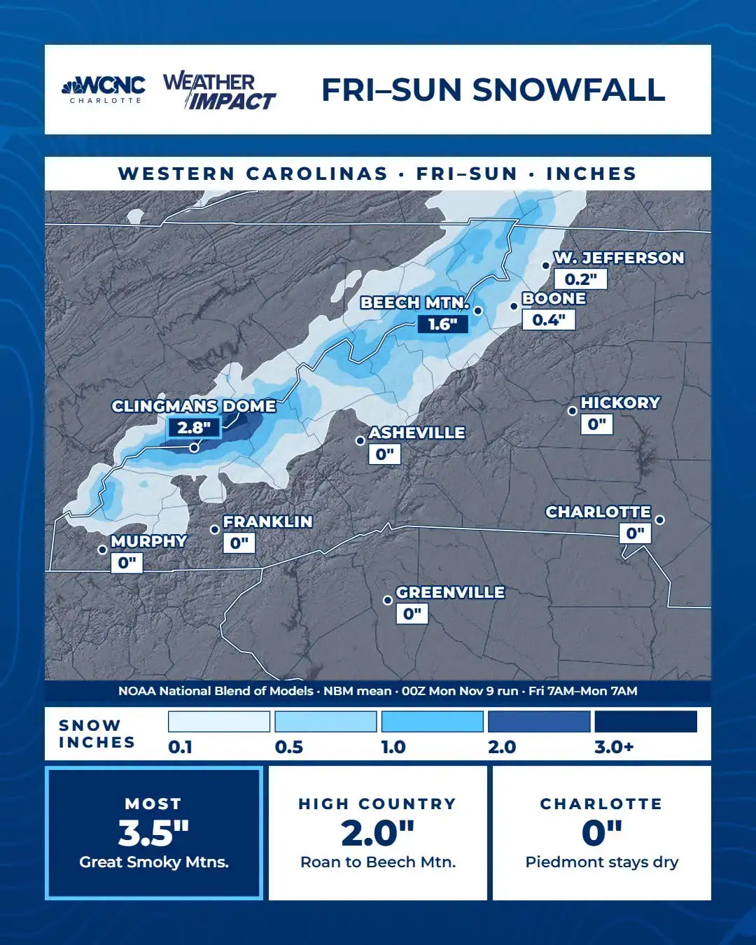
The second graphic shows projected totals. The High Country, from Roan to Beech Mountain, could see about 2.0 inches of snow, with about 1.6 inches at Beech Mountain. Boone shows about 0.4 inches and West Jefferson about 0.2 inches. The Great Smoky Mountains could see the most, up to about 3.5 inches, and the valleys mostly miss out.
Panovich said snow chances look confined to areas favored by northwest flow, with the Smokies and the area around Beech Mountain having the highest chances. He called it a typical November setup for the mountains and cautioned against putting too much weight on single computer model runs, saying the full set of data and ensembles should be considered together.
What it means
The highest elevations stand the best chance of seeing accumulating snow, while lower towns like Boone and West Jefferson are expected to see little to none. Forecasters say confidence is still low on amounts and exactly where the snow falls. These are model projections, not an official forecast, and details can change as the event gets closer.
Stay with WataugaOnline for updates as the forecast develops.