Last Updated on October 14, 2015 2:28 pm
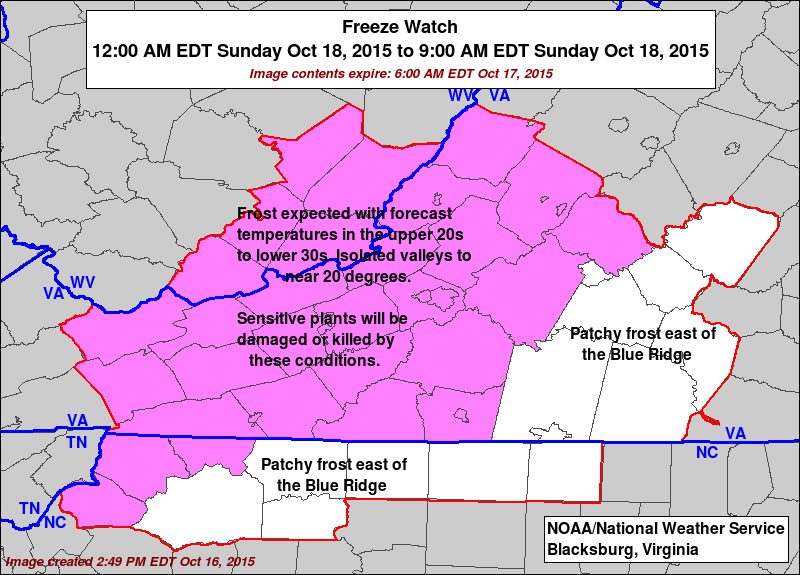
UPDATE SATURDAY – The National Weather Service has issued a Freeze Warning, along with a Freeze Watch.
…FREEZE WARNING IN EFFECT FROM MIDNIGHT TONIGHT TO 9 AM EDT
SUNDAY…
…FREEZE WATCH IN EFFECT FROM LATE SUNDAY NIGHT THROUGH MONDAY
MORNING…
THE NATIONAL WEATHER SERVICE IN BLACKSBURG HAS ISSUED A FREEZE
WARNING…WHICH IS IN EFFECT FROM MIDNIGHT TONIGHT TO 9 AM EDT
SUNDAY. A FREEZE WATCH HAS ALSO BEEN ISSUED. THIS FREEZE WATCH IS
IN EFFECT FROM LATE SUNDAY NIGHT THROUGH MONDAY MORNING.
* LOCATIONS…FROM THE MOUNTAINS TO THE FOOTHILLS OF THE BLUE
RIDGE.
* HAZARDS…FREEZING TEMPERATURES INCLUDING AREAS OF FROST.
* TEMPERATURES…MAINLY IN THE UPPER 20S TO LOWER 30S TONIGHT AND
MID TO UPPER 20S SUNDAY NIGHT.
* TIMING…LATE TONIGHT INTO EARLY SUNDAY MORNING AND AGAIN LATE
SUNDAY NIGHT INTO EARLY MONDAY MORNING.
* IMPACTS…SENSITIVE VEGETATION WILL BE DAMAGED OR KILLED.
PRECAUTIONARY/PREPAREDNESS ACTIONS…
A FREEZE WARNING MEANS SUB-FREEZING TEMPERATURES ARE IMMINENT OR
HIGHLY LIKELY. THESE CONDITIONS WILL KILL CROPS AND OTHER
SENSITIVE VEGETATION.
A FREEZE WATCH MEANS SUB-FREEZING TEMPERATURES ARE POSSIBLE.
THESE CONDITIONS COULD KILL CROPS AND OTHER SENSITIVE VEGETATION.
UPDATE Friday – A Freeze Watch is in effect from late Saturday night through Sunday morning.
* HAZARDS…FREEZING TEMPERATURES AND AREAS OF FROST.
* TEMPERATURES…IN THE UPPER 20S TO LOW 30S.
* TIMING…MIDNIGHT TO 9 AM SUNDAY MORNING.
* IMPACTS…SENSITIVE VEGETATION WILL BE DAMAGED OR KILLED.
PRECAUTIONARY/PREPAREDNESS ACTIONS…
A FREEZE WATCH MEANS SUB-FREEZING TEMPERATURES ARE POSSIBLE.
THESE CONDITIONS COULD KILL CROPS AND OTHER SENSITIVE VEGETATION.
With much cooler low temperatures this weekend, the High Country could see it's first frost/freeze of the 2015 fall season.
The coldest air of the season is set to move in with freezing temperatures now appearing fairly likely in western mountain valleys and higher elevations by Sunday, according to the National Weather Service. Canadian high pressure will settle across the region on Saturday and Sunday nights resulting in temperatures falling into the upper 20s and low 30s, the Weather Service notes in their weekend weather outlook.
UPDATE Thursday night – NWS adds in their Thursday update “Minimum temperatures Saturday night and Sunday night will be in the mid 20s to mid 30s…Therefore a hard freeze is expected…As well as widespread frost.”
Even though there were officially lows in the upper 30s for a few days in September for Boone, the last time lows were in the low 30s was early May (33 two consecutive mornings), and the last week of April (30 for two consecutive mornings).
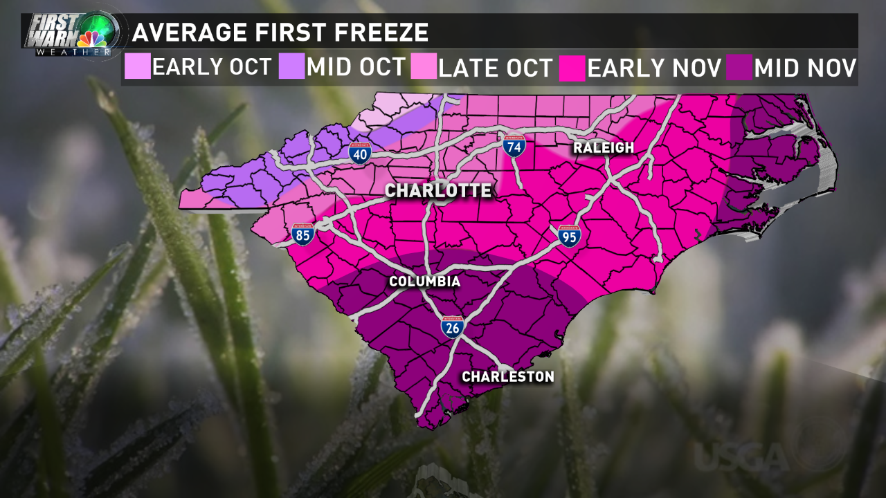
Graphic: Brad Panovich, NBC Charlotte
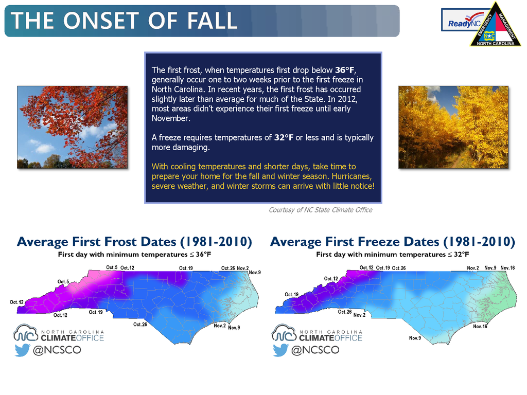
Graphic: North Carolina Emergency Management