Last Updated on March 27, 2025 6:27 pm
Hurricane Helene Local Statement Advisory Number 10
National Weather Service Greenville-Spartanburg SC AL092024
524 PM EDT Wed Sep 25 2024
This product covers the western Carolinas and NE Georgia
**HELENE TO BRING SIGNIFICANT FLASH FLOODING AND STRONG WIND GUSTS TO
THE WESTERN CAROLINAS AND NORTHEAST GEORGIA**
NEW INFORMATION
—————
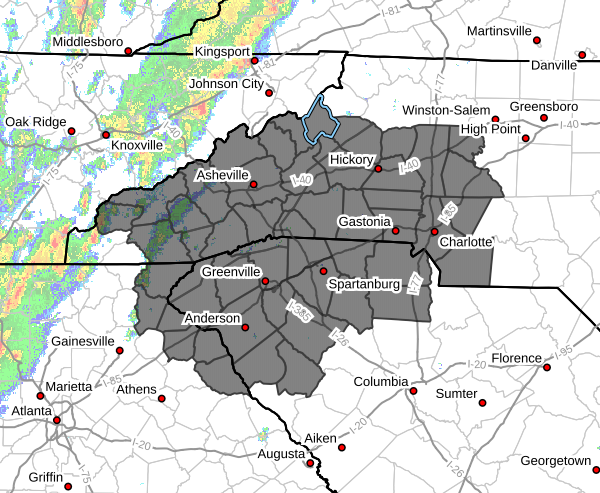
* CHANGES TO WATCHES AND WARNINGS:
– The Tropical Storm Watch has been upgraded to a Tropical Storm
Warning for Abbeville, Anderson, Avery, Buncombe, Burke
Mountains, Caldwell Mountains, Central Greenville, Cherokee,
Cleveland, Eastern McDowell, Eastern Polk, Elbert, Franklin,
Graham, Greater Burke, Greater Caldwell, Greater Oconee,
Greater Pickens, Greater Rutherford, Greenville Mountains,
Greenwood, Habersham, Hart, Haywood, Henderson, Laurens, Macon,
Madison, McDowell Mountains, Mitchell, Northern Jackson,
Northern Spartanburg, Oconee Mountains, Pickens Mountains, Polk
Mountains, Rabun, Rutherford Mountains, Southern Greenville,
Southern Jackson, Southern Spartanburg, Stephens, Swain,
Transylvania, Union SC, and Yancey
– A Tropical Storm Warning has been issued for Catawba, Chester,
Gaston, Lincoln, Mecklenburg, Union NC, and York
* CURRENT WATCHES AND WARNINGS:
– A Tropical Storm Warning is in effect for Abbeville, Anderson,
Avery, Buncombe, Burke Mountains, Caldwell Mountains, Catawba,
Central Greenville, Cherokee, Chester, Cleveland, Eastern
McDowell, Eastern Polk, Elbert, Franklin, Gaston, Graham,
Greater Burke, Greater Caldwell, Greater Oconee, Greater
Pickens, Greater Rutherford, Greenville Mountains, Greenwood,
Habersham, Hart, Haywood, Henderson, Laurens, Lincoln, Macon,
Madison, McDowell Mountains, Mecklenburg, Mitchell, Northern
Jackson, Northern Spartanburg, Oconee Mountains, Pickens
Mountains, Polk Mountains, Rabun, Rutherford Mountains,
Southern Greenville, Southern Jackson, Southern Spartanburg,
Stephens, Swain, Transylvania, Union NC, Union SC, Yancey, and
York
* STORM INFORMATION:
– About 940 miles south-southwest of Charlotte NC or about 900
miles south-southwest of Greenville/Spartanburg SC
– 22.5N 86.6W
– Storm Intensity 85 mph
– Movement North or 355 degrees at 12 mph
SITUATION OVERVIEW
——————
Hurricane Helene is expected to make landfall over the Florida
Panhandle Thursday evening and race north into Georgia and the western
Carolinas. Significant flash flooding and mainstem flooding is likely
Thursday into early Friday, especially along the Blue Ridge
Escarpment. Wind gusts of 40-50 MPH will be associated with Helene as the
storm tracks just west of the County Warning Area Thursday night into
Friday morning. The combination of saturated soils and strong wind
gusts will result in numerous trees down, leading to numerous power
outages. Numerous landslides may occur across the mountains, with a
couple of large, damaging debris flows/slope failures. An isolated
tornado or two can't be ruled out during this event as well.
POTENTIAL IMPACTS
—————–
* FLOODING RAIN:
Protect against life-threatening rainfall flooding having possible
devastating impacts across the North Carolina mountains, northeast
Georgia, and Upstate South Carolina. Potential impacts include:
– Extreme rainfall flooding may prompt numerous evacuations and
rescues.
– Rivers and tributaries may overwhelmingly overflow their banks
in many places with deep moving water. Small streams, creeks,
canals, arroyos, and ditches may become raging rivers. In
mountain areas, deadly runoff may rage down valleys while
increasing susceptibility to rockslides and mudslides. Flood
control systems and barriers may become stressed.
– Flood waters can enter numerous structures within multiple
communities, some structures becoming uninhabitable or washed
away. Numerous places where flood waters may cover escape
routes. Streets and parking lots become rivers of raging water
with underpasses submerged. Driving conditions become very
dangerous. Numerous road and bridge closures with some weakened
or washed out.
* WIND:
Protect against hazardous wind having possible limited impacts across most
of the western Carolinas and northeast Georgia. Potential impacts
include:
– Damage to porches, awnings, carports, sheds, and unanchored
mobile homes. Unsecured lightweight objects blown about.
– Many large tree limbs broken off. A few trees snapped or
uprooted, but with greater numbers in places where trees are
shallow rooted. Some fences and roadway signs blown over.
– A few roads impassable from debris, particularly within urban
or heavily wooded places. Hazardous driving conditions on
bridges and other elevated roadways.
– Scattered power and communications outages.
* TORNADOES:
Protect against a tornado event having possible limited impacts
across the western Carolinas and NE Georgia. Potential impacts
include:
– The occurrence of isolated tornadoes can hinder the execution
of emergency plans during tropical events.
– A few places may experience tornado damage, along with power
and communications disruptions.
– Locations could realize roofs peeled off buildings, chimneys
toppled, mobile homes pushed off foundations or overturned,
large tree tops and branches snapped off, shallow-rooted trees
knocked over, moving vehicles blown off roads, and small boats
pulled from moorings.
PRECAUTIONARY/PREPAREDNESS ACTIONS
———————————-
* EVACUATIONS:
Follow the advice of local officials.
* OTHER PREPAREDNESS INFORMATION:
Now is the time to complete all preparations to protect life and
property in accordance with your emergency plan. Ensure you are in a
safe location before the onset of strong winds or possible flooding.
It is important to remain calm, informed, and focused during an
emergency. Be patient and helpful with those you encounter.
Rapidly rising flood waters are deadly. If you are in a flood-prone
area, consider moving to higher ground. Never drive through a flooded
roadway. Remember, turn around don't drown!
If a Tornado Warning is issued for your area, be ready to shelter
quickly, preferably away from windows and in an interior room not
prone to flooding. If driving, scan the roadside for quick shelter
options.
Closely monitor weather.gov, NOAA Weather radio or local news outlets
for official storm information. Be ready to adapt to possible changes
to the forecast. Ensure you have multiple ways to receive weather
warnings.
* ADDITIONAL SOURCES OF INFORMATION:
– For information on appropriate preparations see ready.gov
– For information on creating an emergency plan see getagameplan.org
– For additional disaster preparedness information see redcross.org
NEXT UPDATE
———–
The next local statement will be issued by the National Weather
Service in Greenville-Spartanburg SC around 11 AM EDT, or sooner if
conditions warrant.


