Last Updated on April 25, 2018 1:55 pm
Some locations in Watauga County recorded over 6 inches of rain during this week's storms.
The National Weather Service in their 48 hour rainfall totals, ending 10:28am Wednesday morning, notes that 6.02 inches fell in the Aho community. That is followed by: 5.78 at the 1 E Seven Devils station, 5.68 in Rutherwood, 5.56 at 1 ESE Boone, 5.27 at 1 WNW Blowing Rock.
The 2 NE Deep Gap weather station in Ashe County recorded 6.69 inches, that's the most in the entire NWS-Blacksburg coverage area.
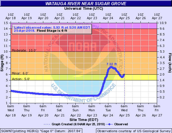
The Watauga River in Sugar Grove maxed out at 7.32 feet at 10:34 am on Tuesday morning.
Other reports across Watauga County:
Location Amount Time/Date Provider
Boone 1se 4.91 in 0700 AM 04/25 COOP
Boone Precip (tva) 2s 4.35 in 1015 AM 04/25 GOES
1 NNW Boone 4.18 in 0700 AM 04/25 COCORAHS
Boone 4.12 in 1010 AM 04/25 CWOP
1 ENE Foscoe 3.71 in 0915 AM 04/25 IFLOWS
1 WNW Aho 3.48 in 0700 AM 04/25 IFLOWS
1 N Foscoe 3.17 in 0800 AM 04/25 COCORAHS
Valle Crucis 3.13 in 0700 AM 04/24 COCORAHS
Watauga River 3.11 in 0930 AM 04/25 GOES
2 W Blowing Rock 3.08 in 1018 AM 04/25 CWOP
1 ESE Boone 3.04 in 0755 AM 04/25 AWOS
1 NNW Beech Mountain 2.83 in 1019 AM 04/25 CWOP
1 W Reese 1.67 in 0700 AM 04/25 COCORAHS
1 W Reese 1.65 in 0700 AM 04/25 COCORAHS
3 SSE Foscoe 1.18 in 1012 AM 04/25 CWOP
2 SSW Rominger 0.76 in 1019 AM 04/25 CWOP