Last Updated on January 22, 2016 6:00 am
Below are updates regarding the winter storm impacts to Watauga County. The page will continuously be updated.
6am – First reports of snow came in around 2:30am from a law enforecement officer in Boone. At that time he reported heavy snow and snow covered roads. Numerous accidents already reported via twitter.
6:51am – NWS Storm spotter in Valle Crucis reports 3 inches of snow in four hours. Spotter in Rutherwood reports 3.5 inches
7:37am – NWS spotter reports 4.8 inches in Blowing Rock as of 7:27am.
8:20am – It appears that many motorist took the advice of officials and stayed off the roads this morning. Not hearing any accident reports on the scanner at this time.
Morning Weather VLOG and Update: Don't let your guard down the worst is yet to come. #cltwx #ncwx #scwx
Posted by Brad Panovich Meteorologist on Friday, January 22, 2016
10:26am – Main roads are snow covered but passable for the most part, according to incoming reports. However we are expecting snowfall to increase dramatically today, so conditions will go downhill quickly. Be aware of changing conditions.
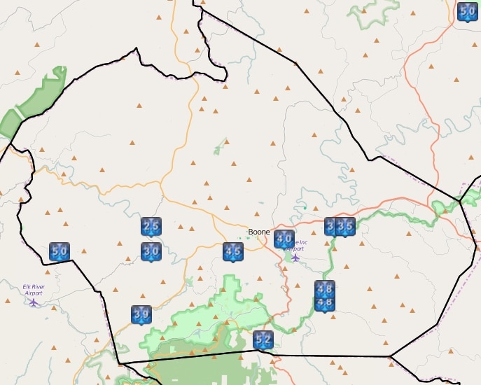
Snow Reports from the National Weather Service through 10:17am Friday
North Carolina Governor Pat McCrory press conference on the storm
Video update from National Weather Service
1:24pm – Not a lot of change to the 10:26pm update posted above. Live camera feeds show 105 in Foscoe still covered for the most part, with some tire tracks starting to show in the northbound lane. Blowing snow in Boone is still causing streets in downtown to be covered.
The National Weather Service has updated the afternoon and night forecast to reflect a little less snow fall totals, 2-4 for afternoon and 2-4 more for tonight. However they have included now the possibility of sleet for today. Total accumulations through Sunday of 18-24 are still forecast by NWS. The storm is expected to start producing accumulating snow again this afternoon.
1:52pm – Several reports of sleet falling across the county are coming in. Be aware of changing conditions and impacts to travel.
2:04pm – Officials with Boone Police and the Emergency Management Office have received several calls asking about a curfew being imposed. Both report there are no curfews, or planned curfews at this time.
2PM Weather Update: More on the way. #cltwx #ncwx #scwx
Posted by Brad Panovich Meteorologist on Friday, January 22, 2016
4pm – Heavy snow continues in waves across the county. Roads, as they have been all day, continue to be snow covered. With the heavier snow bands moving in wind gusts are forecast to increase up to 35mph tonight. White out conditions may be possible at times with the blowing snow. Travel is not advised.
INCOMING REPORTS VIA TWITTER. FEED WILL AUTOMATICALLY UPDATE AS NEW ITEMS ARE POSTED