Last Updated on February 13, 2022 8:48 am
NCC189-172345-
/O.NEW.KRNK.FA.W.0059.180917T2154Z-180917T2345Z/
/00000.0.ER.000000T0000Z.000000T0000Z.000000T0000Z.OO/
Watauga NC-
554 PM EDT MON SEP 17 2018
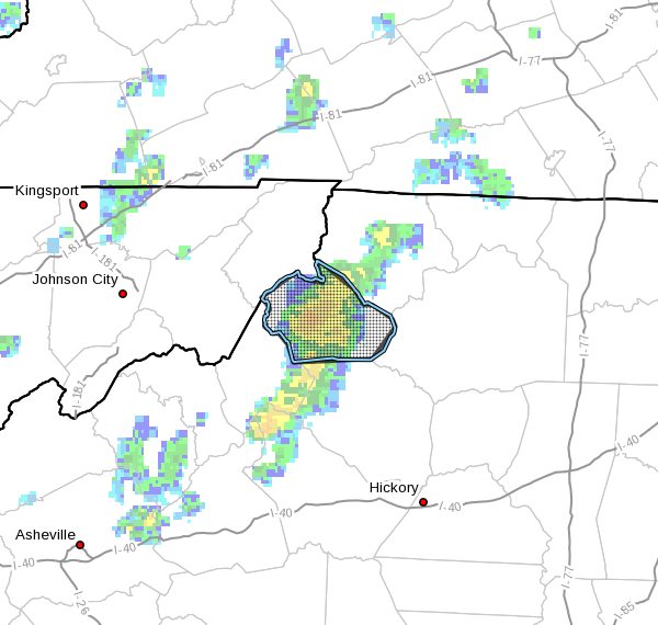
The National Weather Service in BLACKSBURG has issued a
* Flood Warning for…
Watauga County in northwestern North Carolina…
* Until 745 PM EDT
* At 552 PM EDT, Doppler radar indicated a slow moving area of heavy
rainfall affecting much of Watauga County. The ground in this
area is completely saturated from recent rainfall and rainfall
associated with Hurricane Florence over the past few days.
Additional heavy rain will quickly resulting in flooding of low-
lying, poor drainage, and normally flood prone areas.
* Some locations that may experience renewed flooding include…
Boone…
Blowing Rock…
Beech Mountain…
Foscoe…
and Sugar Grove.
Additional rainfall amounts of 1 inch or more are possible in the
warned area.
This includes the following streams and drainages…
Stony Fork…
Meat Camp Creek…
Vanderpool Creek…
Watauga River…
and Craborchard Creek.
This includes The following Location Appalachian State University.
PRECAUTIONARY/PREPAREDNESS ACTIONS…
In hilly terrain there are hundreds of low water crossings which are
potentially dangerous in heavy rain. Do not attempt to cross flooded
roads. Find an alternate route.
A Flood Warning means that flooding is imminent or occurring. All
interested parties should take necessary precautions immediately.
When it is safe to do so, please send your reports of flooding,
including mudslides or flooded roads, to the National Weather Service
by calling toll free at 1…8 6 6…2 1 5…4 3 2 4. Reports and
pictures can also be shared on the National Weather Service
Blacksburg Facebook page and on Twitter.